
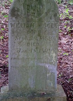
William Harrison (Kuhl) Cole
| Birth | : | 26 Sep 1833 Germany |
| Death | : | 18 Jul 1891 Glenville, Gilmer County, West Virginia, USA |
| Burial | : | Blackburn Cemetery, Blackburn, Gilmer County, USA |
| Coordinate | : | 38.9235700, -80.6743200 |
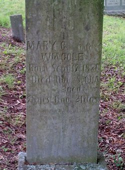
| Description | : | Married: Mary Elizabeth Hefner on January 8, 1860 in Glenville, Gilmer Co, West Virginia Born with and the surname on marriage certificate was William Harrison KUHL. First couple of children were born with the spelling KUHL not Cole. William Harrison (Kuhl) Cole and one brother, Henry J. (Kuhl) Cole changed the spelling of their surnames from KUHL to COLE. They changed the spelling during the civil war or just after due to an incident during the civil war that happened to their father, Henry Kuhl. The remaining 4 siblings and 4 half-siblings kept their surname spelling as KUHL. |
frequently asked questions (FAQ):
-
Where is William Harrison (Kuhl) Cole's memorial?
William Harrison (Kuhl) Cole's memorial is located at: Blackburn Cemetery, Blackburn, Gilmer County, USA.
-
When did William Harrison (Kuhl) Cole death?
William Harrison (Kuhl) Cole death on 18 Jul 1891 in Glenville, Gilmer County, West Virginia, USA
-
Where are the coordinates of the William Harrison (Kuhl) Cole's memorial?
Latitude: 38.9235700
Longitude: -80.6743200
Family Members:
Parent
Spouse
Siblings

Children
Flowers:


Nearby Cemetories:
1. Blackburn Cemetery
Blackburn, Gilmer County, USA
Coordinate: 38.9235700, -80.6743200
2. Tumbling Cemetery
Gilmer County, USA
Coordinate: 38.9085999, -80.6594009
3. Tomblin Cemetery
Blackburn, Gilmer County, USA
Coordinate: 38.9076650, -80.6597330
4. Canfield Cemetery
Gilmer, Gilmer County, USA
Coordinate: 38.9071999, -80.6900024
5. Rogers Cemetery
Gilmer County, USA
Coordinate: 38.9406013, -80.6936035
6. Schoonover-Dawson Cemetery
Donlan, Gilmer County, USA
Coordinate: 38.9461770, -80.6854790
7. Locust Knob Cemetery
Stouts Mills, Gilmer County, USA
Coordinate: 38.8990000, -80.6880000
8. Boilon Cemetery
Gilmer County, USA
Coordinate: 38.9519005, -80.6718979
9. Snyder Cemetery
Gilmer County, USA
Coordinate: 38.9006004, -80.6964035
10. Dyer Cemetery
Gilmer County, USA
Coordinate: 38.9319000, -80.7110977
11. McHenry Cemetery
Gilmer County, USA
Coordinate: 38.9341870, -80.7130200
12. Mick Cemetery
Gilmer County, USA
Coordinate: 38.9157200, -80.6316400
13. McHenry Cemetery #1
Sand Fork, Gilmer County, USA
Coordinate: 38.9353310, -80.7162630
14. Varner Cemetery
Sand Fork, Gilmer County, USA
Coordinate: 38.9254709, -80.7212012
15. Keith Cemetery
Gilmer County, USA
Coordinate: 38.9561005, -80.6986008
16. Killingsworth Cemetery
Sand Fork, Gilmer County, USA
Coordinate: 38.9169640, -80.7249834
17. Pumphrey Cemetery
Orlando, Lewis County, USA
Coordinate: 38.9275880, -80.6216500
18. Conrad Cemetery
Sand Fork, Gilmer County, USA
Coordinate: 38.9364014, -80.7296982
19. Unity Memorial Garden
Eastover, Richland County, USA
Coordinate: 38.8840220, -80.7040760
20. Barrett Cemetery
Burnsville, Braxton County, USA
Coordinate: 38.8778000, -80.6528015
21. Longshoal Cemetery
Gilmer, Gilmer County, USA
Coordinate: 38.8774030, -80.7055340
22. Dusk Camp United Methodist Church Cemetery
Gilmer County, USA
Coordinate: 38.8961140, -80.7325440
23. Heater Cemetery
Burnsville, Braxton County, USA
Coordinate: 38.9024560, -80.6100370
24. Queen Family Cemetery
Copley, Lewis County, USA
Coordinate: 38.9499000, -80.6130000