
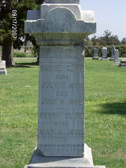
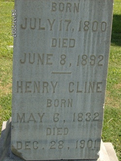
William Henry Cline
| Birth | : | 6 May 1832 Allegany County, New York, USA |
| Death | : | 28 Dec 1901 San Bernardino, San Bernardino County, California, USA |
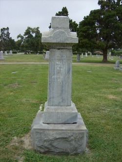
| Burial | : | Dysart Cemetery, Dysart, Tama County, USA |
| Coordinate | : | 42.1608009, -92.3193970 |
| Plot | : | block 8 |
| Description | : | Son of Daniel Cline. Listed by the San Bernardino Historical Society as a member in 1892. He went by the name of Henry. The San Francisco Examiner states he shunned his fellow man and hated children, which was very unusual for a member of the Society. Henry "hanged more murderers than any other man in the country" San Bernardino sheriffs hired Mr.Cline for his services. 1880 Census Chino,CA listed age 48 as a stock raiser widower. 1900 Census Chino, CA he is by himself. His father would have died and he is listed as a widower. |
frequently asked questions (FAQ):
-
Where is William Henry Cline's memorial?
William Henry Cline's memorial is located at: Dysart Cemetery, Dysart, Tama County, USA.
-
When did William Henry Cline death?
William Henry Cline death on 28 Dec 1901 in San Bernardino, San Bernardino County, California, USA
-
Where are the coordinates of the William Henry Cline's memorial?
Latitude: 42.1608009
Longitude: -92.3193970
Family Members:
Parent

Siblings
Children
Flowers:


Nearby Cemetories:
1. Saint Josephs Catholic Cemetery
Benton County, USA
Coordinate: 42.1719017, -92.2981033
2. Rampton Cemetery
Monroe Township, Benton County, USA
Coordinate: 42.1866989, -92.2605972
3. Houghton Cemetery
Benton County, USA
Coordinate: 42.1088982, -92.2794037
4. Gnagy Cemetery
Benton County, USA
Coordinate: 42.1418991, -92.2416992
5. Brown Bruce Township Cemetery
Benton County, USA
Coordinate: 42.2163430, -92.2799680
6. Urmy Cemetery
Benton County, USA
Coordinate: 42.1719017, -92.2281036
7. Lone Pine Cemetery
Tama County, USA
Coordinate: 42.0797005, -92.3082962
8. Oneida Cemetery
Clutier, Tama County, USA
Coordinate: 42.1007996, -92.3966980
9. Hill Cemetery
Tama County, USA
Coordinate: 42.2542000, -92.3075027
10. Clutier Cemetery
Clutier, Tama County, USA
Coordinate: 42.0792007, -92.3858032
11. West Union Cemetery
Traer, Tama County, USA
Coordinate: 42.1817017, -92.4449997
12. Spencer Cemetery
Dysart, Tama County, USA
Coordinate: 42.2592120, -92.3353840
13. Fairview Cemetery
Benton County, USA
Coordinate: 42.2141991, -92.2007980
14. Roadside Cemetery
Clutier, Tama County, USA
Coordinate: 42.0574800, -92.3548800
15. Saint Pauls Catholic Cemetery
Traer, Tama County, USA
Coordinate: 42.1832000, -92.4688000
16. Twogood Cemetery
Benton County, USA
Coordinate: 42.0499992, -92.2799988
17. Geneseo Cemetery
Buckingham, Tama County, USA
Coordinate: 42.2764370, -92.3523950
18. Saint Wenceslaus Cemetery
Clutier, Tama County, USA
Coordinate: 42.0870000, -92.4460000
19. Kirchner Cemetery
Benton County, USA
Coordinate: 42.0727300, -92.2027400
20. Buckingham Cemetery
Traer, Tama County, USA
Coordinate: 42.2069016, -92.4741974
21. Waltham Cemetery
Elberon, Tama County, USA
Coordinate: 42.0355988, -92.3328018
22. Big Grove-Homer Cemetery
Benton County, USA
Coordinate: 42.0867004, -92.1821976
23. Garrison Cemetery
Garrison, Benton County, USA
Coordinate: 42.1369019, -92.1483002
24. Carlisle Grove Cemetery
Garrison, Benton County, USA
Coordinate: 42.1730995, -92.1386032