
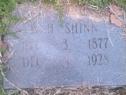
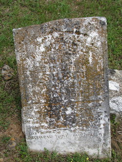
William Henry Shinn
| Birth | : | 3 Dec 1877 |
| Death | : | 8 Dec 1928 |
| Burial | : | Mount Hope Cemetery, Omaha, Douglas County, USA |
| Coordinate | : | 41.3041992, -96.0310974 |
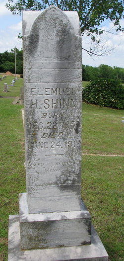
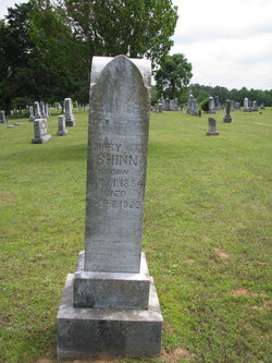
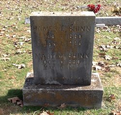
| Description | : | Father: Elemuel H. "Lemuel" Shinn Mother: Mary Jane McGee Married Olive Perthena "Ollie" Firman December 24, 1890 in Pope County, Arkansas Children: Lucy Ethel Shinn Henryette Shinn William Boyd Shinn Lemuel Ray Shinn Mary Shinn Earl Shinn Ollie, Earl and William Boyd are buried in the North New Hope Cemetery, Dover, Pope County, Arkansas |
frequently asked questions (FAQ):
-
Where is William Henry Shinn's memorial?
William Henry Shinn's memorial is located at: Mount Hope Cemetery, Omaha, Douglas County, USA.
-
When did William Henry Shinn death?
William Henry Shinn death on 8 Dec 1928 in
-
Where are the coordinates of the William Henry Shinn's memorial?
Latitude: 41.3041992
Longitude: -96.0310974
Family Members:
Parent
Spouse
Siblings
Children
Flowers:


Nearby Cemetories:
1. Mount Hope Cemetery
Omaha, Douglas County, USA
Coordinate: 41.3041992, -96.0310974
2. Servants of Mary Cemetery
Omaha, Douglas County, USA
Coordinate: 41.3017170, -96.0258260
3. Mount Sinai Cemetery
Omaha, Douglas County, USA
Coordinate: 41.3116989, -96.0314026
4. Springwell Cemetery
Omaha, Douglas County, USA
Coordinate: 41.3114014, -96.0096970
5. All Saints Episcopal Church Columbarium
Omaha, Douglas County, USA
Coordinate: 41.2785000, -96.0579000
6. Potter Field
Omaha, Douglas County, USA
Coordinate: 41.3320274, -95.9902878
7. Forest Lawn Memorial Park
Omaha, Douglas County, USA
Coordinate: 41.3272018, -95.9847031
8. Golden Hill Cemetery
Omaha, Douglas County, USA
Coordinate: 41.3050003, -95.9744034
9. Pleasant Hill Jewish Cemetery
Omaha, Douglas County, USA
Coordinate: 41.3185997, -95.9766998
10. Union Memorial Cemetery
Omaha, Douglas County, USA
Coordinate: 41.3512611, -96.0620193
11. Saint Andrews Episcopal Church Columbarium
Omaha, Douglas County, USA
Coordinate: 41.2492500, -96.0427500
12. Mormon Pioneer Cemetery
Omaha, Douglas County, USA
Coordinate: 41.3348450, -95.9663720
13. Countryside Community Church Columbarium
Omaha, Douglas County, USA
Coordinate: 41.2483660, -96.0500270
14. Nash Chapel Crypt
Omaha, Douglas County, USA
Coordinate: 41.2665090, -95.9721790
15. Holy Sepulchre Cemetery
Omaha, Douglas County, USA
Coordinate: 41.2543983, -95.9875031
16. Prospect Hill Cemetery
Omaha, Douglas County, USA
Coordinate: 41.2780991, -95.9593964
17. Ak-Sar-Ben Racetrack Grounds
Omaha, Douglas County, USA
Coordinate: 41.2414703, -96.0159607
18. Evergreen Memorial Park Cemetery
Omaha, Douglas County, USA
Coordinate: 41.2393990, -96.0355988
19. Calvary Cemetery
Omaha, Douglas County, USA
Coordinate: 41.2364006, -96.0294037
20. First Central Congregational Columbarium
Omaha, Douglas County, USA
Coordinate: 41.2563456, -95.9658365
21. Resurrection Cemetery
Omaha, Douglas County, USA
Coordinate: 41.2344208, -96.0365448
22. Bohemian Cemetery
Omaha, Douglas County, USA
Coordinate: 41.2388992, -95.9955978
23. Westlawn-Hillcrest Memorial Park
Omaha, Douglas County, USA
Coordinate: 41.2346992, -95.9966965
24. Douglas County Poor Farm Cemetery
Omaha, Douglas County, USA
Coordinate: 41.2437240, -95.9723480