

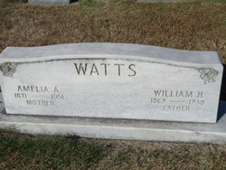
William Henry Watts
| Birth | : | 19 Sep 1869 Mahanoy City, Schuylkill County, Pennsylvania, USA |
| Death | : | 5 Jul 1938 Sherman County, Nebraska, USA |
| Burial | : | Evergreen Cemetery, Loup City, Sherman County, USA |
| Coordinate | : | 41.2997017, -98.9852982 |
| Description | : | Lightning Kills W. H. Watts Tuesday Evening Was Running Binder When Struck; Funeral Services Friday. W. H. Watts, prominent Sherman county farmer, was instantly killed about seven o'clock Tuesday evening when struck by lightning as he was cutting grain with a binder. He was driving a four horse team, and though they were knocked down, they were not seriously hurt. Mr. Watts was 68 years of age. Funeral services will be held Friday afternoon at the Methodist church at two o'clock. Burial will be made in Evergreen cemetery. Mr. Watts is survived by his widow, four daughters and a son. Complete obituary will be... Read More |
frequently asked questions (FAQ):
-
Where is William Henry Watts's memorial?
William Henry Watts's memorial is located at: Evergreen Cemetery, Loup City, Sherman County, USA.
-
When did William Henry Watts death?
William Henry Watts death on 5 Jul 1938 in Sherman County, Nebraska, USA
-
Where are the coordinates of the William Henry Watts's memorial?
Latitude: 41.2997017
Longitude: -98.9852982
Family Members:
Parent
Spouse
Siblings
Children

Flowers:


Nearby Cemetories:
1. Evergreen Cemetery
Loup City, Sherman County, USA
Coordinate: 41.2997017, -98.9852982
2. Saint Josaphats Cemetery
Loup City, Sherman County, USA
Coordinate: 41.3022003, -98.9847031
3. Sunny Slope Cemetery
Loup City, Sherman County, USA
Coordinate: 41.2906000, -99.0267000
4. Cleoria Cemetery
Loup City, Sherman County, USA
Coordinate: 41.2779000, -99.0893500
5. Balsora Cemetery
Sherman County, USA
Coordinate: 41.3782997, -99.0975037
6. Austin Cemetery
Rockville, Sherman County, USA
Coordinate: 41.1880989, -98.8981018
7. Verdurette Cemetery
Sherman County, USA
Coordinate: 41.1697006, -98.9757996
8. Davis Creek Cemetery
Valley County, USA
Coordinate: 41.4219017, -98.9052963
9. Saint Francis Cemetery
Ashton, Sherman County, USA
Coordinate: 41.2438000, -98.7994000
10. Lone Elm Cemetery
Loup City, Sherman County, USA
Coordinate: 41.2921982, -99.1864014
11. Immanuel Lutheran Cemetery
Ashton, Sherman County, USA
Coordinate: 41.2140000, -98.8142000
12. Gray Cemetery
Sherman County, USA
Coordinate: 41.2099991, -99.1567001
13. Arcadia Cemetery
Arcadia, Valley County, USA
Coordinate: 41.4237000, -99.1167000
14. Pleasant Hill Friends Cemetery
Valley County, USA
Coordinate: 41.4230800, -98.8377700
15. Dunkard Cemetery
Arcadia, Valley County, USA
Coordinate: 41.4522000, -99.0769000
16. Union Cemetery
Ashton, Sherman County, USA
Coordinate: 41.2214012, -98.7855988
17. Litchfield Cemetery
Litchfield, Sherman County, USA
Coordinate: 41.1543999, -99.1283035
18. Mount Carmel Cemetery
Howard County, USA
Coordinate: 41.2797012, -98.7328033
19. Salem Evangelical Church Cemetery
Ord, Valley County, USA
Coordinate: 41.4902992, -98.9244003
20. Lewis Burial Plat
Litchfield, Sherman County, USA
Coordinate: 41.1383000, -99.1484000
21. Trinity Lutheran Church Cemetery
Hazard, Sherman County, USA
Coordinate: 41.0913000, -99.0052000
22. Lee Park Cemetery
Custer County, USA
Coordinate: 41.4025002, -99.2307968
23. Lee Park Catholic Cemetery
Westerville, Custer County, USA
Coordinate: 41.4091988, -99.2311020
24. Saint Marys Cemetery
Rockville, Sherman County, USA
Coordinate: 41.1202000, -98.8255000