
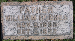
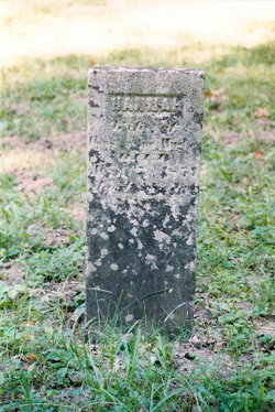
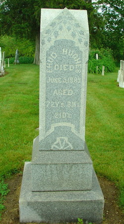
William Hughes
| Birth | : | 9 Nov 1830 |
| Death | : | 3 Oct 1922 |
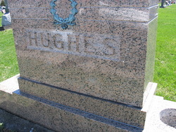
| Burial | : | Visitation Catholic Cemetery, Stacyville, Mitchell County, USA |
| Coordinate | : | 43.4430618, -92.7813873 |
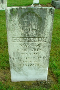
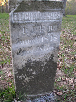
| Description | : | Shares plot with central Hughes marker. Other graves in plot are Hesterann Hughes and Oral T. Hughes. William was married first on September 24, 1848, to Cynthe Ann Smith. He married second to Hesterann Spry on March 24, 1858. |
frequently asked questions (FAQ):
-
Where is William Hughes's memorial?
William Hughes's memorial is located at: Visitation Catholic Cemetery, Stacyville, Mitchell County, USA.
-
When did William Hughes death?
William Hughes death on 3 Oct 1922 in
-
Where are the coordinates of the William Hughes's memorial?
Latitude: 43.4430618
Longitude: -92.7813873
Family Members:
Parent
Spouse
Siblings
Children

Flowers:


Nearby Cemetories:
1. Stacyville Cemetery
Stacyville, Mitchell County, USA
Coordinate: 43.4294014, -92.7908020
2. Union Presbyterian Cemetery
Stacyville, Mitchell County, USA
Coordinate: 43.4797211, -92.8088913
3. Union Township Cemetery
Toeterville, Mitchell County, USA
Coordinate: 43.4578018, -92.8491974
4. Sacred Heart Cemetery
Meyer, Mitchell County, USA
Coordinate: 43.4583282, -92.7011108
5. Saint Johns Cemetery
Johnsburg, Mower County, USA
Coordinate: 43.5055618, -92.7688904
6. Liberty Cemetery
Little Cedar, Mitchell County, USA
Coordinate: 43.3856010, -92.7230988
7. Saint Peter Cemetery
Toeterville, Mitchell County, USA
Coordinate: 43.4402809, -92.8897171
8. Robbins Cemetery
David (historical), Mitchell County, USA
Coordinate: 43.4150009, -92.6718979
9. Six Mile Grove Cemetery
Lyle, Mower County, USA
Coordinate: 43.5069389, -92.8836136
10. Saint Patricks Church Cemetery
McIntire, Mitchell County, USA
Coordinate: 43.4771996, -92.6508026
11. Saint Ansgar Cemetery
Saint Ansgar, Mitchell County, USA
Coordinate: 43.3777809, -92.9094391
12. Rustad Cemetery
Otranto, Mitchell County, USA
Coordinate: 43.4585991, -92.9400024
13. First Lutheran Cemetery
Saint Ansgar, Mitchell County, USA
Coordinate: 43.3841705, -92.9194412
14. Mona Cemetery
Mona, Mitchell County, USA
Coordinate: 43.4824982, -92.9402771
15. McKinley Cemetery
Saint Ansgar, Mitchell County, USA
Coordinate: 43.3906400, -92.9368300
16. Pleasant Hill Cemetery
Mona, Mitchell County, USA
Coordinate: 43.4768982, -92.9467010
17. Immanuel Lutheran Cemetery
Saint Ansgar, Mitchell County, USA
Coordinate: 43.3717003, -92.9257965
18. Sacred Heart Cemetery
Adams, Mower County, USA
Coordinate: 43.5635986, -92.7221985
19. Beaver Creek Cemetery
Brownville, Mitchell County, USA
Coordinate: 43.3397217, -92.6727829
20. Little Cedar Cemetery
Adams, Mower County, USA
Coordinate: 43.5736008, -92.7574997
21. Ogden Cemetery
Otranto, Mitchell County, USA
Coordinate: 43.4366989, -92.9681015
22. Blakestad Cemetery
Saint Ansgar, Mitchell County, USA
Coordinate: 43.3711014, -92.9400024
23. Riverview Cemetery
Saint Ansgar, Mitchell County, USA
Coordinate: 43.3430328, -92.9220200
24. Oak Grove Cemetery
Mitchell, Mitchell County, USA
Coordinate: 43.3156013, -92.8707962