
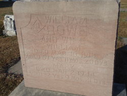
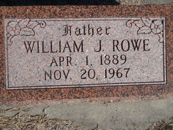
William John “Billy” Rowe
| Birth | : | 9 Apr 1850 Constantine, Cornwall Unitary Authority, Cornwall, England |
| Death | : | 16 Mar 1918 Loup City, Sherman County, Nebraska, USA |
| Burial | : | Evergreen Cemetery, Loup City, Sherman County, USA |
| Coordinate | : | 41.2997017, -98.9852982 |
| Description | : | Son of Charles and Ann/Nancy Rowe (both b. and d. ENG) ---------------------------------------------- William Rowe Dead The community was greatly shocked last Sunday when the announcement was made that "Billy" Rowe was numbered among the dead, and that he departed on the evening of March 16 at about 8 o'clock. Mr. Rowe was sick only about ten days, and when first taken sick he was considered quite serious, but recovered and was able to go down town, and there was every indication that he would be ready to go to work again in a few days, but he suffered a relapse and in three days... Read More |
frequently asked questions (FAQ):
-
Where is William John “Billy” Rowe's memorial?
William John “Billy” Rowe's memorial is located at: Evergreen Cemetery, Loup City, Sherman County, USA.
-
When did William John “Billy” Rowe death?
William John “Billy” Rowe death on 16 Mar 1918 in Loup City, Sherman County, Nebraska, USA
-
Where are the coordinates of the William John “Billy” Rowe's memorial?
Latitude: 41.2997017
Longitude: -98.9852982
Family Members:
Spouse

Children
Flowers:


Nearby Cemetories:
1. Evergreen Cemetery
Loup City, Sherman County, USA
Coordinate: 41.2997017, -98.9852982
2. Saint Josaphats Cemetery
Loup City, Sherman County, USA
Coordinate: 41.3022003, -98.9847031
3. Sunny Slope Cemetery
Loup City, Sherman County, USA
Coordinate: 41.2906000, -99.0267000
4. Cleoria Cemetery
Loup City, Sherman County, USA
Coordinate: 41.2779000, -99.0893500
5. Balsora Cemetery
Sherman County, USA
Coordinate: 41.3782997, -99.0975037
6. Austin Cemetery
Rockville, Sherman County, USA
Coordinate: 41.1880989, -98.8981018
7. Verdurette Cemetery
Sherman County, USA
Coordinate: 41.1697006, -98.9757996
8. Davis Creek Cemetery
Valley County, USA
Coordinate: 41.4219017, -98.9052963
9. Saint Francis Cemetery
Ashton, Sherman County, USA
Coordinate: 41.2438000, -98.7994000
10. Lone Elm Cemetery
Loup City, Sherman County, USA
Coordinate: 41.2921982, -99.1864014
11. Immanuel Lutheran Cemetery
Ashton, Sherman County, USA
Coordinate: 41.2140000, -98.8142000
12. Gray Cemetery
Sherman County, USA
Coordinate: 41.2099991, -99.1567001
13. Arcadia Cemetery
Arcadia, Valley County, USA
Coordinate: 41.4237000, -99.1167000
14. Pleasant Hill Friends Cemetery
Valley County, USA
Coordinate: 41.4230800, -98.8377700
15. Dunkard Cemetery
Arcadia, Valley County, USA
Coordinate: 41.4522000, -99.0769000
16. Union Cemetery
Ashton, Sherman County, USA
Coordinate: 41.2214012, -98.7855988
17. Litchfield Cemetery
Litchfield, Sherman County, USA
Coordinate: 41.1543999, -99.1283035
18. Mount Carmel Cemetery
Howard County, USA
Coordinate: 41.2797012, -98.7328033
19. Salem Evangelical Church Cemetery
Ord, Valley County, USA
Coordinate: 41.4902992, -98.9244003
20. Lewis Burial Plat
Litchfield, Sherman County, USA
Coordinate: 41.1383000, -99.1484000
21. Trinity Lutheran Church Cemetery
Hazard, Sherman County, USA
Coordinate: 41.0913000, -99.0052000
22. Lee Park Cemetery
Custer County, USA
Coordinate: 41.4025002, -99.2307968
23. Lee Park Catholic Cemetery
Westerville, Custer County, USA
Coordinate: 41.4091988, -99.2311020
24. Saint Marys Cemetery
Rockville, Sherman County, USA
Coordinate: 41.1202000, -98.8255000