
| Birth | : | 19 Mar 1902 Saint Joseph, Cloud County, Kansas, USA |
| Death | : | 11 Mar 1977 Concordia, Cloud County, Kansas, USA |
| Burial | : | Mount Calvary Cemetery, Clyde, Cloud County, USA |
| Coordinate | : | 39.5917015, -97.4143982 |
| Plot | : | Site A/17 |
| Inscription | : | Parents of Rita |
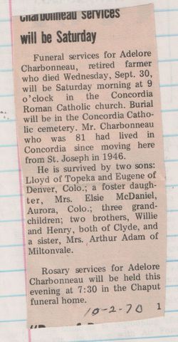
| Description | : | Salina Journal – Mar. 13, 1977 CLYDE — The funeral for Willie J. Charbonneau, 74, Clyde, will be at 10 am Monday at St. John the Baptist Roman Catholic Church, Clyde, the Rev. Robert Vering officiating. Burial will be in Mt. Calvary cemetery, Clyde. Mr. Charbonneau died Friday at St. Joseph Hospital, Concordia. He was born March 19, 1902, at St. Joe, Kan. He moved to Clyde in 1962 after retiring from the Service Pipeline Co. He was a member of St. John the Baptist Catholic Church and the Clyde Knights of Columbus. Survivors are the widow, Jennette; a daughter, Mrs. Rita Callaway,... Read More |
frequently asked questions (FAQ):
-
Where is William Joseph “Willie” Charbonneau's memorial?
William Joseph “Willie” Charbonneau's memorial is located at: Mount Calvary Cemetery, Clyde, Cloud County, USA.
-
When did William Joseph “Willie” Charbonneau death?
William Joseph “Willie” Charbonneau death on 11 Mar 1977 in Concordia, Cloud County, Kansas, USA
-
Where are the coordinates of the William Joseph “Willie” Charbonneau's memorial?
Latitude: 39.5917015
Longitude: -97.4143982
Family Members:
Parent

Spouse

Siblings
Children
Flowers:


Nearby Cemetories:
1. Mount Calvary Cemetery
Clyde, Cloud County, USA
Coordinate: 39.5917015, -97.4143982
2. Mount Hope Cemetery
Clyde, Cloud County, USA
Coordinate: 39.5969009, -97.4116974
3. Cedar Grove Cemetery
Clyde, Cloud County, USA
Coordinate: 39.5494003, -97.4056015
4. Pleasant View Cemetery
Ames, Cloud County, USA
Coordinate: 39.5346985, -97.4431000
5. Walnut Grove Cemetery
Cloud County, USA
Coordinate: 39.5699997, -97.4993973
6. Saint Joseph Cemetery
Saint Joseph, Cloud County, USA
Coordinate: 39.5074941, -97.4022328
7. Agenda Cemetery
Agenda, Republic County, USA
Coordinate: 39.6761017, -97.4336014
8. Green Mound Cemetery
Rice, Cloud County, USA
Coordinate: 39.5248450, -97.5081630
9. Hollis Cemetery
Cloud County, USA
Coordinate: 39.6383018, -97.5361023
10. Beck Family Cemetery
Agenda, Republic County, USA
Coordinate: 39.6818000, -97.4863000
11. Rice Cemetery
Rice, Cloud County, USA
Coordinate: 39.5614014, -97.5552979
12. Nelson Cemetery
Rice, Cloud County, USA
Coordinate: 39.5257988, -97.5410995
13. Riverdale Cemetery
Clay County, USA
Coordinate: 39.5106010, -97.2930984
14. Saint Peters Cemetery
Aurora, Cloud County, USA
Coordinate: 39.4763985, -97.5180969
15. Princeville Cemetery
Aurora, Cloud County, USA
Coordinate: 39.4672012, -97.5010986
16. Iwacura Cemetery
Morganville, Clay County, USA
Coordinate: 39.4550000, -97.3510000
17. Union Cemetery
Wayne, Republic County, USA
Coordinate: 39.6977997, -97.5457993
18. Willoughby Cemetery
Agenda, Republic County, USA
Coordinate: 39.7402992, -97.4244003
19. French Presbyterian Church Cemetery
Cloud County, USA
Coordinate: 39.4395200, -97.4148290
20. Gotland Cemetery
Sibley Township, Cloud County, USA
Coordinate: 39.6091995, -97.6125031
21. Sherman Cemetery
Morganville, Clay County, USA
Coordinate: 39.5316300, -97.2243700
22. Zion Cemetery
Agenda, Republic County, USA
Coordinate: 39.6749992, -97.5939026
23. Rose Hill Cemetery
Wayne, Republic County, USA
Coordinate: 39.7111015, -97.5661011
24. Minersville Cemetery
Talmo, Republic County, USA
Coordinate: 39.6568330, -97.6229250