

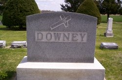
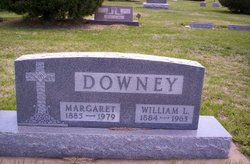
William Lawrence Downey
| Birth | : | 8 Aug 1884 Glasco, Cloud County, Kansas, USA |
| Death | : | 8 Jun 1963 Concordia, Cloud County, Kansas, USA |
| Burial | : | Holy Sepulchre Cemetery, Southfield, Oakland County, USA |
| Coordinate | : | 42.4813995, -83.3028030 |
| Plot | : | 4CW11 |
| Description | : | Glasco Sun, June 13, 1963, page 1: William L. Downey Funeral Was Tuesday Funeral services were held Tuesday morning for William Lawrence Downey, 78, life-long resident of Glasco, from St. Mary's Catholic Church, with father Robert Vering officiating. He passed away Saturday, June 8, at St. Joseph's Hospital in Concordia. Mr. Downey was born in a log cabin August 8, 1884, at the present site of the NGPL booster station, to John and Hanora Downey. He was the last surviving member of a family of 15. He was married to Margaret Frances Callahan April 26, 1911, at St. Peter's Church in Meredith... Read More |
frequently asked questions (FAQ):
-
Where is William Lawrence Downey's memorial?
William Lawrence Downey's memorial is located at: Holy Sepulchre Cemetery, Southfield, Oakland County, USA.
-
When did William Lawrence Downey death?
William Lawrence Downey death on 8 Jun 1963 in Concordia, Cloud County, Kansas, USA
-
Where are the coordinates of the William Lawrence Downey's memorial?
Latitude: 42.4813995
Longitude: -83.3028030
Family Members:
Parent

Spouse
Siblings

Children
Flowers:


Nearby Cemetories:
1. Holy Sepulchre Cemetery
Southfield, Oakland County, USA
Coordinate: 42.4813995, -83.3028030
2. Congregation for Humanistic Judaism Peace Garden
Farmington Hills, Oakland County, USA
Coordinate: 42.4989110, -83.3299670
3. East Farmington Cemetery
Farmington Hills, Oakland County, USA
Coordinate: 42.5003014, -83.3296967
4. Nardin Park United Methodist Church Memorial Garde
Farmington Hills, Oakland County, USA
Coordinate: 42.4848680, -83.3414050
5. Southfield Cemetery
Southfield, Oakland County, USA
Coordinate: 42.4749985, -83.2608032
6. Pioneer Cemetery
Southfield, Oakland County, USA
Coordinate: 42.4749140, -83.2603170
7. Franklin Cemetery
Franklin, Oakland County, USA
Coordinate: 42.5224991, -83.3059921
8. Franklin Community Church Columbarium
Franklin, Oakland County, USA
Coordinate: 42.5258470, -83.3100450
9. Clarenceville Cemetery
Livonia, Wayne County, USA
Coordinate: 42.4411011, -83.3324966
10. Southfield Reformed Cemetery
Southfield, Oakland County, USA
Coordinate: 42.4848420, -83.2405580
11. Dun Scotus - Franciscan Catholic Cemetery
Southfield, Oakland County, USA
Coordinate: 42.4609690, -83.2437940
12. Northbrook Presbyterian Church Columbarium
Beverly Hills, Oakland County, USA
Coordinate: 42.5297550, -83.2657280
13. First Presbyterian Church Cope Memorial Garden
Farmington Hills, Oakland County, USA
Coordinate: 42.4847290, -83.3785190
14. Greater Grace Temple of the Apostolic Faith Garden
Detroit, Wayne County, USA
Coordinate: 42.4297295, -83.2711334
15. Oakwood Cemetery
Farmington, Oakland County, USA
Coordinate: 42.4700012, -83.3850021
16. Quaker Cemetery
Farmington, Oakland County, USA
Coordinate: 42.4642181, -83.3860626
17. Mount Hazel Cemetery
Detroit, Wayne County, USA
Coordinate: 42.4253006, -83.2566986
18. Grand Lawn Cemetery
Detroit, Wayne County, USA
Coordinate: 42.4188995, -83.2724991
19. North Farmington Cemetery
Farmington Hills, Oakland County, USA
Coordinate: 42.5181007, -83.3783035
20. Mount Hope Memorial Gardens
Livonia, Wayne County, USA
Coordinate: 42.4160995, -83.3324966
21. Beekman Cemetery
Southfield, Oakland County, USA
Coordinate: 42.5098076, -83.2176285
22. Beth El Memorial Park Cemetery
Livonia, Wayne County, USA
Coordinate: 42.4146996, -83.3274994
23. Adat Shalom Memorial Park
Livonia, Wayne County, USA
Coordinate: 42.4146996, -83.3300018
24. Saint David Episcopal Church Columbarium
Southfield, Oakland County, USA
Coordinate: 42.5030990, -83.2096400