
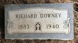
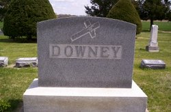
Richard Downey
| Birth | : | 8 Oct 1883 Glasco, Cloud County, Kansas, USA |
| Death | : | 11 Nov 1940 Concordia, Cloud County, Kansas, USA |
| Burial | : | Mount Carmel Cemetery, Clifton Hill, Randolph County, USA |
| Coordinate | : | 39.5825400, -92.6701700 |
| Description | : | Link to spouse sent by Rainbow, 47002487 ********************* Glasco Sun, Nov. 14, 1940, page 1: The grim reaper, Death, has taken a heavy toll from Glasco the past week and saddened this community and brought sorrow to many hearts by the loss of loved ones. ......then Richard Downey who came to death in the bitter coldness of the sudden storm Sunday evening...... Delphos Republican, Nov. 14, 1940, page 1: IS STORM VICTIM Rich Downey of Glasco Frozen to Death in Snow A victim of the weekend storm of ice and snow which raged here, the body of Richard Downey... Read More |
frequently asked questions (FAQ):
-
Where is Richard Downey's memorial?
Richard Downey's memorial is located at: Mount Carmel Cemetery, Clifton Hill, Randolph County, USA.
-
When did Richard Downey death?
Richard Downey death on 11 Nov 1940 in Concordia, Cloud County, Kansas, USA
-
Where are the coordinates of the Richard Downey's memorial?
Latitude: 39.5825400
Longitude: -92.6701700
Family Members:
Parent

Spouse
Siblings

Flowers:


Nearby Cemetories:
1. Mount Carmel Cemetery
Clifton Hill, Randolph County, USA
Coordinate: 39.5825400, -92.6701700
2. Clardy Cemetery
Randolph County, USA
Coordinate: 39.5901710, -92.6709040
3. Dameron Family Cemetery
Randolph County, USA
Coordinate: 39.5952870, -92.6459750
4. Hebron Cemetery
Macon, Macon County, USA
Coordinate: 39.6171608, -92.6407776
5. Eldad Cumberland Presbyterian Cemetery
Randolph County, USA
Coordinate: 39.5380800, -92.6190800
6. Mount Olivette Cemetery
Darksville, Randolph County, USA
Coordinate: 39.5949170, -92.5946970
7. Broaddus Cemetery
Darksville, Randolph County, USA
Coordinate: 39.5655550, -92.5902770
8. Kitchen Cemetery
Macon County, USA
Coordinate: 39.6164100, -92.5964000
9. Fawks Cemetery
Wayland Township, Chariton County, USA
Coordinate: 39.5264015, -92.7288971
10. Darksville Cemetery
Darksville, Randolph County, USA
Coordinate: 39.5542700, -92.5814900
11. Mount Shiloh Baptist Church Cemetery
Darksville, Randolph County, USA
Coordinate: 39.5534360, -92.5814940
12. Hall Family Cemetery
Darksville, Randolph County, USA
Coordinate: 39.5613890, -92.5769090
13. Marvin-Carter Cemetery
Randolph County, USA
Coordinate: 39.5957680, -92.5744400
14. McCully-Haines Cemetery
Randolph County, USA
Coordinate: 39.5080870, -92.6410220
15. Hickory Grove Cemetery
Randolph County, USA
Coordinate: 39.5402985, -92.5852966
16. Prairie Hill Cemetery
Wayland Township, Chariton County, USA
Coordinate: 39.5121994, -92.7153015
17. Barnhart Cemetery
Randolph County, USA
Coordinate: 39.5731010, -92.5671997
18. College Mound Cemetery
College Mound, Macon County, USA
Coordinate: 39.6227600, -92.5749400
19. Johnson Cemetery
Bee Branch Township, Chariton County, USA
Coordinate: 39.6500015, -92.7369003
20. Morrow Family Cemetery
Callao, Macon County, USA
Coordinate: 39.6693400, -92.6453410
21. Martin Green Cemetery
Randolph County, USA
Coordinate: 39.4972340, -92.6369320
22. Krueger Cemetery
Cockrell Township, Chariton County, USA
Coordinate: 39.5891991, -92.7879028
23. Rice Cemetery
Bee Branch Township, Chariton County, USA
Coordinate: 39.6652985, -92.7341995
24. Cleveland Cemetery
Darksville, Randolph County, USA
Coordinate: 39.5018380, -92.6006240