
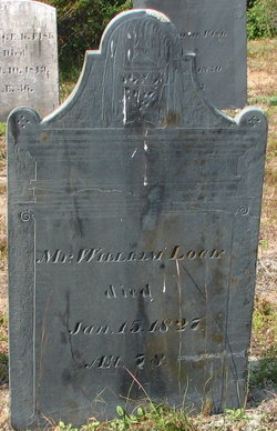
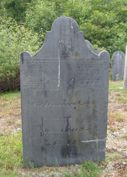
William Locke
| Birth | : | 23 Aug 1748 Lancaster, Worcester County, Massachusetts, USA |
| Death | : | 15 Jan 1827 New Ipswich, Hillsborough County, New Hampshire, USA |
| Burial | : | Cadet Creek Cemetery, Loose Creek, Osage County, USA |
| Coordinate | : | 38.5367012, -91.9828033 |
| Plot | : | C330 |
| Description | : | He succeeded to his father's inn at Lancaster, in which town he lived until about 1798, when he removed to Rindge, and then in a few years to New Ipswich. He bought the Barr farm, (64, N. L. O.,) but soon after his second marriage he removed to the farm of his wife, (IV : 2,S. R.) Parents: Samuel Locke & Rebecca Richardson Married: #1 Mary Fowler, June 18,1772 Children: Mary, William, Anna, Polly, Josiah, James, Nancy, Lucretia. #2 Hannah Woolson, April 13,1813 Source: The History of New Ipswich, N.H. 1735-1914, Charles Henry Chandler, page 515,516. |
frequently asked questions (FAQ):
-
Where is William Locke's memorial?
William Locke's memorial is located at: Cadet Creek Cemetery, Loose Creek, Osage County, USA.
-
When did William Locke death?
William Locke death on 15 Jan 1827 in New Ipswich, Hillsborough County, New Hampshire, USA
-
Where are the coordinates of the William Locke's memorial?
Latitude: 38.5367012
Longitude: -91.9828033
Family Members:
Parent

Spouse

Siblings
Flowers:


Nearby Cemetories:
1. Cadet Creek Cemetery
Loose Creek, Osage County, USA
Coordinate: 38.5367012, -91.9828033
2. Immaculate Conception Cemetery
Loose Creek, Osage County, USA
Coordinate: 38.5189018, -91.9533005
3. Stony Ridge Cemetery
Bonnots Mill, Osage County, USA
Coordinate: 38.5700850, -91.9706080
4. Old Immaculate Conception Catholic Cemetery
Loose Creek, Osage County, USA
Coordinate: 38.5100520, -91.9497730
5. McKnight Cemetery
Bonnots Mill, Osage County, USA
Coordinate: 38.5780890, -91.9648950
6. Verdot Cemetery
Bonnots Mill, Osage County, USA
Coordinate: 38.5764008, -91.9546967
7. Saint Louis Catholic Church Cemetery
Bonnots Mill, Osage County, USA
Coordinate: 38.5771000, -91.9551000
8. Mayberry Cemetery
Osage City, Cole County, USA
Coordinate: 38.5594910, -92.0361690
9. Saint John's Lutheran Church Cemetery
Schubert, Cole County, USA
Coordinate: 38.5181999, -92.0476990
10. Forest Hill Cemetery
Osage City, Cole County, USA
Coordinate: 38.5374985, -92.0563965
11. Smith Cemetery
Osage County, USA
Coordinate: 38.5750008, -91.9100037
12. Mount Pleasant Cemetery
Callaway County, USA
Coordinate: 38.5877800, -92.0427800
13. Groves Cemetery
Bonnots Mill, Osage County, USA
Coordinate: 38.5945734, -91.9305483
14. Voshall Cemetery
Linn, Osage County, USA
Coordinate: 38.5216900, -91.8877390
15. Old Saint Xaviers Catholic Church Cemetery
Taos, Cole County, USA
Coordinate: 38.5059390, -92.0715080
16. Walther Cemetery
Jefferson City, Cole County, USA
Coordinate: 38.5527820, -92.0844109
17. Our Lady of Help Cemetery
Osage County, USA
Coordinate: 38.5778008, -91.8930969
18. Garden of Gethsemane Cemetery
Frankenstein, Osage County, USA
Coordinate: 38.5778900, -91.8928800
19. New Saint Xaviers Catholic Church Cemetery
Taos, Cole County, USA
Coordinate: 38.5052986, -92.0802994
20. High Hill Cemetery
Callaway County, USA
Coordinate: 38.6211014, -91.9961014
21. Our Lady Help of Christians Parish Cemetery
Frankenstein, Osage County, USA
Coordinate: 38.5754300, -91.8823310
22. Laughlin Cemetery
Osage County, USA
Coordinate: 38.5583000, -91.8692017
23. Groves Cemetery #2
Bonnots Mill, Osage County, USA
Coordinate: 38.6147665, -91.9164862
24. Cave African Methodist Episcopal Church Cemetery
Dixie, Callaway County, USA
Coordinate: 38.6309800, -91.9638300