
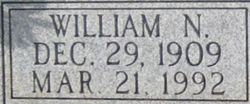


William Newton “Bill” Melton
| Birth | : | 29 Dec 1909 Pryor, Mayes County, Oklahoma, USA |
| Death | : | 21 Mar 1992 Concordia, Cloud County, Kansas, USA |
| Burial | : | Glasco Cemetery, Glasco, Cloud County, USA |
| Coordinate | : | 39.3574000, -97.8265000 |
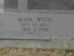
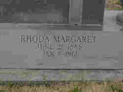
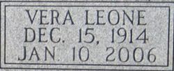
| Description | : | OBITUARY - The Glasco Sun - Glasco, KS William N. "Bill" Melton, 82, Concordia, died Saturday, March 21, 1992, at HCA Wesley Medical Center, Wichita. Mr. Melton was born Dec. 29, 1909 at Pryor, Okla., to Mark and Rhoda Mobley Melton. He moved from Oklahoma with his parents, to the Simpson community in 1912. He was a graduate of Simpson Rural High School. He was married to Vera Leone Overman Oct. 18, 1933 at Concordia and farmed southwest of Concordia from 1939 until retiring in 1962. He was preceded in death by his parents and... Read More |
frequently asked questions (FAQ):
-
Where is William Newton “Bill” Melton's memorial?
William Newton “Bill” Melton's memorial is located at: Glasco Cemetery, Glasco, Cloud County, USA.
-
When did William Newton “Bill” Melton death?
William Newton “Bill” Melton death on 21 Mar 1992 in Concordia, Cloud County, Kansas, USA
-
Where are the coordinates of the William Newton “Bill” Melton's memorial?
Latitude: 39.3574000
Longitude: -97.8265000
Family Members:
Parent
Spouse
Siblings
Flowers:


Nearby Cemetories:
1. Glasco Cemetery
Glasco, Cloud County, USA
Coordinate: 39.3574000, -97.8265000
2. Saint Marys Catholic Cemetery
Glasco, Cloud County, USA
Coordinate: 39.3574000, -97.8245000
3. Simpson Cemetery
Simpson, Mitchell County, USA
Coordinate: 39.3633003, -97.9471970
4. Bethel Cemetery
Meredith Township, Cloud County, USA
Coordinate: 39.3506000, -97.7029000
5. Delphos Cemetery
Delphos, Ottawa County, USA
Coordinate: 39.2778015, -97.7416992
6. Saint Paul Cemetery
Delphos, Ottawa County, USA
Coordinate: 39.2677994, -97.7518997
7. Asherville Cemetery
Asherville, Mitchell County, USA
Coordinate: 39.4205000, -97.9672900
8. Morrison Cemetery
Center Township, Cloud County, USA
Coordinate: 39.4817009, -97.7975006
9. Summit Cemetery
Jamestown, Cloud County, USA
Coordinate: 39.4813200, -97.8628800
10. Green Mound Cemetery
Asherville, Mitchell County, USA
Coordinate: 39.3203011, -97.9858017
11. Coursen Grove Cemetery
Simpson, Mitchell County, USA
Coordinate: 39.3060989, -97.9792023
12. Hall Cemetery
Cloud County, USA
Coordinate: 39.4455986, -97.7033005
13. Saint Peters Cemetery
Miltonvale, Cloud County, USA
Coordinate: 39.3652350, -97.6483570
14. Bell-Bogardus Cemetery
Asherville, Mitchell County, USA
Coordinate: 39.4242410, -97.9919970
15. Bohemian National Cemetery
Ada, Ottawa County, USA
Coordinate: 39.2193870, -97.9054030
16. Wilcox Cemetery
Cloud County, USA
Coordinate: 39.4925003, -97.7313995
17. West Asher Cemetery
Scottsville, Mitchell County, USA
Coordinate: 39.4815000, -97.9661600
18. Baldwin Cemetery
Ottawa County, USA
Coordinate: 39.2061005, -97.9111023
19. Kindel Cemetery
Center Township, Cloud County, USA
Coordinate: 39.4519005, -97.6464005
20. Smith Cemetery
Asherville, Mitchell County, USA
Coordinate: 39.4516690, -98.0098850
21. McBride Cemetery
Beloit, Mitchell County, USA
Coordinate: 39.4808006, -97.9907990
22. Enterprise Cemetery
Cloud County, USA
Coordinate: 39.4230995, -97.6106033
23. Shiloh Cemetery
Beloit, Mitchell County, USA
Coordinate: 39.3574982, -98.0594025
24. Summit Cemetery #3
Macyville, Cloud County, USA
Coordinate: 39.5258330, -97.9194440