
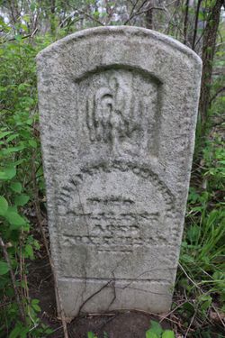
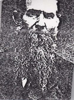
William S. Kennedy
| Birth | : | 18 Feb 1813 Guilford County, North Carolina, USA |
| Death | : | 12 Oct 1889 Nodaway County, Missouri, USA |
| Burial | : | Cheshunt Cemetery, Cheshunt, Broxbourne Borough, England |
| Coordinate | : | 51.7009840, -0.0563720 |
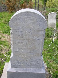
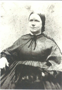
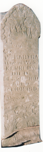
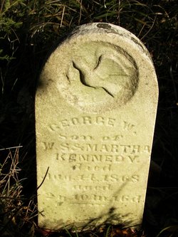
| Description | : | Husband of 1.) Mary Birt, married 8 Oct 1835. Father of six children from this union. Husband of 2.) Martha Noffsinger, married 1860 Nodaway Co., MO. Father of four children. Son of John & Charity (McMichael) Kennedy. |
frequently asked questions (FAQ):
-
Where is William S. Kennedy's memorial?
William S. Kennedy's memorial is located at: Cheshunt Cemetery, Cheshunt, Broxbourne Borough, England.
-
When did William S. Kennedy death?
William S. Kennedy death on 12 Oct 1889 in Nodaway County, Missouri, USA
-
Where are the coordinates of the William S. Kennedy's memorial?
Latitude: 51.7009840
Longitude: -0.0563720
Family Members:
Parent
Spouse
Siblings

Children


Nearby Cemetories:
1. Cheshunt Cemetery
Cheshunt, Broxbourne Borough, England
Coordinate: 51.7009840, -0.0563720
2. St Mary the Virgin Church
Cheshunt, Broxbourne Borough, England
Coordinate: 51.7042420, -0.0489450
3. Adath Yisroel Cemetery
Cheshunt, Broxbourne Borough, England
Coordinate: 51.7015690, -0.0772910
4. Western Synagogue Cemetery
Cheshunt, Broxbourne Borough, England
Coordinate: 51.6850350, -0.0615410
5. St George Churchyard
Freezywater, London Borough of Enfield, England
Coordinate: 51.6738060, -0.0389670
6. Enfield Crematorium
Enfield, London Borough of Enfield, England
Coordinate: 51.6699829, -0.0544380
7. Waltham Abbey
Waltham Abbey, Epping Forest District, England
Coordinate: 51.6876010, -0.0034070
8. St. Laurence Churchyard
Wormley, Broxbourne Borough, England
Coordinate: 51.7352050, -0.0389350
9. Adath Yisroel Cemetery
Enfield, London Borough of Enfield, England
Coordinate: 51.6634740, -0.0669010
10. Waltham Holy Cross-New Cemetery
Waltham Abbey, Epping Forest District, England
Coordinate: 51.6822880, 0.0024510
11. Waltham Holy Cross Old Cemetery
Waltham Abbey, Epping Forest District, England
Coordinate: 51.6823480, 0.0027610
12. Lavender Hill Cemetery
Enfield, London Borough of Enfield, England
Coordinate: 51.6660423, -0.0944350
13. St. James' Churchyard
Enfield, London Borough of Enfield, England
Coordinate: 51.6558850, -0.0470570
14. Hertford Road Cemetery
Enfield, London Borough of Enfield, England
Coordinate: 51.6554120, -0.0449750
15. St Andrew Churchyard
Enfield, London Borough of Enfield, England
Coordinate: 51.6530210, -0.0821420
16. Saint Augustine's Churchyard
Broxbourne, Broxbourne Borough, England
Coordinate: 51.7445150, -0.0147810
17. Waltham Abbey Jewish Cemetery
Waltham Abbey, Epping Forest District, England
Coordinate: 51.6778780, 0.0389240
18. St. Thomas Churchyard
Upshire, Epping Forest District, England
Coordinate: 51.6898890, 0.0465860
19. Quaker Burial Ground, Hoddesdon, Hertfordshire
Hoddesdon, Broxbourne Borough, England
Coordinate: 51.7610213, -0.0139560
20. St Catherine and St Paul's Churchyard
Hoddesdon, Broxbourne Borough, England
Coordinate: 51.7625830, -0.0120670
21. Saint Mary
Bayford, East Hertfordshire District, England
Coordinate: 51.7629540, -0.1035070
22. Holy Innocents Churchyard
High Beach, Epping Forest District, England
Coordinate: 51.6617140, 0.0343380
23. Woollensbrook Crematorium
Hoddesdon, Broxbourne Borough, England
Coordinate: 51.7681805, -0.0280669
24. St. Andrew's Churchyard
Little Berkhamsted, East Hertfordshire District, England
Coordinate: 51.7547390, -0.1295270