
| Memorials | : | 0 |
| Location | : | Hoddesdon, Broxbourne Borough, England |
| Coordinate | : | 51.7610213, -0.0139560 |
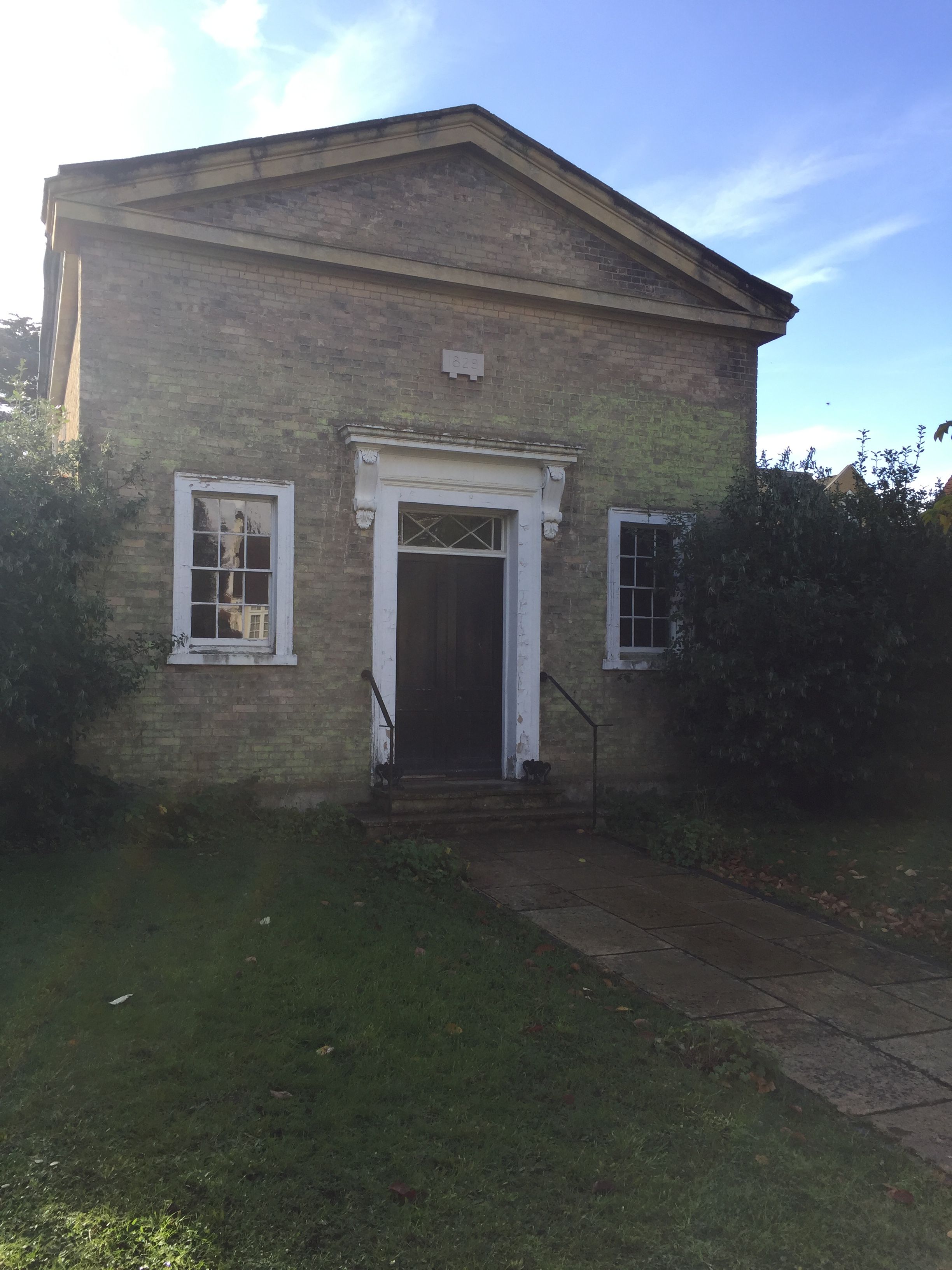
| Description | : | Hoddesdon Society of Friends Meeting House is a Grade II Listed building built in 1828/29 to replace an earlier Meeting House in Marsh Lane, Hoddesdon (now Essex Road) opened in 1697. The new Lord Street premises were designed by Friend William Alderson of Chelsea and a small burial ground was attached to the rear, with the gravestones being of simple design as reflected the lifestyle of the Quakers. Details of the history and architectural features of the building can be found in the recent report by Historic England at https://historicengland.org.uk/listing/the-list/list-entry/1100502. Although the building is no longer used for worship, the Hoddesdon... Read More |
frequently asked questions (FAQ):
-
Where is Quaker Burial Ground, Hoddesdon, Hertfordshire?
Quaker Burial Ground, Hoddesdon, Hertfordshire is located at Lord Street, Hoddesdon, Hertfordshire Hoddesdon, Broxbourne Borough ,Hertfordshire , EN11 8NEEngland.
-
Quaker Burial Ground, Hoddesdon, Hertfordshire cemetery's updated grave count on graveviews.com?
0 memorials
-
Where are the coordinates of the Quaker Burial Ground, Hoddesdon, Hertfordshire?
Latitude: 51.7610213
Longitude: -0.0139560
Nearby Cemetories:
1. St Catherine and St Paul's Churchyard
Hoddesdon, Broxbourne Borough, England
Coordinate: 51.7625830, -0.0120670
2. Hoddesdon Cemetery
Hoddesdon, Broxbourne Borough, England
Coordinate: 51.7711490, -0.0156822
3. Woollensbrook Crematorium
Hoddesdon, Broxbourne Borough, England
Coordinate: 51.7681805, -0.0280669
4. Saint Augustine's Churchyard
Broxbourne, Broxbourne Borough, England
Coordinate: 51.7445150, -0.0147810
5. St. Margaret's Parish Churchyard
Stanstead St Margarets, East Hertfordshire District, England
Coordinate: 51.7857570, -0.0002631
6. St. Laurence Churchyard
Wormley, Broxbourne Borough, England
Coordinate: 51.7352050, -0.0389350
7. Holy Trinity Churchyard
Hertford Heath, East Hertfordshire District, England
Coordinate: 51.7865300, -0.0433980
8. St James' Churchyard
Stanstead Abbotts, East Hertfordshire District, England
Coordinate: 51.7806920, 0.0275950
9. St John the Baptist Churchyard
Great Amwell, East Hertfordshire District, England
Coordinate: 51.7944320, -0.0123740
10. Roydon United Reform Churchyard
Roydon, Epping Forest District, England
Coordinate: 51.7714050, 0.0460240
11. All Saints Churchyard
Nazeing, Epping Forest District, England
Coordinate: 51.7436140, 0.0464100
12. All Saints with Saint John Churchyard
Hertford, East Hertfordshire District, England
Coordinate: 51.7950040, -0.0757330
13. Saint Mary's Churchyard
Ware, East Hertfordshire District, England
Coordinate: 51.8120500, -0.0331800
14. The Immaculate Conception and St Joseph
Hertford, East Hertfordshire District, England
Coordinate: 51.7988966, -0.0745293
15. St Mary the Virgin Churchyard
Great Parndon, Harlow District, England
Coordinate: 51.7605100, 0.0739860
16. St. Dunstan Churchyard
Hunsdon, East Hertfordshire District, England
Coordinate: 51.7951000, 0.0548190
17. Saint Andrew Churchyard
Hertford, East Hertfordshire District, England
Coordinate: 51.7960550, -0.0823520
18. Saint Mary
Bayford, East Hertfordshire District, England
Coordinate: 51.7629540, -0.1035070
19. St. Leonard's Churchyard
Bengeo, East Hertfordshire District, England
Coordinate: 51.8055165, -0.0722084
20. Ware Cemetery Old
Ware, East Hertfordshire District, England
Coordinate: 51.8170650, -0.0433230
21. Ware Cemetery New
Ware, East Hertfordshire District, England
Coordinate: 51.8181400, -0.0438590
22. Holy Trinity Churchyard
Bengeo, East Hertfordshire District, England
Coordinate: 51.8053500, -0.0798610
23. St Mary the Virgin Church
Cheshunt, Broxbourne Borough, England
Coordinate: 51.7042420, -0.0489450
24. St Botolph Church
Eastwick, East Hertfordshire District, England
Coordinate: 51.7851000, 0.0776000