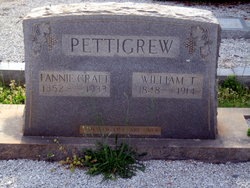
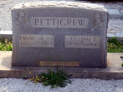
William Thomas Capers Pettigrew
| Birth | : | 1848 Clatworthy Crossroads, Abbeville County, South Carolina, USA |
| Death | : | 1914 Clatworthy Crossroads, Abbeville County, South Carolina, USA |
| Burial | : | Bethia Cemetery, Clatworthy Crossroads, Abbeville County, USA |
| Coordinate | : | 34.0617810, -82.3759150 |
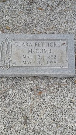
| Description | : | As the Civil War drew to a close, seventeen-year-old William Thomas Capers Pettigrew and his twin brother James Orr Andrew Pettigrew joined the ranks of the Confederacy's "boy soldiers" and marched away to defend their homeland. Named for William Thomas Capers, the mid-nineteenth century Bishop of the Anderson (SC) District of the Methodist Episcopal Church (South), W. T. C. Pettigrew survived the war, returned home, married Millie Frances (Fanny) Craft, and reared a family that included my maternal grandmother, Martha (Mattie) Clara Pettigrew McComb (_q. v.). Named for former South Carolina Governor James Orr, J. O. A. Pettigrew... Read More |
frequently asked questions (FAQ):
-
Where is William Thomas Capers Pettigrew's memorial?
William Thomas Capers Pettigrew's memorial is located at: Bethia Cemetery, Clatworthy Crossroads, Abbeville County, USA.
-
When did William Thomas Capers Pettigrew death?
William Thomas Capers Pettigrew death on 1914 in Clatworthy Crossroads, Abbeville County, South Carolina, USA
-
Where are the coordinates of the William Thomas Capers Pettigrew's memorial?
Latitude: 34.0617810
Longitude: -82.3759150
Family Members:
Spouse
Children
Flowers:
Nearby Cemetories:
1. Bethia Cemetery
Clatworthy Crossroads, Abbeville County, USA
Coordinate: 34.0617810, -82.3759150
2. Saint Goodwill Baptist Church Cemetery
McCormick County, USA
Coordinate: 34.0419720, -82.3831670
3. Little Mountain African Methodist Episcopal Church
Abbeville, Abbeville County, USA
Coordinate: 34.0842820, -82.3758020
4. Chapel Cemetery
McCormick County, USA
Coordinate: 34.0388985, -82.3569031
5. Glover Chapel Baptist Church Cemetery
McCormick County, USA
Coordinate: 34.0356080, -82.3615130
6. Chisholm Cemetery
McCormick County, USA
Coordinate: 34.0283012, -82.3688965
7. William Vickery Family
McCormick County, USA
Coordinate: 34.0282220, -82.3693130
8. Glasgow Family Cemetery
McCormick County, USA
Coordinate: 34.0307500, -82.3938333
9. Reid Cemetery
Calhoun Falls, Abbeville County, USA
Coordinate: 34.0653333, -82.4236167
10. Hopewell Presbyterian Church
Mount Carmel, McCormick County, USA
Coordinate: 34.0391650, -82.4174590
11. Poplar Grove Baptist Church Cemetery
Abbeville County, USA
Coordinate: 34.0882100, -82.3312400
12. Ritchie Cemetery
Abbeville County, USA
Coordinate: 34.0758800, -82.4301200
13. Saint Mary A. M. E. Cemetery
Mount Carmel, McCormick County, USA
Coordinate: 34.0229400, -82.3424970
14. Neel Cemetery
Abbeville County, USA
Coordinate: 34.0686300, -82.4337200
15. Tittle Cemetery
Bradley Corner, McCormick County, USA
Coordinate: 34.0325400, -82.3258800
16. Lower Long Cane Cemetery
McCormick County, USA
Coordinate: 34.0158005, -82.3491974
17. Walnut Grove Baptist Church
Abbeville County, USA
Coordinate: 34.0996990, -82.4272550
18. Calhoun Cemetery
Abbeville County, USA
Coordinate: 34.0619011, -82.4458008
19. Mulberry African Methodist Episcopal Church Cemete
Abbeville, Abbeville County, USA
Coordinate: 34.0633640, -82.4477310
20. Rock Buffalo Baptist Church Cemetery
Abbeville, Abbeville County, USA
Coordinate: 34.1223770, -82.3793010
21. Cedar Springs A.R.P. Church Cemetery
Greenwood County, USA
Coordinate: 34.0792400, -82.3025300
22. Lee Cemetery
McCormick County, USA
Coordinate: 34.0263800, -82.4396900
23. Lebanon Presbyterian Church Cemetery
Abbeville County, USA
Coordinate: 34.1149930, -82.4181590
24. Lebanon Church Enslaved Persons Burial Site
Abbeville County, USA
Coordinate: 34.1151470, -82.4192810

