
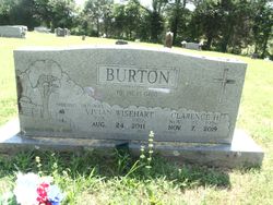
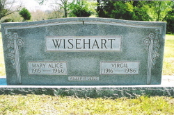
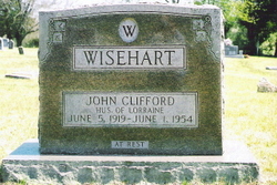
Wilma Vivian Wisehart Burton
| Birth | : | 2 Feb 1926 Myrtle, Oregon County, Missouri, USA |
| Death | : | 21 Aug 2011 West Plains, Howell County, Missouri, USA |
| Burial | : | Myrtle Cemetery, Myrtle, Oregon County, USA |
| Coordinate | : | 36.5133900, -91.2664300 |
| Description | : | Funeral services for Wilma Vivian Burton, 85, West Plains, will be held Wednesday, August 24, 2011, at the United Freewill Baptist Church under the direction of Robertson-Drago Funeral Home. Mrs. Burton died 7:26 p.m. Sunday, August 21, 2011 at Brooke Haven Healthcare. She was born February 2, 1926, at Myrtle, MO to Roy J. and Ollie Crass Wisehart. In 1943, she graduated from Couch High School, and on March 4, 1950, she was married at Myrtle, MO to Clarence Burton. Before her retirement, Mrs. Burton had been employed with the Missouri State Association of the Freewill Baptist Church. She was a member of... Read More |
frequently asked questions (FAQ):
-
Where is Wilma Vivian Wisehart Burton's memorial?
Wilma Vivian Wisehart Burton's memorial is located at: Myrtle Cemetery, Myrtle, Oregon County, USA.
-
When did Wilma Vivian Wisehart Burton death?
Wilma Vivian Wisehart Burton death on 21 Aug 2011 in West Plains, Howell County, Missouri, USA
-
Where are the coordinates of the Wilma Vivian Wisehart Burton's memorial?
Latitude: 36.5133900
Longitude: -91.2664300
Family Members:
Parent

Spouse
Siblings


Nearby Cemetories:
1. Myrtle Cemetery
Myrtle, Oregon County, USA
Coordinate: 36.5133900, -91.2664300
2. Church of God Cemetery
Oregon County, USA
Coordinate: 36.5023500, -91.2580200
3. Byrd Cemetery
Myrtle, Oregon County, USA
Coordinate: 36.5186005, -91.3143997
4. Crass Homestead
Myrtle, Oregon County, USA
Coordinate: 36.5359695, -91.3084671
5. Old Elmore Thomas field
Billmore, Oregon County, USA
Coordinate: 36.5237770, -91.1980250
6. Spring Valley Cemetery
Billmore, Oregon County, USA
Coordinate: 36.5324670, -91.2003420
7. Guiteau-Risner Cemetery
Guiteau, Oregon County, USA
Coordinate: 36.5588074, -91.3156128
8. Walnut Grove Cemetery
Elm Store, Randolph County, USA
Coordinate: 36.4914017, -91.1967010
9. O'Neal
Billmore, Oregon County, USA
Coordinate: 36.5712170, -91.2415410
10. Cotton Creek Cemetery
Jobe, Oregon County, USA
Coordinate: 36.5844002, -91.2652969
11. John Brown Cemetery
Jobe, Oregon County, USA
Coordinate: 36.5812111, -91.2953568
12. James Cemetery
Randolph County, USA
Coordinate: 36.4660988, -91.3435974
13. Old Jobe Cemetery
Jobe, Oregon County, USA
Coordinate: 36.5917015, -91.2517014
14. Mount Carmel Cemetery
Calm, Oregon County, USA
Coordinate: 36.5106010, -91.1643982
15. Taylor Cemetery
Ravenden Springs, Randolph County, USA
Coordinate: 36.4468994, -91.3293991
16. Garfield Cemetery
Garfield, Oregon County, USA
Coordinate: 36.5844400, -91.3253400
17. Mosely Cemetery
Randolph County, USA
Coordinate: 36.4460983, -91.1975021
18. Davis Cemetery
Sharp County, USA
Coordinate: 36.4606018, -91.3574982
19. Reynolds Cemetery
Elm Store, Randolph County, USA
Coordinate: 36.4491997, -91.1860962
20. Pigman Mound Archeological Site
Calm, Oregon County, USA
Coordinate: 36.5717100, -91.1784800
21. Stubblefield Cemetery
Dalton, Randolph County, USA
Coordinate: 36.4597015, -91.1718979
22. Bellah Cemetery
Ravenden Springs, Randolph County, USA
Coordinate: 36.4207993, -91.2825012
23. Arytown Cemetery
Arytown, Oregon County, USA
Coordinate: 36.5539513, -91.3795776
24. Liberty Cemetery
Calm, Oregon County, USA
Coordinate: 36.5586500, -91.1549600