
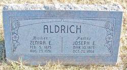
Zenira Eugenia Fergus Aldrich
| Birth | : | 5 Feb 1875 Cookeville, Putnam County, Tennessee, USA |
| Death | : | 23 Aug 1951 Stafford, Stafford County, Kansas, USA |
| Burial | : | Shields Cemetery, Clay County, USA |
| Coordinate | : | 39.3208008, -97.3507996 |
| Description | : | Obituary from the Hutchinson News-Herald, 8/24/1951: Mrs. J.E. Aldrich Sylvia - Mrs. Zenira Eugenia Aldrich died at 2:30 am Thursday in a Stafford hospital, after a long illness. She was born Feb. 5, 1875 in Cooksville, Tenn. She had lived 53 years in the Sylvia community. Survivors are her widower, J.E. Aldrick [sic] of the home; four sons, Vernon, Hutchinson; Earl, Sylvia; Edward, Herington and Charles, Enterprise; two daughters, Mrs. Margaret Walters, Herington and Mrs. Pearl Wheeler, Wichita; a sister, Mrs. O.S. Waddle, Macksville; three brothers, Will Fergus, Santa Ana, Cal., Sam Fergus, St. John and... Read More |
frequently asked questions (FAQ):
-
Where is Zenira Eugenia Fergus Aldrich's memorial?
Zenira Eugenia Fergus Aldrich's memorial is located at: Shields Cemetery, Clay County, USA.
-
When did Zenira Eugenia Fergus Aldrich death?
Zenira Eugenia Fergus Aldrich death on 23 Aug 1951 in Stafford, Stafford County, Kansas, USA
-
Where are the coordinates of the Zenira Eugenia Fergus Aldrich's memorial?
Latitude: 39.3208008
Longitude: -97.3507996
Family Members:
Spouse

Children

Flowers:


Nearby Cemetories:
1. Shields Cemetery
Clay County, USA
Coordinate: 39.3208008, -97.3507996
2. Table Mound Cemetery
Idana, Clay County, USA
Coordinate: 39.3141300, -97.2792300
3. Hebron Cemetery
Clay County, USA
Coordinate: 39.3213800, -97.2601400
4. Idana Cemetery
Idana, Clay County, USA
Coordinate: 39.3574500, -97.2693300
5. Miltonvale Cemetery
Miltonvale, Cloud County, USA
Coordinate: 39.3358002, -97.4447021
6. Smith Grave
Miltonvale, Cloud County, USA
Coordinate: 39.3645300, -97.4308700
7. Pleasant Valley Cemetery
Oak Hill, Clay County, USA
Coordinate: 39.2468987, -97.2889023
8. Mount Liberty Church Cemetery
Ottawa County, USA
Coordinate: 39.2489400, -97.4356200
9. Rose Meron Cemetery
Oak Hill, Clay County, USA
Coordinate: 39.2194700, -97.3338900
10. Lincoln Cemetery
Clay Center, Clay County, USA
Coordinate: 39.4230995, -97.2930984
11. Wesleyan Cemetery
Oak Hill, Clay County, USA
Coordinate: 39.2268982, -97.2572021
12. French Presbyterian Church Cemetery
Cloud County, USA
Coordinate: 39.4395200, -97.4148290
13. Iwacura Cemetery
Morganville, Clay County, USA
Coordinate: 39.4550000, -97.3510000
14. Pleasant Ridge Cemetery
Clay County, USA
Coordinate: 39.2789001, -97.1841965
15. Wilson Cemetery
Clay County, USA
Coordinate: 39.3800011, -97.1896973
16. Fairview Cemetery
Lamar, Ottawa County, USA
Coordinate: 39.2928009, -97.5299988
17. Bloom Cemetery
Morganville, Clay County, USA
Coordinate: 39.4519005, -97.2778015
18. Sulphur Springs Cemetery
Aurora, Cloud County, USA
Coordinate: 39.4086610, -97.4986840
19. Republican City Cemetery
Clay Center, Clay County, USA
Coordinate: 39.3431015, -97.1628036
20. Zion Lutheran Cemetery
Clay County, USA
Coordinate: 39.2928009, -97.1557999
21. Thomas Cemetery
Miltonvale, Cloud County, USA
Coordinate: 39.3300000, -97.5750000
22. Oakland Union Cemetery
Miltonvale, Cloud County, USA
Coordinate: 39.3647003, -97.5824966
23. Princeville Cemetery
Aurora, Cloud County, USA
Coordinate: 39.4672012, -97.5010986
24. Swartwood Cemetery
Longford, Clay County, USA
Coordinate: 39.1323200, -97.3431500