
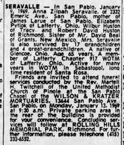
Zilpah Anna Beal Seravalle
| Birth | : | 3 Dec 1903 Glencoe, Belmont County, Ohio, USA |
| Death | : | 9 Jan 1969 Richmond, Contra Costa County, California, USA |
| Burial | : | Rolling Hills Memorial Park, Richmond, Contra Costa County, USA |
| Coordinate | : | 37.9756012, -122.3146973 |
| Plot | : | Garden of Devotion, Lot 716, Space 2 |
| Description | : | According to a photograph volunteer the cemetery office has confirmed that this burial is unmarked. The grave is owned by her son, James LaRue. No other family members are interred with or around her. |
frequently asked questions (FAQ):
-
Where is Zilpah Anna Beal Seravalle's memorial?
Zilpah Anna Beal Seravalle's memorial is located at: Rolling Hills Memorial Park, Richmond, Contra Costa County, USA.
-
When did Zilpah Anna Beal Seravalle death?
Zilpah Anna Beal Seravalle death on 9 Jan 1969 in Richmond, Contra Costa County, California, USA
-
Where are the coordinates of the Zilpah Anna Beal Seravalle's memorial?
Latitude: 37.9756012
Longitude: -122.3146973
Family Members:
Parent

Spouse
Siblings
Children
Flowers:


Nearby Cemetories:
1. Rolling Hills Memorial Park
Richmond, Contra Costa County, USA
Coordinate: 37.9756012, -122.3146973
2. Saint Joseph Catholic Cemetery
San Pablo, Contra Costa County, USA
Coordinate: 37.9612700, -122.3336600
3. Saint Pauls Cemetery (Defunct)
San Pablo, Contra Costa County, USA
Coordinate: 37.9563332, -122.3430099
4. Salesian Cemetery
Richmond, Contra Costa County, USA
Coordinate: 37.9532650, -122.3401230
5. Sunset View Cemetery
El Cerrito, Contra Costa County, USA
Coordinate: 37.9077721, -122.2871017
6. Golden Gate Mausoleum and Columbaria
El Cerrito, Contra Costa County, USA
Coordinate: 37.9073150, -122.2857220
7. Golden Gate Fields
Albany, Alameda County, USA
Coordinate: 37.8854000, -122.3117000
8. Northbrae Community Church Columbarium
Berkeley, Alameda County, USA
Coordinate: 37.8905500, -122.2763200
9. Gan Shalom Cemetery
Contra Costa County, USA
Coordinate: 37.9528122, -122.1975098
10. Rags Gravesite
Crockett, Contra Costa County, USA
Coordinate: 38.0561765, -122.2257217
11. Mare Island Cemetery
Vallejo, Solano County, USA
Coordinate: 38.0796738, -122.2527008
12. Glen Cove Sacred Indian Burial Grounds
Vallejo, Solano County, USA
Coordinate: 38.0680620, -122.2064640
13. Saint Stephens Episcopal Church Memorial Garden
Orinda, Contra Costa County, USA
Coordinate: 37.8982650, -122.1729170
14. Carquinez Cemetery
Vallejo, Solano County, USA
Coordinate: 38.0889015, -122.2108002
15. Saint Vincents Cemetery
Vallejo, Solano County, USA
Coordinate: 38.0881004, -122.2089005
16. Saint Catherine of Siena Cemetery
Martinez, Contra Costa County, USA
Coordinate: 38.0172005, -122.1446991
17. All Souls Catholic Cemetery
Vallejo, Solano County, USA
Coordinate: 38.0881690, -122.2077890
18. San Quentin Prison Cemetery
San Rafael, Marin County, USA
Coordinate: 37.9436480, -122.4883760
19. Alhambra Cemetery
Martinez, Contra Costa County, USA
Coordinate: 38.0182991, -122.1442032
20. Skyview Memorial Lawn
Vallejo, Solano County, USA
Coordinate: 38.0920460, -122.2080320
21. Angel Island Cemetery (defunct)
Tiburon, Marin County, USA
Coordinate: 37.8621830, -122.4325920
22. Hillside Cemetery
Vallejo, Solano County, USA
Coordinate: 38.1185989, -122.2647018
23. Sunrise Memorial Cemetery
Vallejo, Solano County, USA
Coordinate: 38.1194000, -122.2605972
24. Lafayette-Orinda Presbyterian Church Garden
Contra Costa County, USA
Coordinate: 37.8866040, -122.1606950