
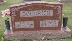
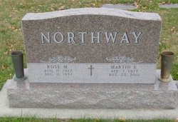
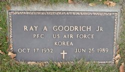
Zilpha Wilma Stubbs Goodrich
| Birth | : | 28 Jun 1895 Warren County, Iowa, USA |
| Death | : | 3 Jun 1984 Osceola, Clarke County, Iowa, USA |
| Burial | : | Mount Pleasant Wesleyan Chapelyard, Bacup, Rossendale Borough, England |
| Coordinate | : | 53.6924900, -2.2228100 |
| Plot | : | Section - Pleasant Hill, Row 16, Grave 20. |
frequently asked questions (FAQ):
-
Where is Zilpha Wilma Stubbs Goodrich's memorial?
Zilpha Wilma Stubbs Goodrich's memorial is located at: Mount Pleasant Wesleyan Chapelyard, Bacup, Rossendale Borough, England.
-
When did Zilpha Wilma Stubbs Goodrich death?
Zilpha Wilma Stubbs Goodrich death on 3 Jun 1984 in Osceola, Clarke County, Iowa, USA
-
Where are the coordinates of the Zilpha Wilma Stubbs Goodrich's memorial?
Latitude: 53.6924900
Longitude: -2.2228100
Family Members:

Spouse

Siblings
Children
Flowers:


Nearby Cemetories:
1. Mount Pleasant Wesleyan Chapelyard
Bacup, Rossendale Borough, England
Coordinate: 53.6924900, -2.2228100
2. Bacup Cemetery
Bacup, Rossendale Borough, England
Coordinate: 53.6906780, -2.2156640
3. St John the Evangelist Churchyard
Bacup, Rossendale Borough, England
Coordinate: 53.7037300, -2.2019600
4. Newchurch Methodist Churchyard
Newchurch, Rossendale Borough, England
Coordinate: 53.6983460, -2.2501260
5. St. Nicholas Churchyard
Newchurch, Rossendale Borough, England
Coordinate: 53.6972220, -2.2524660
6. Bethlehem Chapel Graveyard
Newchurch, Rossendale Borough, England
Coordinate: 53.6976970, -2.2522620
7. Ebenezer Particular Baptist Chapel Chapelyard
Bacup, Rossendale Borough, England
Coordinate: 53.7045700, -2.1997500
8. Saint Anne's Churchyard Edgeside
Waterfoot, Rossendale Borough, England
Coordinate: 53.7031600, -2.2482700
9. Saint Michael on the Hill Churchyard
Lumb, Rossendale Borough, England
Coordinate: 53.7201000, -2.2479300
10. Lumb Baptist Church Cemetery
Waterfoot, Rossendale Borough, England
Coordinate: 53.7229340, -2.2455170
11. Friends Burial Ground
Rossendale, Rossendale Borough, England
Coordinate: 53.7091000, -2.2757160
12. Unitarian Chapel Burial Ground
Rossendale, Rossendale Borough, England
Coordinate: 53.7024380, -2.2856290
13. Longholme Methodist Cemetery
Rawtenstall, Rossendale Borough, England
Coordinate: 53.7009730, -2.2865000
14. Rawtenstall Cemetery
Rawtenstall, Rossendale Borough, England
Coordinate: 53.7060200, -2.2847500
15. Whitworth Cemetery
Whitworth, Rossendale Borough, England
Coordinate: 53.6671650, -2.1674750
16. Broadleys Garden
Rawtenstall, Rossendale Borough, England
Coordinate: 53.7176321, -2.2904764
17. Burnley Road Cemetery, Reedsholme, Rossendale
Rossendale Borough, England
Coordinate: 53.7178398, -2.2904316
18. St Bartholomew Churchyard
Whitworth, Rossendale Borough, England
Coordinate: 53.6553000, -2.1709700
19. Crawshawbooth Quaker Burial Ground
Crawshawbooth, Rossendale Borough, England
Coordinate: 53.7242420, -2.2879400
20. St. Mary and All Saints Churchyard
Goodshaw, Rossendale Borough, England
Coordinate: 53.7315270, -2.2828940
21. Edenfield Parish Churchyard
Ramsbottom, Metropolitan Borough of Bury, England
Coordinate: 53.6742799, -2.3069304
22. Goodshaw Particular Baptist Chapel Graveyard
Goodshaw, Rossendale Borough, England
Coordinate: 53.7328210, -2.2815530
23. Cloughfoot Independent Congregational Chapelyard
Todmorden, Metropolitan Borough of Calderdale, England
Coordinate: 53.7113850, -2.1379180
24. Rehoboth Chapel
Goodshaw, Rossendale Borough, England
Coordinate: 53.7355870, -2.2914730