
| Memorials | : | 0 |
| Location | : | New Franklin, Howard County, USA |
| Coordinate | : | 39.0033210, -92.6126350 |
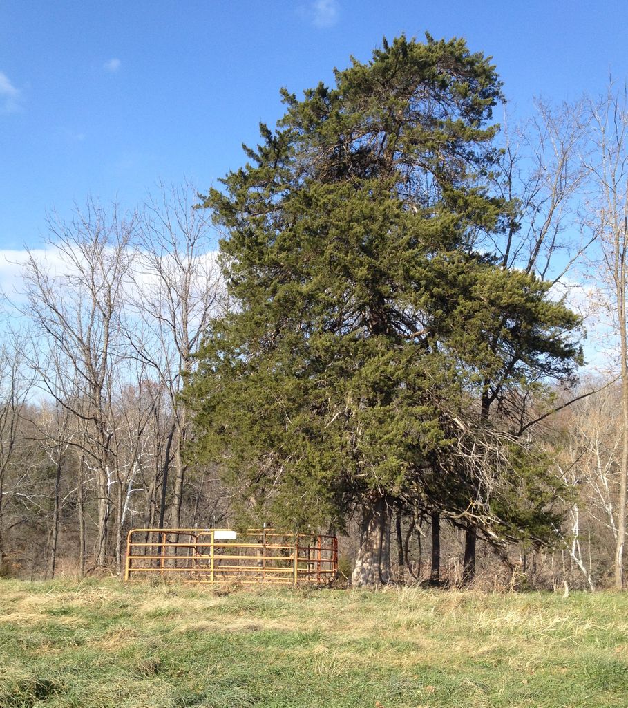
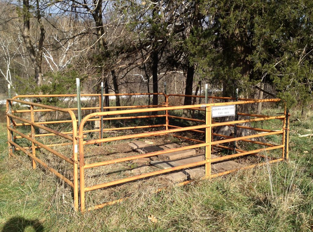
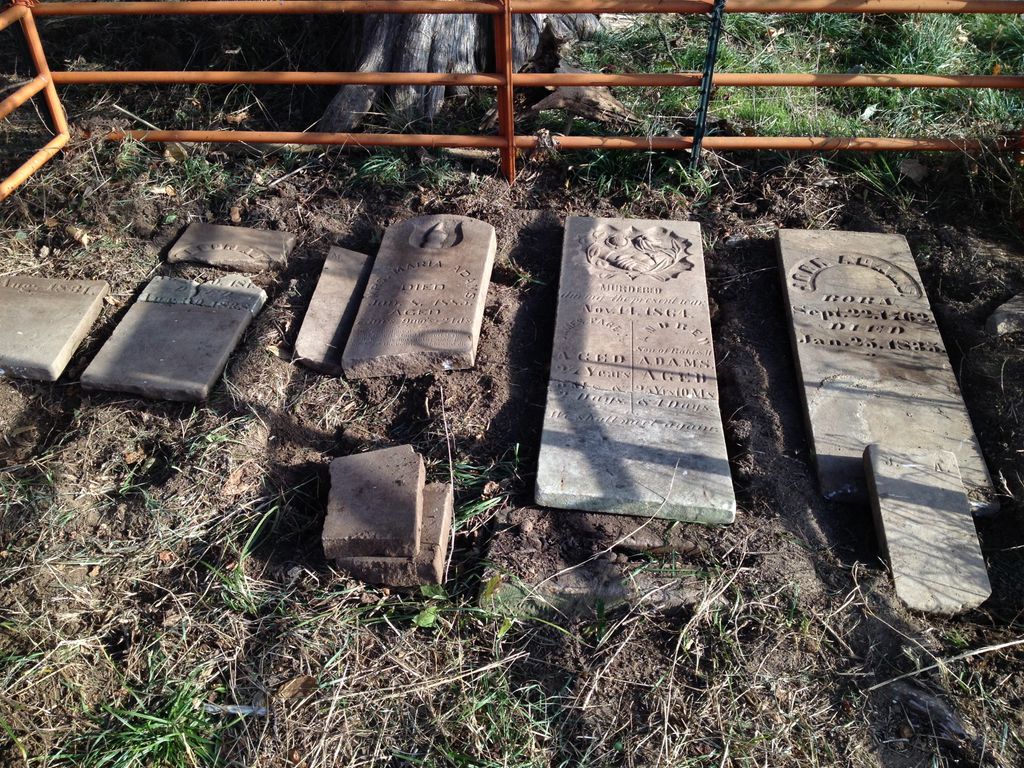
| Description | : | The Adams Cemetery is on land originally homesteaded by John Adams (1762-1835), who is buried there. It is just south of County Road 442 (road visible on cemetery photo) on private property now owned by James Renfro. For access, contact James Renfro, 1543 County Road 442, New Franklin, MO 65274, (573)698-2042. The cemetery lies under a large Juniper tree, and the gravestones had been broken and strewn by cattle when it was found by Adams descendant Verne Hoffman in 1997. In November 1997, the stones were collected and a steel fence 16 feet square was installed by Verne and... Read More |
frequently asked questions (FAQ):
-
Where is Adams Cemetery?
Adams Cemetery is located at New Franklin, Howard County ,Missouri ,USA.
-
Adams Cemetery cemetery's updated grave count on graveviews.com?
0 memorials
-
Where are the coordinates of the Adams Cemetery?
Latitude: 39.0033210
Longitude: -92.6126350
Nearby Cemetories:
1. Sulphur Springs Cemetery
New Franklin, Howard County, USA
Coordinate: 39.0053368, -92.6174850
2. Jennings Cemetery
Howard County, USA
Coordinate: 39.0157160, -92.6355600
3. Shaw Cemetery
Howard County, USA
Coordinate: 39.0321530, -92.6183940
4. Drake-Campbell Cemetery
Howard County, USA
Coordinate: 39.0307999, -92.6502991
5. Robinson Cemetery
Howard County, USA
Coordinate: 39.0264015, -92.6596985
6. Ashland Cemetery
Fayette, Howard County, USA
Coordinate: 39.0495200, -92.6222900
7. Rocheport City Cemetery
Rocheport, Boone County, USA
Coordinate: 38.9809050, -92.5590420
8. Schmidt Cemetery
Wooldridge, Cooper County, USA
Coordinate: 38.9500008, -92.6046982
9. Big Springs Christian Church Cemetery
Hilldale, Howard County, USA
Coordinate: 39.0328598, -92.5495834
10. Salt Creek Cemetery
Howard County, USA
Coordinate: 39.0474280, -92.6628770
11. Hourigan Cemetery
Howard County, USA
Coordinate: 39.0558014, -92.5622025
12. Clayton Cemetery
Overton, Cooper County, USA
Coordinate: 38.9427986, -92.5744019
13. Mount Woodland African Methodist Episcopal Church
Hilldale, Howard County, USA
Coordinate: 39.0601980, -92.5632510
14. Walnut Grove Cemetery
Rocheport, Boone County, USA
Coordinate: 39.0125008, -92.5233002
15. Yahweh's Assembly In Messiah Cemetery
Rocheport, Boone County, USA
Coordinate: 38.9611995, -92.5397969
16. Old Bethel Cemetery
Midway, Boone County, USA
Coordinate: 39.0414200, -92.5198800
17. Lientz Cemetery
Midway, Boone County, USA
Coordinate: 39.0080400, -92.5050200
18. Hail Ridge Cemetery
Boonville, Cooper County, USA
Coordinate: 38.9394444, -92.6941667
19. Missouri Boys Training School Cemetery
Boonville, Cooper County, USA
Coordinate: 38.9732120, -92.7297190
20. Boonville Memorial Gardens Cemetery
Boonville, Cooper County, USA
Coordinate: 38.9670460, -92.7271950
21. Saint Peter and Paul Catholic Cemetery
Boonville, Cooper County, USA
Coordinate: 38.9730060, -92.7306800
22. Walnut Grove Cemetery
Boonville, Cooper County, USA
Coordinate: 38.9713783, -92.7324524
23. Mount Zion Cemetery
Howard County, USA
Coordinate: 39.0916300, -92.6754700
24. Ricketts Cemetery
Howard County, USA
Coordinate: 39.1046982, -92.6007996