
| Memorials | : | 0 |
| Location | : | Hilldale, Howard County, USA |
| Coordinate | : | 39.0601980, -92.5632510 |
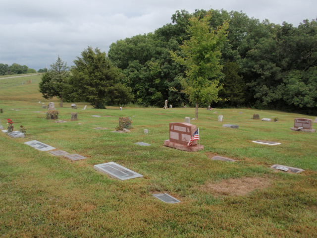
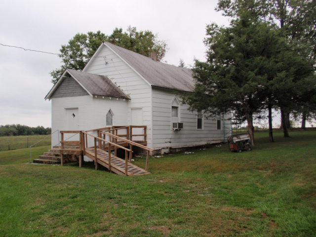
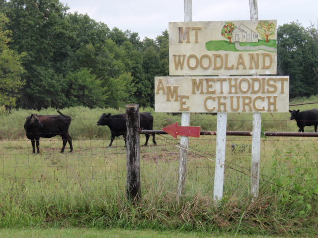
| Description | : | Mount Woodland African Methodist Episcopal Church Cemetery is also known as Hilldale Cemetery, Hillsdale Cemetery, Woodland Cemetery, and Mt Woodland Cemetery on death certificates and in obituaries. From I-70, just west of Columbia, Missouri, take Highway 40 West (Exit 121). Turn right (north) onto Route J. Turn left (northwest) onto Route EE. Turn left onto County Road 429 and go 0.3 miles. The church and cemetery will be on your left. Hilldale was an unincorporated community in Moniteau Township, Howard County, Missouri. It was named for a hill and dale near the original town site. The church site is currently marked... Read More |
frequently asked questions (FAQ):
-
Where is Mount Woodland African Methodist Episcopal Church?
Mount Woodland African Methodist Episcopal Church is located at Hilldale, Howard County ,Missouri ,USA.
-
Mount Woodland African Methodist Episcopal Church cemetery's updated grave count on graveviews.com?
0 memorials
-
Where are the coordinates of the Mount Woodland African Methodist Episcopal Church?
Latitude: 39.0601980
Longitude: -92.5632510
Nearby Cemetories:
1. Hourigan Cemetery
Howard County, USA
Coordinate: 39.0558014, -92.5622025
2. Big Springs Christian Church Cemetery
Hilldale, Howard County, USA
Coordinate: 39.0328598, -92.5495834
3. Old Bethel Cemetery
Midway, Boone County, USA
Coordinate: 39.0414200, -92.5198800
4. Smith Chapel Church Cemetery
Fayette, Howard County, USA
Coordinate: 39.0897590, -92.5187931
5. Ashland Cemetery
Fayette, Howard County, USA
Coordinate: 39.0495200, -92.6222900
6. Shaw Cemetery
Howard County, USA
Coordinate: 39.0321530, -92.6183940
7. Ricketts Cemetery
Howard County, USA
Coordinate: 39.1046982, -92.6007996
8. Cowden Family Cemetery
Woodlandville, Boone County, USA
Coordinate: 39.0598300, -92.4919100
9. Walnut Grove Cemetery
Rocheport, Boone County, USA
Coordinate: 39.0125008, -92.5233002
10. Adams Cemetery
New Franklin, Howard County, USA
Coordinate: 39.0033210, -92.6126350
11. Lientz Cemetery
Midway, Boone County, USA
Coordinate: 39.0080400, -92.5050200
12. Sulphur Springs Cemetery
New Franklin, Howard County, USA
Coordinate: 39.0053368, -92.6174850
13. Jennings Cemetery
Howard County, USA
Coordinate: 39.0157160, -92.6355600
14. Drake-Campbell Cemetery
Howard County, USA
Coordinate: 39.0307999, -92.6502991
15. Evert Church Cemetery
Woodlandville, Boone County, USA
Coordinate: 39.0615160, -92.4631690
16. Salt Creek Cemetery
Howard County, USA
Coordinate: 39.0474280, -92.6628770
17. Barnes Cemetery
Howard County, USA
Coordinate: 39.1268997, -92.5093994
18. Rocheport City Cemetery
Rocheport, Boone County, USA
Coordinate: 38.9809050, -92.5590420
19. Robinson Cemetery
Howard County, USA
Coordinate: 39.0264015, -92.6596985
20. Givens Cemetery
Howard County, USA
Coordinate: 39.1399994, -92.5378036
21. Old Cemetery
Howard County, USA
Coordinate: 39.1431007, -92.6016998
22. Mount Gilead Cemetery
Fayette, Howard County, USA
Coordinate: 39.1430726, -92.6022755
23. Manion Cemetery
Howard County, USA
Coordinate: 39.1385994, -92.6205978
24. Mount Zion Cemetery
Howard County, USA
Coordinate: 39.0916300, -92.6754700