
| Memorials | : | 0 |
| Location | : | Midway, Boone County, USA |
| Coordinate | : | 39.0414200, -92.5198800 |
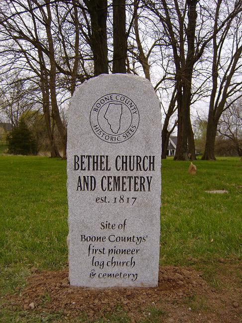
| Description | : | Old Bethel Baptist Church was built in 1817. The Church & Cemetery are both extinct. Local folklore speculates the church was burned during the Civil War. The site is located in what is now known as Sycamore Creek Subdivision, located south-west of Woodlandville & north-west of Midway. This decades-dormant cemetery was discovered in 1974 by developer, Ron Westenhaver, as he began developing the Sycamore Creek subdivision, he did not allow any homes to be built on the actual site. Currently there are only nine (9) known burials in Bethel Cemetery, it is unknown as to how... Read More |
frequently asked questions (FAQ):
-
Where is Old Bethel Cemetery?
Old Bethel Cemetery is located at Midway, Boone County ,Missouri ,USA.
-
Old Bethel Cemetery cemetery's updated grave count on graveviews.com?
0 memorials
-
Where are the coordinates of the Old Bethel Cemetery?
Latitude: 39.0414200
Longitude: -92.5198800
Nearby Cemetories:
1. Big Springs Christian Church Cemetery
Hilldale, Howard County, USA
Coordinate: 39.0328598, -92.5495834
2. Cowden Family Cemetery
Woodlandville, Boone County, USA
Coordinate: 39.0598300, -92.4919100
3. Walnut Grove Cemetery
Rocheport, Boone County, USA
Coordinate: 39.0125008, -92.5233002
4. Lientz Cemetery
Midway, Boone County, USA
Coordinate: 39.0080400, -92.5050200
5. Hourigan Cemetery
Howard County, USA
Coordinate: 39.0558014, -92.5622025
6. Mount Woodland African Methodist Episcopal Church
Hilldale, Howard County, USA
Coordinate: 39.0601980, -92.5632510
7. Smith Chapel Church Cemetery
Fayette, Howard County, USA
Coordinate: 39.0897590, -92.5187931
8. Evert Church Cemetery
Woodlandville, Boone County, USA
Coordinate: 39.0615160, -92.4631690
9. Rocheport City Cemetery
Rocheport, Boone County, USA
Coordinate: 38.9809050, -92.5590420
10. Cochran Family Cemetery
Boone County, USA
Coordinate: 38.9724560, -92.4861290
11. Bethlehem Cemetery
Harrisburg, Boone County, USA
Coordinate: 39.0965290, -92.4516360
12. Shaw Cemetery
Howard County, USA
Coordinate: 39.0321530, -92.6183940
13. Locust Grove Cemetery
Midway, Boone County, USA
Coordinate: 38.9855120, -92.4485580
14. Ashland Cemetery
Fayette, Howard County, USA
Coordinate: 39.0495200, -92.6222900
15. Adams Cemetery
New Franklin, Howard County, USA
Coordinate: 39.0033210, -92.6126350
16. Yahweh's Assembly In Messiah Cemetery
Rocheport, Boone County, USA
Coordinate: 38.9611995, -92.5397969
17. Sulphur Springs Cemetery
New Franklin, Howard County, USA
Coordinate: 39.0053368, -92.6174850
18. Rural Jordan Cemetery
Rocheport, Boone County, USA
Coordinate: 38.9626376, -92.4810337
19. Taylor Family Cemetery
Columbia, Boone County, USA
Coordinate: 39.0392600, -92.4094900
20. Barnes Cemetery
Howard County, USA
Coordinate: 39.1268997, -92.5093994
21. Ricketts Cemetery
Howard County, USA
Coordinate: 39.1046982, -92.6007996
22. Jennings Cemetery
Howard County, USA
Coordinate: 39.0157160, -92.6355600
23. New Providence Cemetery
Columbia, Boone County, USA
Coordinate: 39.0071500, -92.4019100
24. Givens Cemetery
Howard County, USA
Coordinate: 39.1399994, -92.5378036