
| Memorials | : | 16 |
| Location | : | London, City of London, England |
| Coordinate | : | 51.5099000, -0.0893000 |
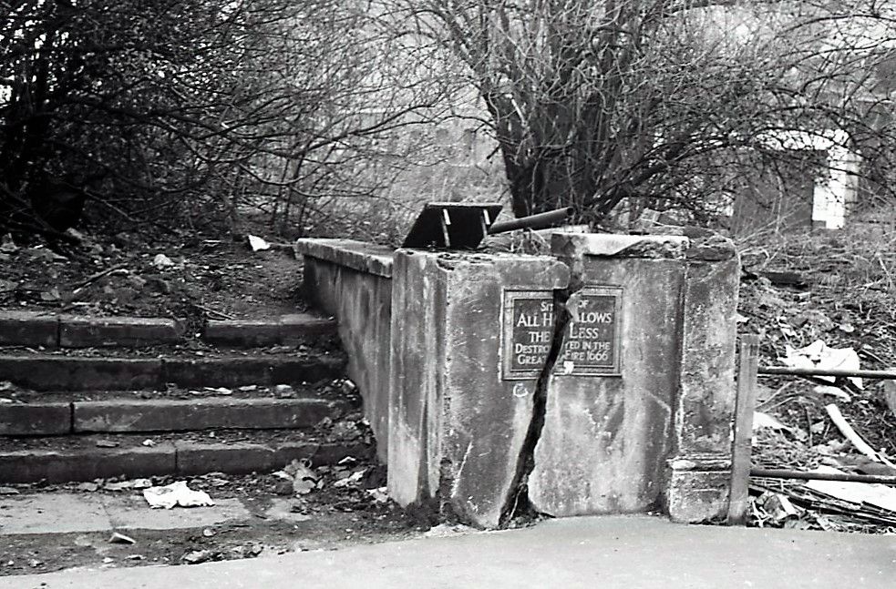
| Description | : | All-Hallows-the-Less was a church of medieval origin. It was destroyed in the Great Fire of London in 1666 and not rebuilt. Instead of rebuilding the church, the parish was united with that of All-Hallows-the-Great, and the site of the old All Hallows the Less was retained as a burial ground. (Very active in the late 17th Century and early 18th Century.) All-Hallows-the-Great itself was demolished in 1894, and the united parishes were in turn joined with that of St Michael Paternoster Royal under the Union of Benefices Act 1860. In 1896 some remains were disinterred from the churchyard and reburied... Read More |
frequently asked questions (FAQ):
-
Where is All Hallows the Less?
All Hallows the Less is located at London, City of London ,Greater London ,England.
-
All Hallows the Less cemetery's updated grave count on graveviews.com?
16 memorials
-
Where are the coordinates of the All Hallows the Less?
Latitude: 51.5099000
Longitude: -0.0893000
Nearby Cemetories:
1. All Hallows the Great
London, City of London, England
Coordinate: 51.5099720, -0.0900440
2. St Laurence Pountney Churchyard
London, City of London, England
Coordinate: 51.5106100, -0.0885930
3. St Martin Orgar Church
London, City of London, England
Coordinate: 51.5107520, -0.0875220
4. St Michael Bassishaw Crooked Lane
London, City of London, England
Coordinate: 51.5107000, -0.0872800
5. Saint Mary Bothaw (Defunct)
London, City of London, England
Coordinate: 51.5114000, -0.0900800
6. Saint Swithin London Stone Churchyard
London, City of London, England
Coordinate: 51.5115800, -0.0894340
7. St Mary Magdalene (Defunct)
London, City of London, England
Coordinate: 51.5100480, -0.0862540
8. St. Magnus the Martyr Churchyard
London, City of London, England
Coordinate: 51.5092500, -0.0862880
9. Great Fire of London Monument
London, City of London, England
Coordinate: 51.5101100, -0.0859990
10. St Clement's Eastcheap
London, City of London, England
Coordinate: 51.5114010, -0.0867810
11. St. Leonard's Churchyard
Bridge, City of London, England
Coordinate: 51.5105870, -0.0855570
12. St. George's Botolph Lane
Billingsgate, City of London, England
Coordinate: 51.5101840, -0.0847730
13. St Botolph Billingsgate Churchyard (Defunct)
London, City of London, England
Coordinate: 51.5096860, -0.0847310
14. St Mary Woolnoth Churchyard
London, City of London, England
Coordinate: 51.5127650, -0.0881070
15. St James Garlickhythe Churchyard
London, City of London, England
Coordinate: 51.5111070, -0.0937560
16. St Antholin's Church
London, City of London, England
Coordinate: 51.5126895, -0.0915805
17. St. Benet's Churchyard
Bridge, City of London, England
Coordinate: 51.5115240, -0.0846030
18. All Hallows Lombard Street
London, City of London, England
Coordinate: 51.5123000, -0.0854000
19. St. Mary-at-Hill Churchyard
Billingsgate, City of London, England
Coordinate: 51.5101050, -0.0836680
20. St. Benet Sherehog Churchyard (Defunct)
London, City of London, England
Coordinate: 51.5132700, -0.0912020
21. Saint Pancras Soper Lane (Defunct)
London, City of London, England
Coordinate: 51.5132830, -0.0918850
22. Southwark Cathedral
Southwark, London Borough of Southwark, England
Coordinate: 51.5061417, -0.0895970
23. Holy Trinity the Less Churchyard (Defunct)
London, City of London, England
Coordinate: 51.5119670, -0.0944820
24. St Mary Aldermary
London, City of London, England
Coordinate: 51.5127900, -0.0933800