
| Memorials | : | 79 |
| Location | : | London, City of London, England |
| Coordinate | : | 51.5126895, -0.0915805 |
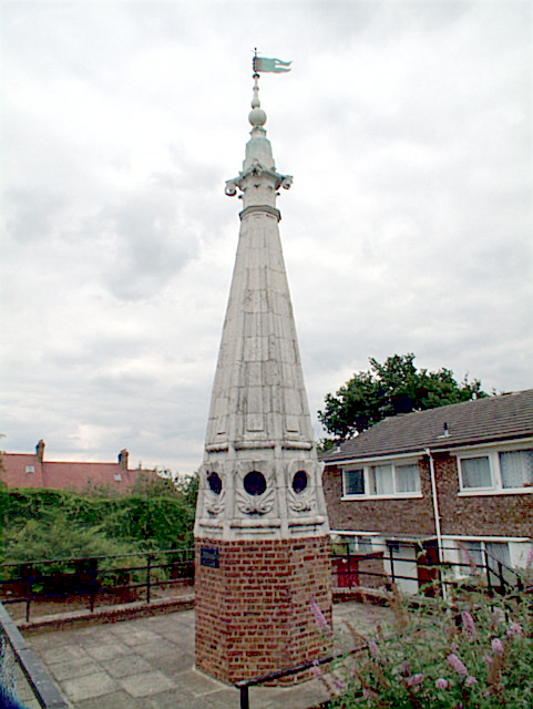
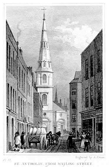
| Description | : | St Antholin, Budge Row, or St Antholin, Watling Street, was a church, first recorded in 1119, in the City of London. After its destruction in the Great Fire of London of 1666, it was rebuilt to the designs of Sir Christopher Wren at a cost of £5,685, paid for from the coal tax, and from contributions. The church was on the north side of Budge Row (which no longer exists), at the corner of Sise Lane in Cordwainer Ward. It was originally known as St Anthony's, or St Anthonine's It was dedicated to St Anthony the Great. ... Read More |
frequently asked questions (FAQ):
-
Where is St Antholin's Church?
St Antholin's Church is located at London, City of London ,Greater London ,England.
-
St Antholin's Church cemetery's updated grave count on graveviews.com?
79 memorials
-
Where are the coordinates of the St Antholin's Church?
Latitude: 51.5126895
Longitude: -0.0915805
Nearby Cemetories:
1. Saint Pancras Soper Lane (Defunct)
London, City of London, England
Coordinate: 51.5132830, -0.0918850
2. St. Benet Sherehog Churchyard (Defunct)
London, City of London, England
Coordinate: 51.5132700, -0.0912020
3. St Mary Colechurch (Defunct)
London, City of London, England
Coordinate: 51.5136110, -0.0911110
4. St Mary Aldermary
London, City of London, England
Coordinate: 51.5127900, -0.0933800
5. Church of Saint Mary Magdalen Milk Street
London, City of London, England
Coordinate: 51.5136110, -0.0930560
6. Mercers Chapel
London, City of London, England
Coordinate: 51.5141490, -0.0919390
7. Saint Mary Bothaw (Defunct)
London, City of London, England
Coordinate: 51.5114000, -0.0900800
8. St Mary-le-Bow
London, City of London, England
Coordinate: 51.5137100, -0.0935517
9. Saint Swithin London Stone Churchyard
London, City of London, England
Coordinate: 51.5115800, -0.0894340
10. St. Martin Pomary Churchyard
Cheap, City of London, England
Coordinate: 51.5145830, -0.0918610
11. All Hallows Churchyard
City of London, England
Coordinate: 51.5143760, -0.0930270
12. Holy Trinity the Less Churchyard (Defunct)
London, City of London, England
Coordinate: 51.5119670, -0.0944820
13. All Hallows Churchyard
London, City of London, England
Coordinate: 51.5131130, -0.0948140
14. St James Garlickhythe Churchyard
London, City of London, England
Coordinate: 51.5111070, -0.0937560
15. St Mary Woolnoth Churchyard
London, City of London, England
Coordinate: 51.5127650, -0.0881070
16. St Mildred Bread Street Church Demolished
London, City of London, England
Coordinate: 51.5123790, -0.0950740
17. St Christopher le Stocks
London, City of London, England
Coordinate: 51.5142000, -0.0886000
18. St. John the Evangelist Churchyard
Bread Street, City of London, England
Coordinate: 51.5124910, -0.0954840
19. St. Lawrence Jewry Churchyard
London, City of London, England
Coordinate: 51.5152340, -0.0924910
20. St Laurence Pountney Churchyard
London, City of London, England
Coordinate: 51.5106100, -0.0885930
21. All Hallows the Great
London, City of London, England
Coordinate: 51.5099720, -0.0900440
22. All Hallows the Less
London, City of London, England
Coordinate: 51.5099000, -0.0893000
23. Guildhall
London, City of London, England
Coordinate: 51.5158200, -0.0911380
24. St Martin Orgar Church
London, City of London, England
Coordinate: 51.5107520, -0.0875220