
| Memorials | : | 2 |
| Location | : | Cringleford, South Norfolk District, England |
| Website | : | www.roundtowerchurches.net/norfolk/norfolk-h-l/intwood-2/ |
| Coordinate | : | 52.5910430, 1.2419930 |
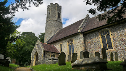
| Description | : | All Saints church is located in Intwood, a Norfolk village just to the south-east of the A47 Norwich Southern Bypass road, and only a few hundred yards from Keswick All Saints, another Round Tower Church. |
frequently asked questions (FAQ):
-
Where is All Saints Church, Intwood?
All Saints Church, Intwood is located at Cringleford, South Norfolk District ,Norfolk ,England.
-
All Saints Church, Intwood cemetery's updated grave count on graveviews.com?
2 memorials
-
Where are the coordinates of the All Saints Church, Intwood?
Latitude: 52.5910430
Longitude: 1.2419930
Nearby Cemetories:
1. Keswick Churchyard
Keswick, South Norfolk District, England
Coordinate: 52.5909460, 1.2419310
2. St. Peter's Churchyard
Cringleford, South Norfolk District, England
Coordinate: 52.6057990, 1.2453370
3. All Saints Churchyard
Keswick, South Norfolk District, England
Coordinate: 52.5951470, 1.2675790
4. Eaton Parish Burial Ground
Eaton, City of Norwich, England
Coordinate: 52.6053900, 1.2556800
5. St. Andrew's Old Churchyard
Eaton, City of Norwich, England
Coordinate: 52.6068200, 1.2514300
6. St Mary Churchyard
East Carleton, South Norfolk District, England
Coordinate: 52.5726700, 1.2153470
7. St. Mary Magdalen Churchyard
Mulbarton, South Norfolk District, England
Coordinate: 52.5638930, 1.2360530
8. Saint Edmund Churchyard
Caistor St Edmund, South Norfolk District, England
Coordinate: 52.5826350, 1.2936850
9. St. Peter's Churchyard
Ketteringham, South Norfolk District, England
Coordinate: 52.5778000, 1.1921000
10. Saint Remigius Churchyard
Hethersett, South Norfolk District, England
Coordinate: 52.5992830, 1.1889340
11. St Remigius Churchyard
Dunston, South Norfolk District, England
Coordinate: 52.5722420, 1.2872510
12. St. Andrew Churchyard
Colney, South Norfolk District, England
Coordinate: 52.6253800, 1.2206100
13. St. John the Baptist Churchyard
Lakenham, City of Norwich, England
Coordinate: 52.6068660, 1.2971750
14. St. Mary's Churchyard
Earlham, City of Norwich, England
Coordinate: 52.6280416, 1.2353034
15. St Nicholas Churchyard
Bracon Ash, South Norfolk District, England
Coordinate: 52.5559000, 1.2137000
16. All Saints Churchyard
Hethel, South Norfolk District, England
Coordinate: 52.5578530, 1.2014560
17. Earlham Road Cemetery
Norwich, City of Norwich, England
Coordinate: 52.6305900, 1.2677400
18. Colney Woodland Burial Park
Colney, South Norfolk District, England
Coordinate: 52.6254580, 1.1991560
19. Saint Mark's Churchyard
Lakenham, City of Norwich, England
Coordinate: 52.6189230, 1.2986720
20. Cathedral of Saint John the Baptist
Norwich, City of Norwich, England
Coordinate: 52.6292000, 1.2840000
21. St Mary's and All Saints Churchyard
Little Melton, South Norfolk District, England
Coordinate: 52.6173083, 1.1798046
22. St. John Sepulchre Churchyard
Norwich, City of Norwich, England
Coordinate: 52.6215710, 1.2999370
23. Saint Stephens Churchyard
Norwich, City of Norwich, England
Coordinate: 52.6266260, 1.2921140
24. St Giles Churchyard
Norwich, City of Norwich, England
Coordinate: 52.6294900, 1.2871500