
| Memorials | : | 0 |
| Location | : | Epping Upland, Epping Forest District, England |
| Coordinate | : | 51.7207440, 0.0888980 |
| Description | : | Epping is a small market town and civil parish in the Epping Forest district of the County of Essex, England. It is located 17 miles north-east of the centre of London towards the northern end of Epping Forest on a ridge of land between the River Roding and River Lea valleys, 3.5 miles north-east of Loughton, 4.6 miles south of Harlow and 10.9 miles north-west of Brentwood. It is north-east of junction 26 (Waltham Abbey, Loughton A121) of the M25 motorway and south-west of junction 7 (Harlow) of the M11 motorway. The town retains a rural appearance being surrounded by... Read More |
frequently asked questions (FAQ):
-
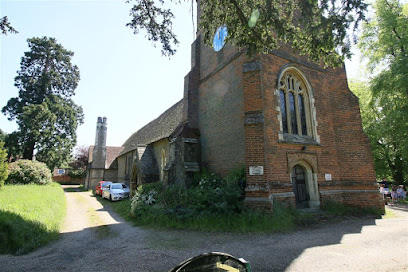
Where is All Saints Churchyard?
All Saints Churchyard is located at Epping Upland, Epping Forest District ,Essex ,England.
-
All Saints Churchyard cemetery's updated grave count on graveviews.com?
0 memorials
-
Where are the coordinates of the All Saints Churchyard?
Latitude: 51.7207440
Longitude: 0.0888980
Nearby Cemetories:
1. Parndon Wood Crematorium and Cemetery
Harlow, Harlow District, England
Coordinate: 51.7430160, 0.0898420
2. Epping Cemetery
Epping, Epping Forest District, England
Coordinate: 51.6978250, 0.0974260
3. St Alban the Martyr Churchyard
Coopersale, Epping Forest District, England
Coordinate: 51.7020000, 0.1338200
4. All Saints Churchyard
Nazeing, Epping Forest District, England
Coordinate: 51.7436140, 0.0464100
5. St. Thomas Churchyard
Upshire, Epping Forest District, England
Coordinate: 51.6898890, 0.0465860
6. St Mary the Virgin Churchyard
Great Parndon, Harlow District, England
Coordinate: 51.7605100, 0.0739860
7. St. Mary Magdalene Churchyard
Potter Street, Harlow District, England
Coordinate: 51.7558200, 0.1315900
8. St Andrew Churchyard
Netteswell, Harlow District, England
Coordinate: 51.7640460, 0.1085500
9. Potter Street Baptist Churchyard
Harlow, Harlow District, England
Coordinate: 51.7575040, 0.1326510
10. North Weald Bassett Cemetery
North Weald Bassett, Epping Forest District, England
Coordinate: 51.7254250, 0.1622850
11. St. Andrew's Churchyard
North Weald Bassett, Epping Forest District, England
Coordinate: 51.7254630, 0.1638090
12. St. Mary the Virgin Churchyard
Theydon Bois, Epping Forest District, England
Coordinate: 51.6736030, 0.0931960
13. All Saints Churchyard
Theydon Garnon, Epping Forest District, England
Coordinate: 51.6738900, 0.1272110
14. Waltham Abbey Jewish Cemetery
Waltham Abbey, Epping Forest District, England
Coordinate: 51.6778780, 0.0389240
15. Roydon United Reform Churchyard
Roydon, Epping Forest District, England
Coordinate: 51.7714050, 0.0460240
16. Theydon Bois Cemetery
Theydon Bois, Epping Forest District, England
Coordinate: 51.6651420, 0.1117300
17. St. Mary's Churchyard
Little Parndon, Harlow District, England
Coordinate: 51.7792683, 0.0840760
18. Harlow Baptist Burial Ground
Harlow, Harlow District, England
Coordinate: 51.7619700, 0.1584330
19. St Mary-at-Latton Churchyard
Latton, Harlow District, England
Coordinate: 51.7774500, 0.1206750
20. St Michael Churchyard
Theydon Mount, Epping Forest District, England
Coordinate: 51.6721100, 0.1574700
21. St Botolph Church
Eastwick, East Hertfordshire District, England
Coordinate: 51.7851000, 0.0776000
22. Waltham Holy Cross Old Cemetery
Waltham Abbey, Epping Forest District, England
Coordinate: 51.6823480, 0.0027610
23. Waltham Holy Cross-New Cemetery
Waltham Abbey, Epping Forest District, England
Coordinate: 51.6822880, 0.0024510
24. Waltham Abbey
Waltham Abbey, Epping Forest District, England
Coordinate: 51.6876010, -0.0034070