
| Memorials | : | 3 |
| Location | : | Eastwick, East Hertfordshire District, England |
| Coordinate | : | 51.7851000, 0.0776000 |
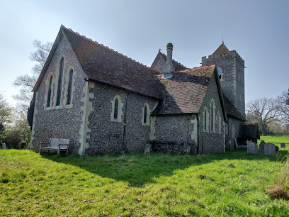
| Description | : | The church of St Botolph is a ancient church, partly in the Norman style of architecture: it has a porch, aisles, transept, chancel, and square embattled tower containing 3 bells. It was rebuilt in 1872-3 by A W Blomfield incorporating the old tower and 13th century chancel arch. The opening to the Organ chamber is a 13th century recumbent, marble effigy of a knight with crossed legs, on a moulded base under tower, Richard de Tany died 1270, the best 13th century effigy in the county. Above this a fine wall monument with 3 Corinthian columns to Mary Plummer died 1700. Opposite a wall... Read More |
frequently asked questions (FAQ):
-
Where is St Botolph Church?
St Botolph Church is located at Eastwick Hall Lane Eastwick, East Hertfordshire District ,Hertfordshire , CM20 2QYEngland.
-
St Botolph Church cemetery's updated grave count on graveviews.com?
0 memorials
-
Where are the coordinates of the St Botolph Church?
Latitude: 51.7851000
Longitude: 0.0776000
Nearby Cemetories:
1. St. Mary's Churchyard
Little Parndon, Harlow District, England
Coordinate: 51.7792683, 0.0840760
2. St Mary's Churchyard
Gilston, East Hertfordshire District, England
Coordinate: 51.8016340, 0.0855550
3. St. Dunstan Churchyard
Hunsdon, East Hertfordshire District, England
Coordinate: 51.7951000, 0.0548190
4. Roydon United Reform Churchyard
Roydon, Epping Forest District, England
Coordinate: 51.7714050, 0.0460240
5. St Mary the Virgin Churchyard
Great Parndon, Harlow District, England
Coordinate: 51.7605100, 0.0739860
6. St Mary-at-Latton Churchyard
Latton, Harlow District, England
Coordinate: 51.7774500, 0.1206750
7. St Andrew Churchyard
Netteswell, Harlow District, England
Coordinate: 51.7640460, 0.1085500
8. St James' Churchyard
Stanstead Abbotts, East Hertfordshire District, England
Coordinate: 51.7806920, 0.0275950
9. Saint James the Great Churchyard
Sawbridgeworth, East Hertfordshire District, England
Coordinate: 51.8066600, 0.1213100
10. St. John the Baptist Churchyard
Widford, East Hertfordshire District, England
Coordinate: 51.8228370, 0.0491000
11. Parndon Wood Crematorium and Cemetery
Harlow, Harlow District, England
Coordinate: 51.7430160, 0.0898420
12. Potter Street Baptist Churchyard
Harlow, Harlow District, England
Coordinate: 51.7575040, 0.1326510
13. St Mary and St Hugh Churchyard
Old Harlow, Harlow District, England
Coordinate: 51.7822500, 0.1486600
14. St. Mary Magdalene Churchyard
Potter Street, Harlow District, England
Coordinate: 51.7558200, 0.1315900
15. All Saints Churchyard
Nazeing, Epping Forest District, England
Coordinate: 51.7436140, 0.0464100
16. St. Margaret's Parish Churchyard
Stanstead St Margarets, East Hertfordshire District, England
Coordinate: 51.7857570, -0.0002631
17. Holy Trinity Churchyard
Wareside, East Hertfordshire District, England
Coordinate: 51.8212430, 0.0221440
18. Great St. Mary Churchyard
Sawbridgeworth, East Hertfordshire District, England
Coordinate: 51.8123290, 0.1527570
19. Harlow Baptist Burial Ground
Harlow, Harlow District, England
Coordinate: 51.7619700, 0.1584330
20. St John the Baptist Churchyard
Great Amwell, East Hertfordshire District, England
Coordinate: 51.7944320, -0.0123740
21. St. Thomas' Churchyard
Perry Green, East Hertfordshire District, England
Coordinate: 51.8419070, 0.0835140
22. Hoddesdon Cemetery
Hoddesdon, Broxbourne Borough, England
Coordinate: 51.7711490, -0.0156822
23. St Catherine and St Paul's Churchyard
Hoddesdon, Broxbourne Borough, England
Coordinate: 51.7625830, -0.0120670
24. Quaker Burial Ground, Hoddesdon, Hertfordshire
Hoddesdon, Broxbourne Borough, England
Coordinate: 51.7610213, -0.0139560