
| Memorials | : | 0 |
| Location | : | All Cannings, Wiltshire Unitary Authority, England |
| Coordinate | : | 51.3531290, -1.9013160 |
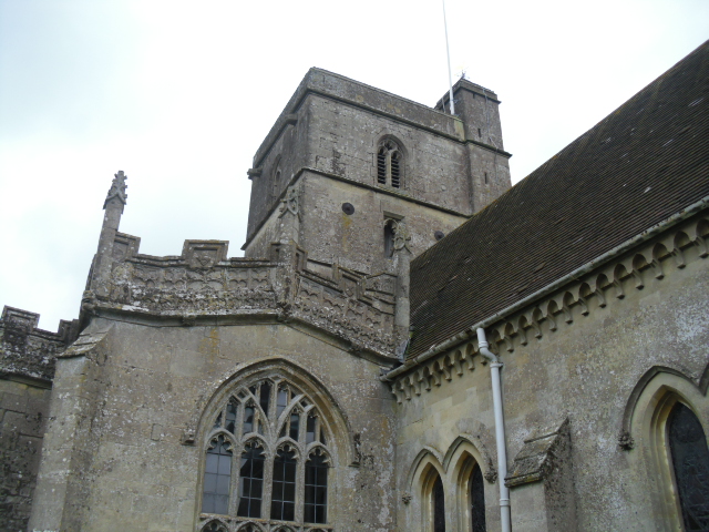
| Description | : | The church dates from the 13th century and is now cruciform in shape with an aisled nave of three bays, a central tower, north and south transepts, a south chapel, north and south porches, and a 19th century chancel. Late Norman features remaining include part of the chancel arch; it is thought that the Norman church probably had only one aisle. 14th century features include the piers of the crossing supporting the tower and the outer arch of the north porch. The cruciform pattern probably dates from this time.The three stage Perpendicular tower itself dates from the mid 15th century... Read More |
frequently asked questions (FAQ):
-
Where is All Saints Churchyard?
All Saints Churchyard is located at The St All Cannings, Wiltshire Unitary Authority ,Wiltshire , SN10 3NREngland.
-
All Saints Churchyard cemetery's updated grave count on graveviews.com?
0 memorials
-
Where are the coordinates of the All Saints Churchyard?
Latitude: 51.3531290
Longitude: -1.9013160
Nearby Cemetories:
1. All Saints Churchyard
All Cannings, Wiltshire Unitary Authority, England
Coordinate: 51.3532600, -1.9014490
2. St Stephens - Beechingstoke
Beechingstoke, Wiltshire Unitary Authority, England
Coordinate: 51.3322290, -1.8782996
3. Church of St. Mary
Alton Barnes, Wiltshire Unitary Authority, England
Coordinate: 51.3572180, -1.8467440
4. St John the Baptist Churchyard
Chirton, Wiltshire Unitary Authority, England
Coordinate: 51.3176500, -1.8958100
5. All Saints Churchyard
Alton Priors, Wiltshire Unitary Authority, England
Coordinate: 51.3580240, -1.8447630
6. St Mary the Virgin Churchyard
Bishops Cannings, Wiltshire Unitary Authority, England
Coordinate: 51.3766560, -1.9471530
7. Adam’s Grave
Alton Barnes, Wiltshire Unitary Authority, England
Coordinate: 51.3694910, -1.8399100
8. Saint Mary the Virgin Churchyard
Devizes, Wiltshire Unitary Authority, England
Coordinate: 51.3534370, -1.9930310
9. Roundway Asylum Cemetery
Devizes, Wiltshire Unitary Authority, England
Coordinate: 51.3370470, -1.9900090
10. St. John The Baptist Churchyard
Devizes, Wiltshire Unitary Authority, England
Coordinate: 51.3502300, -1.9947490
11. Friends Burial Ground
Devizes, Wiltshire Unitary Authority, England
Coordinate: 51.3474356, -1.9945100
12. Christ Church
East Kennett, Wiltshire Unitary Authority, England
Coordinate: 51.4058760, -1.8328740
13. Saint James Churchyard
Avebury, Wiltshire Unitary Authority, England
Coordinate: 51.4280700, -1.8575100
14. Avebury Chapel
Avebury, Wiltshire Unitary Authority, England
Coordinate: 51.4284210, -1.8562170
15. St Swithin Churchyard
Compton Bassett, Wiltshire Unitary Authority, England
Coordinate: 51.4433640, -1.9569990
16. Calne Holy Trinity Churchyard
Calne Without, Wiltshire Unitary Authority, England
Coordinate: 51.4303550, -1.9975930
17. Bromham Cemetery
Bromham, Wiltshire Unitary Authority, England
Coordinate: 51.3854000, -2.0538000
18. St. Nicholas' Churchyard
Bromham, Wiltshire Unitary Authority, England
Coordinate: 51.3857110, -2.0543780
19. St Mary the Virgin Churchyard
Calne, Wiltshire Unitary Authority, England
Coordinate: 51.4371650, -2.0027540
20. Chittoe Graveyard
Chippenham, Wiltshire Unitary Authority, England
Coordinate: 51.3985740, -2.0637040
21. Curzon Street Cemetery
Calne, Wiltshire Unitary Authority, England
Coordinate: 51.4409010, -2.0107130
22. Christ Church
Bulkington, Wiltshire Unitary Authority, England
Coordinate: 51.3244800, -2.0869130
23. Christ Church
Derry Hill, Wiltshire Unitary Authority, England
Coordinate: 51.4368890, -2.0654300
24. Cadley Churchyard
Cadley, Wiltshire Unitary Authority, England
Coordinate: 51.3977930, -1.7013010