
| Memorials | : | 0 |
| Location | : | Florence, Boone County, USA |
| Coordinate | : | 39.0200560, -84.6594120 |
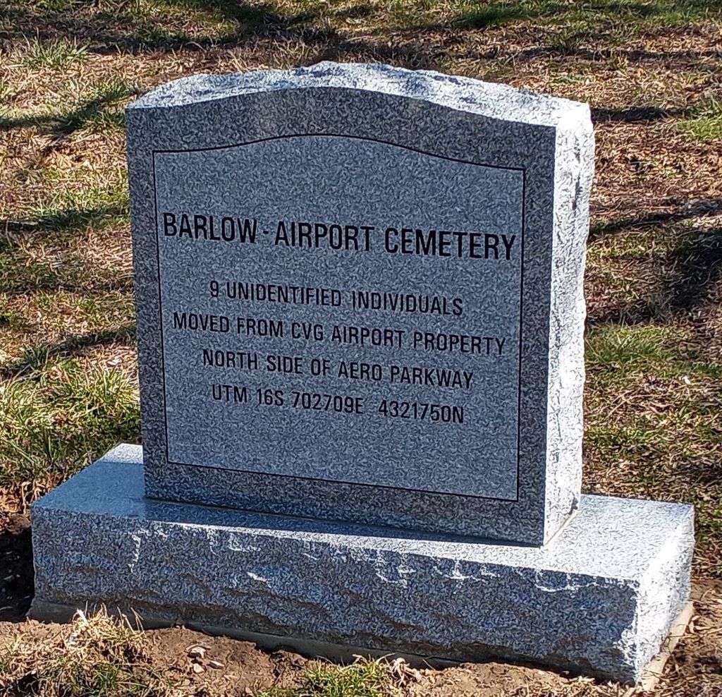
| Description | : | The cemetery was located on the north side of Aero Parkway about 0.5 mile west of its intersection with Ted Bushelman Boulevard. The cemetery was moved in its entirety to the Hebron Lutheran Church Cemetery in 2020. The Boone County GIS unique ID assigned to this cemetery is 14 (Barlow – Airport Cemetery). The cemetery has an index number of 14 (Barlow - Airport) on the Boone County Kentucky Cemetery Map published in 2005 by the Boone County Planning Commission in conjunction with Johnson-Wilson Cemetery Stewards Association. The cemetery is identified as the Barlow-Airport Cemetery in the Boone... Read More |
frequently asked questions (FAQ):
-
Where is Barlow–Airport Cemetery (Defunct)?
Barlow–Airport Cemetery (Defunct) is located at Aero Parkway (Kentucky State Highway 1017) Florence, Boone County ,Kentucky , 41042USA.
-
Barlow–Airport Cemetery (Defunct) cemetery's updated grave count on graveviews.com?
0 memorials
-
Where are the coordinates of the Barlow–Airport Cemetery (Defunct)?
Latitude: 39.0200560
Longitude: -84.6594120
Nearby Cemetories:
1. Daniel Beemon Cemetery
Florence, Boone County, USA
Coordinate: 39.0141670, -84.6641670
2. Vaughan-Marquis Cemetery
Florence, Boone County, USA
Coordinate: 39.0120470, -84.6527480
3. Popham Cemetery #02 (Defunct)
Limaburg, Boone County, USA
Coordinate: 39.0309770, -84.6647720
4. Milton Beemon Cemetery
Florence, Boone County, USA
Coordinate: 39.0111110, -84.6700000
5. Ann Popham Cemetery
Limaburg, Boone County, USA
Coordinate: 39.0333330, -84.6633330
6. William Aylor Cemetery (Defunct)
Florence, Boone County, USA
Coordinate: 39.0203480, -84.6778680
7. Weaver Cemetery
Florence, Boone County, USA
Coordinate: 39.0283012, -84.6755981
8. Limaburg Cemetery
Limaburg, Boone County, USA
Coordinate: 39.0303260, -84.6741860
9. Aylor Cemetery (Defunct)
Florence, Boone County, USA
Coordinate: 39.0169973, -84.6793854
10. Joshua Zimmerman Cemetery
Florence, Boone County, USA
Coordinate: 39.0074220, -84.6462590
11. Brown Cemetery
Hebron, Boone County, USA
Coordinate: 39.0377780, -84.6613890
12. Christy Family Cemetery
Burlington, Boone County, USA
Coordinate: 39.0380790, -84.6617180
13. Garnet Cemetery
Florence, Boone County, USA
Coordinate: 39.0377998, -84.6694031
14. Hopeful Lutheran Church Cemetery
Florence, Boone County, USA
Coordinate: 39.0005302, -84.6577225
15. Ashbrook-Cheek Cemetery (Defunct)
Florence, Boone County, USA
Coordinate: 39.0116670, -84.6308350
16. E Rouse Cemetery (Defunct)
Hebron, Boone County, USA
Coordinate: 39.0316670, -84.6869440
17. Clore-Connor Cemetery
Oakbrook, Boone County, USA
Coordinate: 38.9979750, -84.6758810
18. Saint Pius X Seminary Cemetery
Florence, Boone County, USA
Coordinate: 39.0289460, -84.6280990
19. Passionist Monastery Cemetery
Erlanger, Kenton County, USA
Coordinate: 39.0350600, -84.6305300
20. Clutterbuck Cemetery
Florence, Boone County, USA
Coordinate: 39.0041670, -84.6297230
21. Florence Cemetery
Florence, Boone County, USA
Coordinate: 39.0001000, -84.6309800
22. Snyder-Blankenbecker Cemetery
Florence, Boone County, USA
Coordinate: 38.9855560, -84.6458330
23. Barlow Family Cemetery
Florence, Boone County, USA
Coordinate: 38.9881990, -84.6827190
24. Carpenter Family Cemetery
Florence, Boone County, USA
Coordinate: 38.9914700, -84.6298610