
| Memorials | : | 0 |
| Location | : | Limaburg, Boone County, USA |
| Coordinate | : | 39.0309770, -84.6647720 |
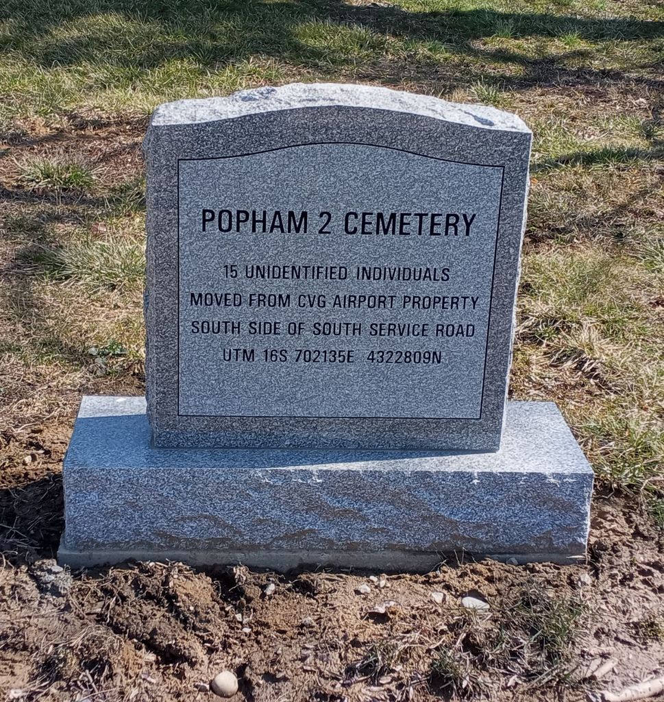
| Description | : | The cemetery was located on the property of the Northern Kentucky Greater Cincinnati Airport on the edge of Scudder Field on the south side of the South Service Road about 0.5 miles west of its intersection with Wendell H Ford Boulevard. The cemetery was moved in its entirety to the Hebron Lutheran Church Cemetery in 2020. The Boone County GIS unique ID assigned to this cemetery is 129 (Popham 2 Cemetery). The cemetery has an index number of 131 (Popham 2 Cemetery) on the Boone County Kentucky Cemetery Map published in 2005 by the Boone County Planning Commission... Read More |
frequently asked questions (FAQ):
-
Where is Popham Cemetery #02 (Defunct)?
Popham Cemetery #02 (Defunct) is located at South Service Road Limaburg, Boone County ,Kentucky , 41048USA.
-
Popham Cemetery #02 (Defunct) cemetery's updated grave count on graveviews.com?
0 memorials
-
Where are the coordinates of the Popham Cemetery #02 (Defunct)?
Latitude: 39.0309770
Longitude: -84.6647720
Nearby Cemetories:
1. Ann Popham Cemetery
Limaburg, Boone County, USA
Coordinate: 39.0333330, -84.6633330
2. Brown Cemetery
Hebron, Boone County, USA
Coordinate: 39.0377780, -84.6613890
3. Limaburg Cemetery
Limaburg, Boone County, USA
Coordinate: 39.0303260, -84.6741860
4. Christy Family Cemetery
Burlington, Boone County, USA
Coordinate: 39.0380790, -84.6617180
5. Garnet Cemetery
Florence, Boone County, USA
Coordinate: 39.0377998, -84.6694031
6. Weaver Cemetery
Florence, Boone County, USA
Coordinate: 39.0283012, -84.6755981
7. Barlow–Airport Cemetery (Defunct)
Florence, Boone County, USA
Coordinate: 39.0200560, -84.6594120
8. William Aylor Cemetery (Defunct)
Florence, Boone County, USA
Coordinate: 39.0203480, -84.6778680
9. Daniel Beemon Cemetery
Florence, Boone County, USA
Coordinate: 39.0141670, -84.6641670
10. E Rouse Cemetery (Defunct)
Hebron, Boone County, USA
Coordinate: 39.0316670, -84.6869440
11. Aylor Cemetery (Defunct)
Florence, Boone County, USA
Coordinate: 39.0169973, -84.6793854
12. Milton Beemon Cemetery
Florence, Boone County, USA
Coordinate: 39.0111110, -84.6700000
13. Vaughan-Marquis Cemetery
Florence, Boone County, USA
Coordinate: 39.0120470, -84.6527480
14. Passionist Monastery Cemetery
Erlanger, Kenton County, USA
Coordinate: 39.0350600, -84.6305300
15. Joshua Zimmerman Cemetery
Florence, Boone County, USA
Coordinate: 39.0074220, -84.6462590
16. Saint Pius X Seminary Cemetery
Florence, Boone County, USA
Coordinate: 39.0289460, -84.6280990
17. Hopeful Lutheran Church Cemetery
Florence, Boone County, USA
Coordinate: 39.0005302, -84.6577225
18. Ashbrook-Cheek Cemetery (Defunct)
Florence, Boone County, USA
Coordinate: 39.0116670, -84.6308350
19. McNeal Family Cemetery
Florence, Boone County, USA
Coordinate: 39.0638790, -84.6581350
20. Brown Family Cemetery
Florence, Boone County, USA
Coordinate: 39.0548528, -84.6346639
21. Clore-Connor Cemetery
Oakbrook, Boone County, USA
Coordinate: 38.9979750, -84.6758810
22. Rouse-Utz Cemetery
Burlington, Boone County, USA
Coordinate: 39.0372220, -84.7127780
23. Walton Cemetery
Hebron, Boone County, USA
Coordinate: 39.0456700, -84.6198900
24. Clutterbuck Cemetery
Florence, Boone County, USA
Coordinate: 39.0041670, -84.6297230