
| Memorials | : | 0 |
| Location | : | Rutherford, Russell County, USA |
| Coordinate | : | 32.1723300, -85.3044800 |
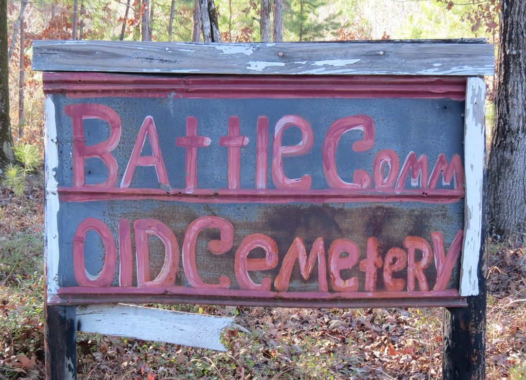
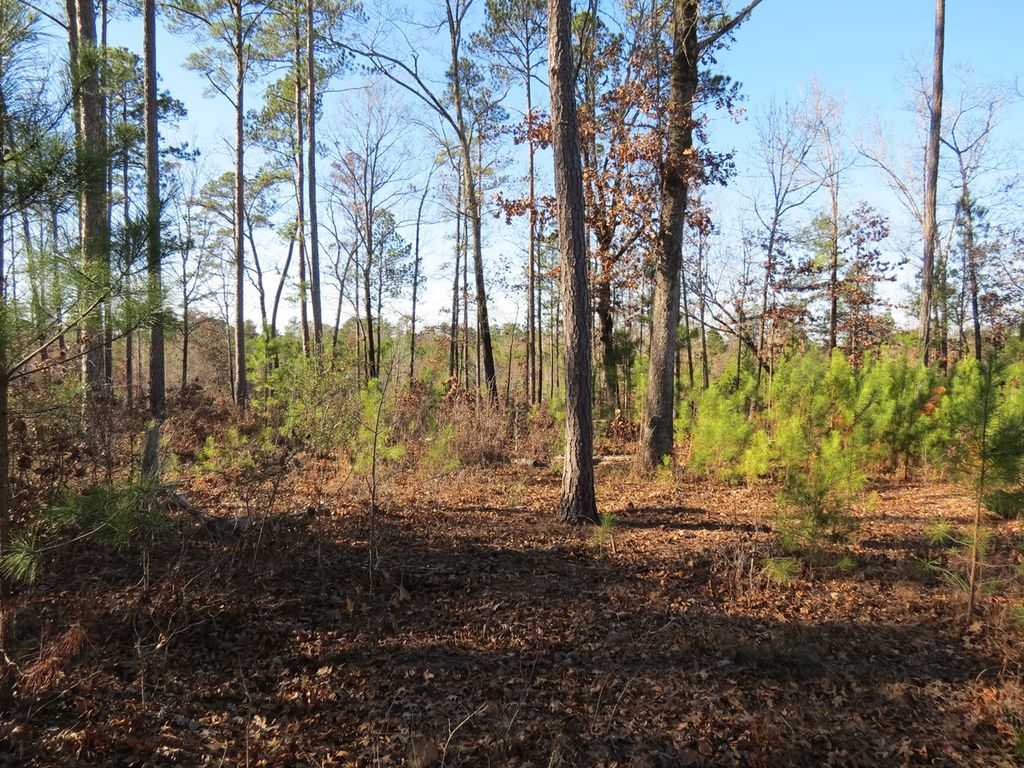
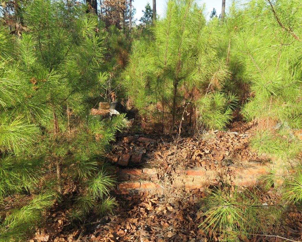
| Description | : | "Old Battle Community Cemetery" The cemetery is located about 400 yards down a dirt logging trail off the east side of Rutherford Road, 1.8 miles north of the Russell-Barbour county line. Map placement is exact. The entrance is marked by a large white sign on Rutherford Road, but the trail must be crossed on foot or via a 4x4 vehicle. There is heavy undergrowth and young pines provide dense cover for the southern third of the cemetery. Many grave depressions (potentially hundreds) are visible but few burials are marked. |
frequently asked questions (FAQ):
-
Where is Battle Cemetery?
Battle Cemetery is located at Rutherford Road Rutherford, Russell County ,Alabama ,USA.
-
Battle Cemetery cemetery's updated grave count on graveviews.com?
0 memorials
-
Where are the coordinates of the Battle Cemetery?
Latitude: 32.1723300
Longitude: -85.3044800
Nearby Cemetories:
1. Shady Grove Baptist Church Cemetery
Rutherford, Russell County, USA
Coordinate: 32.1561950, -85.3079400
2. Mount Missouri Baptist Church Cemetery
Rutherford, Russell County, USA
Coordinate: 32.1938210, -85.3149720
3. Antioch Missionary Baptist Church Cemetery
Pittsview, Russell County, USA
Coordinate: 32.1937180, -85.2585410
4. Zion Hill Baptist Church Cemetery
Hatchechubbee, Russell County, USA
Coordinate: 32.2289200, -85.2851820
5. Hurts African Methodist Episcopal Chapel
Hurtsboro, Russell County, USA
Coordinate: 32.2110670, -85.3582230
6. Olivet Methodist Cemetery
Hurtsboro, Russell County, USA
Coordinate: 32.2121570, -85.3583410
7. Benevolent Grove Baptist Church Cemetery
Pittsview, Russell County, USA
Coordinate: 32.1954250, -85.2326310
8. Ebenezer Baptist Church Cemetery
Hurtsboro, Russell County, USA
Coordinate: 32.2026900, -85.3800100
9. Friendship Baptist Church Cemetery
Hurtsboro, Russell County, USA
Coordinate: 32.2428670, -85.3293680
10. Nero Baptist Church Cemetery
Spring Hill, Barbour County, USA
Coordinate: 32.1192210, -85.3854150
11. Humble Zion Baptist Church Cemetery
Spring Hill, Barbour County, USA
Coordinate: 32.0911780, -85.3524530
12. Spring Hill United Methodist Church Cemetery
Spring Hill, Barbour County, USA
Coordinate: 32.0801353, -85.3389969
13. Springhill Zion Baptist Church Cemetery
Eufaula, Barbour County, USA
Coordinate: 32.0746000, -85.3271600
14. Mount Gilead Cemetery
Barbour County, USA
Coordinate: 32.0891991, -85.2394028
15. Bethel Christian Fellowship Cemetery
Pittsview, Russell County, USA
Coordinate: 32.2054160, -85.1902530
16. Old Nero Baptist Church Cemetery
Hurtsboro, Russell County, USA
Coordinate: 32.2349380, -85.4009450
17. Hatchechubbee United Methodist Church Cemetery
Hatchechubbee, Russell County, USA
Coordinate: 32.2725440, -85.2738180
18. Ramah Baptist Church Cemetery
Barbour County, USA
Coordinate: 32.1058006, -85.3985977
19. Mount Mariah Baptist Church Cemetery
Pittsview, Russell County, USA
Coordinate: 32.2410180, -85.2094780
20. Brown Road Cemetery
Russell County, USA
Coordinate: 32.1897011, -85.4302979
21. Mount Sinai Baptist Church Cemetery
Hatchechubbee, Russell County, USA
Coordinate: 32.2808640, -85.2863270
22. Milligan Cemetery
Hatchechubbee, Russell County, USA
Coordinate: 32.1618500, -85.1713200
23. Mount Olive Missionary Baptist Church Cemetery
Comer, Barbour County, USA
Coordinate: 32.0734878, -85.3827183
24. Ross Chapel AME Zion Church Cemetery
Hurtsboro, Russell County, USA
Coordinate: 32.2396830, -85.4216130