
| Memorials | : | 0 |
| Location | : | Barbour County, USA |
| Coordinate | : | 32.1058006, -85.3985977 |
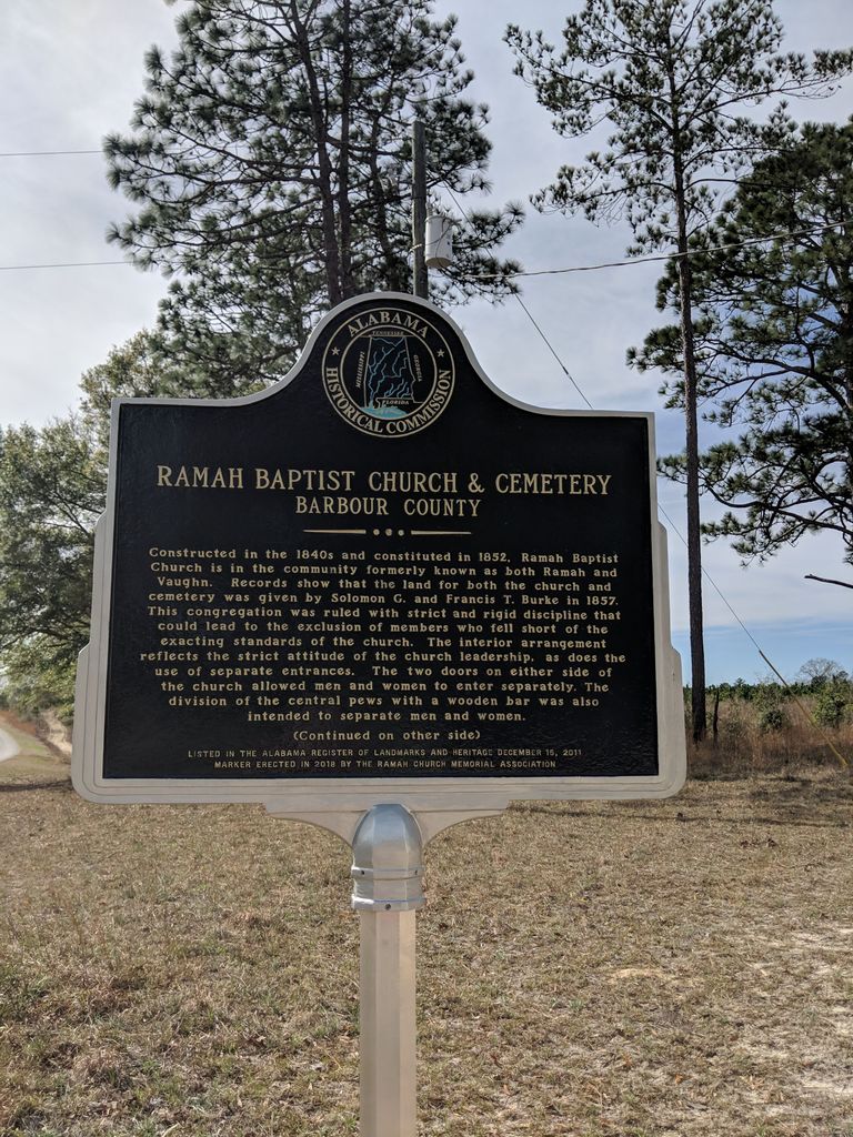
| Description | : | 19 December 2011: The Alabama Historical Commission (AHC) added the Ramah Baptist Church in Midway to the Alabama Register of Landmarks & Heritage. Ramah Baptist Church was listed in the Alabama Register for its religious and architectural significance. Built before 1843, it is an excellent example of a rural, one room church that retains a high degree of historic integrity. The Ramah Church Memorial Association was organized in 1963 for the purpose or preserving the church and cemetery and for creating a fund for their maintenance. (See: http://ramahchurch.com/index.htm |
frequently asked questions (FAQ):
-
Where is Ramah Baptist Church Cemetery?
Ramah Baptist Church Cemetery is located at 863 Bear Creek Road Barbour County ,Alabama ,USA.
-
Ramah Baptist Church Cemetery cemetery's updated grave count on graveviews.com?
0 memorials
-
Where are the coordinates of the Ramah Baptist Church Cemetery?
Latitude: 32.1058006
Longitude: -85.3985977


Nearby Cemetories:
1. Nero Baptist Church Cemetery
Spring Hill, Barbour County, USA
Coordinate: 32.1192210, -85.3854150
2. Mount Olive Missionary Baptist Church Cemetery
Comer, Barbour County, USA
Coordinate: 32.0734878, -85.3827183
3. Humble Zion Baptist Church Cemetery
Spring Hill, Barbour County, USA
Coordinate: 32.0911780, -85.3524530
4. Great Hope AME Church Cemetery
Midway, Bullock County, USA
Coordinate: 32.0956820, -85.4519860
5. Spring Hill United Methodist Church Cemetery
Spring Hill, Barbour County, USA
Coordinate: 32.0801353, -85.3389969
6. Springhill Zion Baptist Church Cemetery
Eufaula, Barbour County, USA
Coordinate: 32.0746000, -85.3271600
7. Seay Cemetery
Bullock County, USA
Coordinate: 32.0344009, -85.4578018
8. Mount Pleasant Hill Baptist Church Cemetery
Midway, Bullock County, USA
Coordinate: 32.0315300, -85.4541000
9. Brown Road Cemetery
Russell County, USA
Coordinate: 32.1897011, -85.4302979
10. Shady Grove Baptist Church Cemetery
Rutherford, Russell County, USA
Coordinate: 32.1561950, -85.3079400
11. Saint Luke A.M.E. Church Cemetery
Midway, Bullock County, USA
Coordinate: 32.1526340, -85.4921830
12. Ebenezer Baptist Church Cemetery
Hurtsboro, Russell County, USA
Coordinate: 32.2026900, -85.3800100
13. Enon Cemetery
Enon, Bullock County, USA
Coordinate: 32.1545982, -85.4991989
14. Fellowship Cemetery
Midway, Bullock County, USA
Coordinate: 32.1046982, -85.5160980
15. Battle Cemetery
Rutherford, Russell County, USA
Coordinate: 32.1723300, -85.3044800
16. Midway Baptist Cemetery
Midway, Bullock County, USA
Coordinate: 32.0804600, -85.5187800
17. Hurts African Methodist Episcopal Chapel
Hurtsboro, Russell County, USA
Coordinate: 32.2110670, -85.3582230
18. Hayes Hill Missionary Baptist Church Cemetery
Midway, Bullock County, USA
Coordinate: 32.1082190, -85.5302430
19. Olivet Methodist Cemetery
Hurtsboro, Russell County, USA
Coordinate: 32.2121570, -85.3583410
20. Mount Missouri Baptist Church Cemetery
Rutherford, Russell County, USA
Coordinate: 32.1938210, -85.3149720
21. Calvary Baptist Church Cemetery
Bullock County, USA
Coordinate: 32.2016046, -85.4727760
22. Provo Cemetery
Bullock County, USA
Coordinate: 32.2047005, -85.4744034
23. New Mount Silla Baptist Church Cemetery
Barbour County, USA
Coordinate: 31.9925270, -85.4488170
24. Old Batesville Church Cemetery
Barbour County, USA
Coordinate: 32.0078011, -85.3091965