
| Memorials | : | 19 |
| Location | : | Bottesford, Melton Borough, England |
| Coordinate | : | 52.8982090, -0.7825130 |
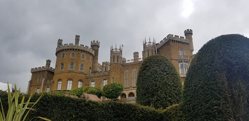
| Description | : | A Benedictine priory dedicated to St. Mary founded about 1076, by Robert de Todeni and his wife, Adelais, on land near his castle. On the advice of Lanfranc, Archbishop of Canterbury, he gave the as yet unfinished priory to St. Albans Abbey. In return for this gift, he was buried in the priory’s chapter house. Many others making donations were, similar to its founder, buried within the priory's church or chapter house, including three of the Albinis, several of the De Roos family, a D'Eincourt, a Staunton, and a De Vaux. Several ancient leaden coffins were removed to Bottesford Church... Read More |
frequently asked questions (FAQ):
-
Where is Belvoir Priory?
Belvoir Priory is located at Bottesford, Melton Borough ,Leicestershire ,England.
-
Belvoir Priory cemetery's updated grave count on graveviews.com?
19 memorials
-
Where are the coordinates of the Belvoir Priory?
Latitude: 52.8982090
Longitude: -0.7825130
Nearby Cemetories:
1. Belvoir Castle
Belvoir, Melton Borough, England
Coordinate: 52.8911170, -0.7855620
2. St James Churchyard
Woolsthorpe-by-Belvoir, South Kesteven District, England
Coordinate: 52.8957880, -0.7578370
3. St Peter Churchyard
Redmile, Melton Borough, England
Coordinate: 52.9113200, -0.8161530
4. St Michael & All Angels Churchyard
Harston, Melton Borough, England
Coordinate: 52.8769700, -0.7556000
5. All Saints Churchyard
Knipton, South Kesteven District, England
Coordinate: 52.8711300, -0.7769400
6. St John the Baptist Churchyard
Muston, Melton Borough, England
Coordinate: 52.9315700, -0.7680600
7. Barkestone le Vale St Peter & St Paul
Barkestone, Melton Borough, England
Coordinate: 52.9062600, -0.8450200
8. St Guthlac Churchyard
Branston, Melton Borough, England
Coordinate: 52.8570750, -0.7988980
9. St Andrew Churchyard
Denton, South Kesteven District, England
Coordinate: 52.8828830, -0.7151840
10. St Botolph & St John Baptist Churchyard
Croxton Kerrial, Melton Borough, England
Coordinate: 52.8565120, -0.7608620
11. St. Helen's Churchyard
Plungar, Melton Borough, England
Coordinate: 52.8986260, -0.8569390
12. St. Mary the Virgin Churchyard
Bottesford, Melton Borough, England
Coordinate: 52.9434270, -0.8001460
13. Eaton Cemetery
Eaton, Melton Borough, England
Coordinate: 52.8544070, -0.8174640
14. St. Lawrence Churchyard
Sedgebrook, South Kesteven District, England
Coordinate: 52.9329460, -0.7256530
15. St Denys Churchyard
Eaton, Melton Borough, England
Coordinate: 52.8530490, -0.8164422
16. St. Guthlac's Churchyard
Stathern, Melton Borough, England
Coordinate: 52.8707708, -0.8528169
17. All Saints Churchyard
Barrowby, South Kesteven District, England
Coordinate: 52.9186420, -0.6946810
18. St Mary and St Peter Churchyard
Harlaxton, South Kesteven District, England
Coordinate: 52.8836860, -0.6895640
19. Croxton Abbey
Croxton Kerrial, Melton Borough, England
Coordinate: 52.8398910, -0.7786310
20. St James Churchyard
Allington, South Kesteven District, England
Coordinate: 52.9525695, -0.7245301
21. St Michael and All Angels Churchyard
Eastwell, Melton Borough, England
Coordinate: 52.8483680, -0.8508990
22. All Saints Churchyard
Granby, Rushcliffe Borough, England
Coordinate: 52.9180770, -0.8847700
23. St Mary the Virgin Churchyard
Harby, Melton Borough, England
Coordinate: 52.8739600, -0.8912030
24. St Peter's Churchyard
Saltby, Melton Borough, England
Coordinate: 52.8298400, -0.7378900