
| Memorials | : | 5 |
| Location | : | Gene Autry, Carter County, USA |
| Coordinate | : | 34.2848015, -97.0421982 |
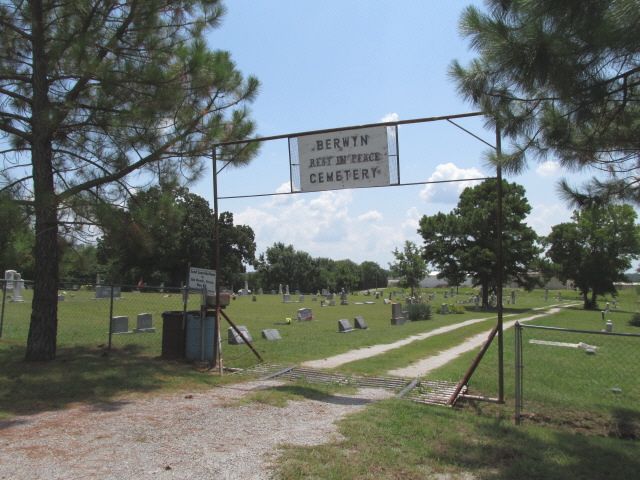
| Description | : | Gene Autry is a tiny town in Oklahoma that was renamed for the old country/western singer/actor Gene Autry. Berwyn was the original name of the town and is still the name of the cemetery as the cemetery sign shows. |
frequently asked questions (FAQ):
-
Where is Berwyn Cemetery?
Berwyn Cemetery is located at Gene Autry, Carter County ,Oklahoma ,USA.
-
Berwyn Cemetery cemetery's updated grave count on graveviews.com?
5 memorials
-
Where are the coordinates of the Berwyn Cemetery?
Latitude: 34.2848015
Longitude: -97.0421982
Nearby Cemetories:
1. Old Berwyn Cemetery
Gene Autry, Carter County, USA
Coordinate: 34.2909775, -97.0420685
2. Big Branch Cemetery
Carter County, USA
Coordinate: 34.2910995, -97.0307999
3. Abramville Cemetery
Gene Autry, Carter County, USA
Coordinate: 34.2729000, -97.0752500
4. Calvary Cemetery
Gene Autry, Carter County, USA
Coordinate: 34.3213150, -97.0451350
5. Mount Pleasant Cemetery
Gene Autry, Carter County, USA
Coordinate: 34.2517014, -97.0180969
6. Henderson Cemetery
Gene Autry, Carter County, USA
Coordinate: 34.3168983, -97.0117035
7. Hutchins Cemetery
Baum, Carter County, USA
Coordinate: 34.2712631, -96.9771805
8. Young Cemetery
Gene Autry, Carter County, USA
Coordinate: 34.2969017, -96.9760971
9. Oil Springs Cemetery
Carter County, USA
Coordinate: 34.3072100, -96.9764000
10. Goddard Cemetery
Gene Autry, Carter County, USA
Coordinate: 34.3073570, -96.9633280
11. Thomas Cemetery
Baum, Carter County, USA
Coordinate: 34.2449989, -96.9672012
12. Cole Cemetery
Ardmore, Carter County, USA
Coordinate: 34.2281560, -97.1025460
13. Big Canyon Cemetery
Murray County, USA
Coordinate: 34.3630981, -97.0255966
14. Springer Cemetery
Springer, Carter County, USA
Coordinate: 34.3129700, -97.1367000
15. Pruitt Cemetery
Ardmore, Carter County, USA
Coordinate: 34.1974983, -97.0736008
16. Maxwell-Woods Cemetery
Ardmore, Carter County, USA
Coordinate: 34.2219500, -97.1360900
17. Lone Cedar Cemetery
Johnston County, USA
Coordinate: 34.2502460, -96.9287830
18. Clearview Cemetery
Ardmore, Carter County, USA
Coordinate: 34.1878260, -97.1075960
19. Dougherty Cemetery
Dougherty, Murray County, USA
Coordinate: 34.3993200, -97.0425000
20. Cobb Cemetery
Springer, Carter County, USA
Coordinate: 34.3445560, -97.1648810
21. Drake-Nebo Cemetery
Drake, Murray County, USA
Coordinate: 34.3897018, -96.9728012
22. Glenn Cemetery
Glenn, Carter County, USA
Coordinate: 34.3067500, -97.1961000
23. Rice Cemetery
Carter County, USA
Coordinate: 34.3067500, -97.1961600
24. Nelda Cemetery
Durwood, Carter County, USA
Coordinate: 34.1749992, -96.9578018