
| Memorials | : | 26 |
| Location | : | Big Bone, Boone County, USA |
| Phone | : | (859) 384-8858 |
| Coordinate | : | 38.9217100, -84.7467300 |
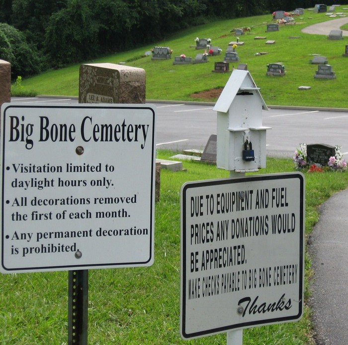
| Description | : | The cemetery is located on both sides of Gum Branch Road at its junction with Big Bone Church Road. The Boone County GIS unique ID assigned to this cemetery is 23 (Big Bone Baptist Cemetery). The cemetery has an index number of 23 (Big Bone Baptist Church Cemetery) on the Boone County Kentucky Cemetery Map published in 2005 by the Boone County Planning Commission in conjunction with Johnson-Wilson Cemetery Stewards Association. The U.S. Geological Survey (USGS) Geographic Names Information System (GNIS) feature ID for the cemetery is 2569254 (Big Bone Church Cemetery). The cemetery is identified as Big Bone Baptist Church in the... Read More |
frequently asked questions (FAQ):
-
Where is Big Bone Baptist Church Cemetery?
Big Bone Baptist Church Cemetery is located at 11036 Big Bone Church Road Big Bone, Boone County ,Kentucky , 41091USA.
-
Big Bone Baptist Church Cemetery cemetery's updated grave count on graveviews.com?
23 memorials
-
Where are the coordinates of the Big Bone Baptist Church Cemetery?
Latitude: 38.9217100
Longitude: -84.7467300
Nearby Cemetories:
1. Howlett-Glore Cemetery
Big Bone, Boone County, USA
Coordinate: 38.9023590, -84.7309120
2. Saint Joseph Mission Cemetery
Boone County, USA
Coordinate: 38.8924510, -84.7302710
3. Sullivan-Horton Cemetery
Rabbit Hash, Boone County, USA
Coordinate: 38.9353720, -84.7859060
4. Dudgeon Cemetery
Beaverlick, Boone County, USA
Coordinate: 38.8855560, -84.7383330
5. Wright Carpenter Gravesite
Big Bone, Boone County, USA
Coordinate: 38.8862590, -84.7623330
6. Baker Family Cemetery
Big Bone, Boone County, USA
Coordinate: 38.8840030, -84.7471470
7. Beech Grove Holiness Church Cemetery
Waterloo, Boone County, USA
Coordinate: 38.9518500, -84.7839100
8. Allen Cemetery
Union, Boone County, USA
Coordinate: 38.9126830, -84.8003430
9. James T Ryle Cemetery
Burlington, Boone County, USA
Coordinate: 38.9546820, -84.7824470
10. Adams-Riley Cemetery
Union, Boone County, USA
Coordinate: 38.9480560, -84.7019440
11. Tudor Marshall Cemetery
Burlington, Boone County, USA
Coordinate: 38.9639830, -84.7653020
12. Ryle Cemetery
Rabbit Hash, Boone County, USA
Coordinate: 38.9289501, -84.8035591
13. Old Ryle Homeplace Cemetery
Union, Boone County, USA
Coordinate: 38.9427780, -84.7986110
14. Powell Cemetery
Waterloo, Boone County, USA
Coordinate: 38.9581140, -84.7844440
15. Ryle Cemetery
Rabbit Hash, Boone County, USA
Coordinate: 38.9189500, -84.8080040
16. Gregory Cemetery
Rabbit Hash, Boone County, USA
Coordinate: 38.9007988, -84.8022003
17. Jimerson Craig Cemetery
Beaverlick, Boone County, USA
Coordinate: 38.9030560, -84.8041670
18. Hugh Steers Burial Site
Florence, Boone County, USA
Coordinate: 38.9340280, -84.6865210
19. Black Cemetery
Union, Boone County, USA
Coordinate: 38.8736000, -84.7605972
20. Wilson Cemetery (Defunct)
Union, Boone County, USA
Coordinate: 38.9580560, -84.7027780
21. Craig Cemetery
Beaverlick, Boone County, USA
Coordinate: 38.9064460, -84.8117250
22. Kirtley Cemetery (Defunct)
Rabbit Hash, Boone County, USA
Coordinate: 38.9064460, -84.8117250
23. Slator Cemetery
Beaverlick, Boone County, USA
Coordinate: 38.8689160, -84.7526830
24. Marshall-Bradford Cemetery
Burlington, Boone County, USA
Coordinate: 38.9688630, -84.7812320