
| Memorials | : | 11 |
| Location | : | Marion, Plymouth County, USA |
| Coordinate | : | 41.7076200, -70.7392100 |
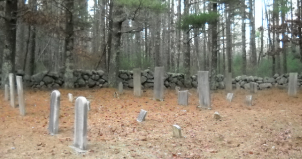
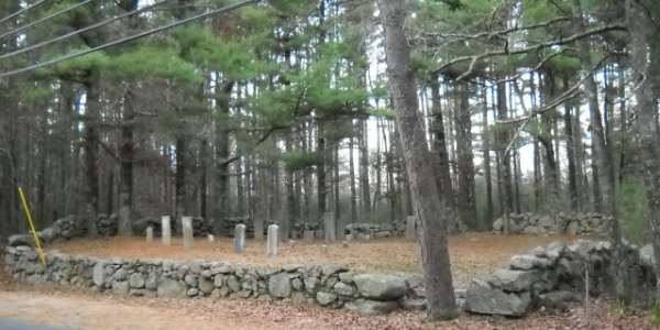
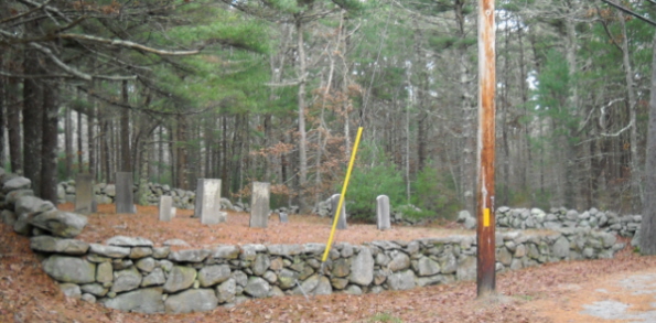
| Description | : | This is a town-owned cemetery. The break in the back stone wall leads directly into the Point Road Memorial Forest, which is a cremains-only cemetery. Note that the official documentation refers the name of this cemetery as "Blankenship" while the surnames on the stones are all spelled "Blankinship". The Massachusetts Historical Commission refers to this cemetery in MACRIS as MRN805. This burial place is referenced to in the book "Vital Records of Rochester, Massachusetts to 1850", Published by the New England Historic Genealogical Society, as G.R.15. The town of Marion separated from the town of Rochester in 1852. |
frequently asked questions (FAQ):
-
Where is Blankenship Cemetery?
Blankenship Cemetery is located at Point Road Marion, Plymouth County ,Massachusetts ,USA.
-
Blankenship Cemetery cemetery's updated grave count on graveviews.com?
11 memorials
-
Where are the coordinates of the Blankenship Cemetery?
Latitude: 41.7076200
Longitude: -70.7392100
Nearby Cemetories:
1. Point Road Memorial Forest
Marion, Plymouth County, USA
Coordinate: 41.7071400, -70.7385050
2. Saint Gabriels Episcopal Memorial Garden
Marion, Plymouth County, USA
Coordinate: 41.7020200, -70.7626500
3. Little Neck Cemetery
Marion, Plymouth County, USA
Coordinate: 41.7175200, -70.7624900
4. Old Landing Cemetery
Marion, Plymouth County, USA
Coordinate: 41.7103004, -70.7707977
5. Evergreen Cemetery
Marion, Plymouth County, USA
Coordinate: 41.6985435, -70.7698517
6. Friends Burial Ground
Marion, Plymouth County, USA
Coordinate: 41.7279129, -70.7757416
7. North Marion Cemetery
Marion, Plymouth County, USA
Coordinate: 41.7280884, -70.7763062
8. Agawam Cemetery
Wareham, Plymouth County, USA
Coordinate: 41.7463989, -70.6908035
9. Friends Cemetery
Mattapoisett, Plymouth County, USA
Coordinate: 41.6658110, -70.7838390
10. Perry Family Cemetery
Rochester, Plymouth County, USA
Coordinate: 41.7501840, -70.7914780
11. Pine Island Cemetery
Mattapoisett, Plymouth County, USA
Coordinate: 41.6624947, -70.7928925
12. Center Cemetery
Rochester, Plymouth County, USA
Coordinate: 41.7301530, -70.8185830
13. Saint Patricks Cemetery
Wareham, Plymouth County, USA
Coordinate: 41.7703018, -70.7264023
14. Centre Cemetery
Wareham, Plymouth County, USA
Coordinate: 41.7708015, -70.7277985
15. Tobey-Fearing-Bliss Cemetery (Defunct)
Wareham, Plymouth County, USA
Coordinate: 41.7722600, -70.7464100
16. Saint Anthonys Cemetery
Mattapoisett, Plymouth County, USA
Coordinate: 41.6781060, -70.8271560
17. Ellis Family Burial Ground
Rochester, Plymouth County, USA
Coordinate: 41.7105620, -70.8397580
18. Barlow Cemetery
Mattapoisett, Plymouth County, USA
Coordinate: 41.6641045, -70.8232269
19. Hillside Cemetery
Rochester, Plymouth County, USA
Coordinate: 41.7750015, -70.7889023
20. Union Cemetery
Rochester, Plymouth County, USA
Coordinate: 41.7573640, -70.8202030
21. Cushing Cemetery
Mattapoisett, Plymouth County, USA
Coordinate: 41.6624985, -70.8255997
22. Woodside Cemetery
Rochester, Plymouth County, USA
Coordinate: 41.7848816, -70.7774887
23. Hammond Cemetery
Mattapoisett, Plymouth County, USA
Coordinate: 41.6638300, -70.8351500
24. Long Neck Cemetery
Wareham, Plymouth County, USA
Coordinate: 41.7461014, -70.6369019