
| Memorials | : | 0 |
| Location | : | Hilderbrand, Douglas County, USA |
| Coordinate | : | 33.6939590, -84.6661810 |
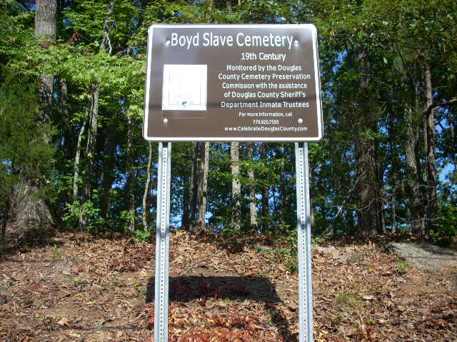
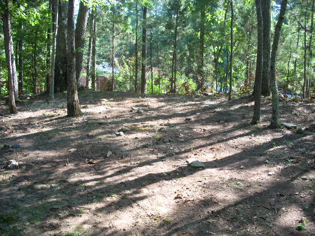
| Description | : | This small cemetery of perhaps two dozen graves was almost totally destroyed by development activity in the 1970s when Valli Hi subdivision was built. Part of the front of the hill was lost which probably included graves. All graves were marked by fieldstones, and none are now standing. Since 2008 it has been cleaned annually by an inmate crew from the Douglas County Sheriff's Office under the supervision of the Douglas County Cemetery Preservation Commission. |
frequently asked questions (FAQ):
-
Where is Boyd Slave Cemetery?
Boyd Slave Cemetery is located at Corner of Jarita Way and Hwy. 92/166 Hilderbrand, Douglas County ,Georgia , 30135USA.
-
Boyd Slave Cemetery cemetery's updated grave count on graveviews.com?
0 memorials
-
Where are the coordinates of the Boyd Slave Cemetery?
Latitude: 33.6939590
Longitude: -84.6661810
Nearby Cemetories:
1. Victory Baptist Church Cemetery
Douglasville, Douglas County, USA
Coordinate: 33.6849340, -84.6616050
2. Moss Cemetery
Hilderbrand, Douglas County, USA
Coordinate: 33.6806710, -84.6672750
3. Pleasant Grove Baptist Church Cemetery
Douglas County, USA
Coordinate: 33.7063751, -84.6582870
4. New River Community Church Cemetery
Douglasville, Douglas County, USA
Coordinate: 33.7109030, -84.6618760
5. Edenfield Family Cemetery
Douglas County, USA
Coordinate: 33.6758990, -84.6734880
6. Gorman Cemetery
Douglas County, USA
Coordinate: 33.7097851, -84.6477179
7. Connally Family Cemetery
Douglasville, Douglas County, USA
Coordinate: 33.6960240, -84.6344270
8. Old Austell Plantation Cemetery
South Fulton, Fulton County, USA
Coordinate: 33.6726270, -84.6439580
9. Believers Church Cemetery
Douglasville, Douglas County, USA
Coordinate: 33.7240261, -84.6921704
10. James Family Cemetery
Douglasville, Douglas County, USA
Coordinate: 33.7334600, -84.6792540
11. Campbellton Baptist Church Cemetery
Fairburn, Fulton County, USA
Coordinate: 33.6530100, -84.6716300
12. Old Campbellton Baptist Church Cemetery
Campbellton, Fulton County, USA
Coordinate: 33.6525300, -84.6686100
13. Brock Family Cemetery
Douglasville, Douglas County, USA
Coordinate: 33.6877190, -84.7160050
14. Friendship Baptist Church Cemetery
Campbellton, Fulton County, USA
Coordinate: 33.6519700, -84.6694300
15. Chapel Hill Cemetery
Douglasville, Douglas County, USA
Coordinate: 33.6852600, -84.7165000
16. Campbellton United Methodist Church Cemetery
Fairburn, Fulton County, USA
Coordinate: 33.6505500, -84.6723800
17. Tranquil AME Church Cemetery
Douglasville, Douglas County, USA
Coordinate: 33.6860950, -84.7221060
18. McKoy Cemetery
Douglas County, USA
Coordinate: 33.6571999, -84.7022018
19. Pepper Family Cemetery
Douglas County, USA
Coordinate: 33.7412030, -84.6818960
20. Mount Carmel Primitive Baptist Church Cemetery
Douglasville, Douglas County, USA
Coordinate: 33.7416600, -84.6823700
21. Fair View Church Cemetery
Douglasville, Douglas County, USA
Coordinate: 33.7367760, -84.6971520
22. Chapel on the Hill Cemetery
Douglasville, Douglas County, USA
Coordinate: 33.6707740, -84.7208230
23. Smith Family Cemetery
Campbellton, Fulton County, USA
Coordinate: 33.6474600, -84.6338300
24. Hornsby Family Cemetery
South Fulton, Fulton County, USA
Coordinate: 33.6472790, -84.6341100