
| Memorials | : | 0 |
| Location | : | Bradenstoke, Wiltshire Unitary Authority, England |
| Coordinate | : | 51.5122220, -2.0036110 |
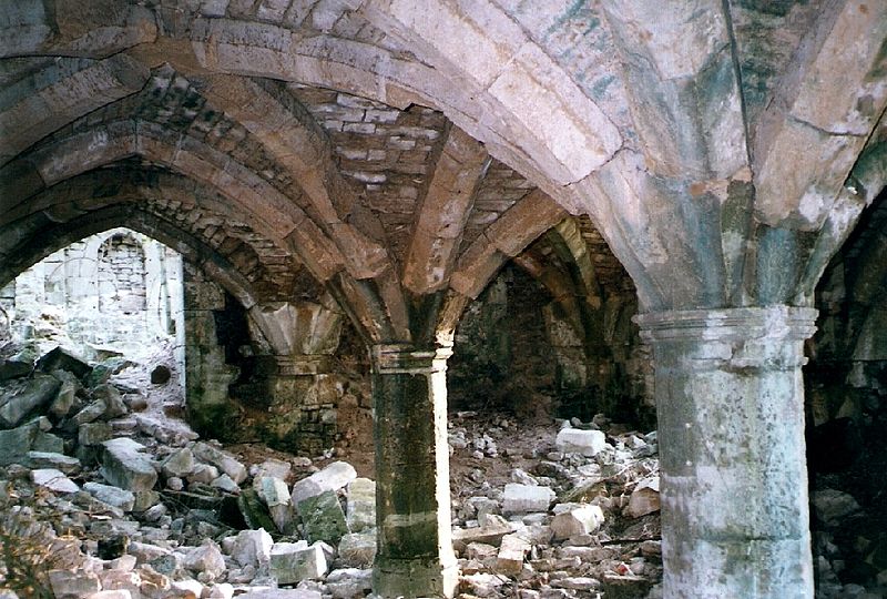
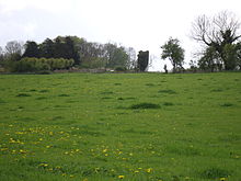
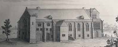
| Description | : | The priory was founded in 1142 as the Augustinian priory of Clack, and dedicated to St. Mary. It was well-sited on a high ridge near a holy well, with further springs nearby; there is some evidence that a chapel of the era of Henry I already existed at the holy well. The founder, Walter FitzEdward (otherwise D'Everaux), was the son of Edward De Evreux of Salisbury, a High Sheriff of Wiltshire; he gave lands for a priory as a daughter house of St. Mary's Abbey, Cirencester, according to its charter, "to serve God forever!". After the death of his wife, he... Read More |
frequently asked questions (FAQ):
-
Where is Bradenstoke Priory?
Bradenstoke Priory is located at Bradenstoke, Wiltshire Unitary Authority ,Wiltshire ,England.
-
Bradenstoke Priory cemetery's updated grave count on graveviews.com?
0 memorials
-
Where are the coordinates of the Bradenstoke Priory?
Latitude: 51.5122220
Longitude: -2.0036110
Nearby Cemetories:
1. Saint Mary the Virgin Churchyard
Bradenstoke, Wiltshire Unitary Authority, England
Coordinate: 51.5133061, -2.0006892
2. St John the Baptist, Foxham
Bremhill, Wiltshire Unitary Authority, England
Coordinate: 51.4939942, -2.0348493
3. St. James the Great Churchyard
Dauntsey, Wiltshire Unitary Authority, England
Coordinate: 51.5411100, -2.0301400
4. All Saints Church
Christian Malford, Wiltshire Unitary Authority, England
Coordinate: 51.5050060, -2.0586920
5. St Giles Church Tytherton Kellaways
Chippenham, Wiltshire Unitary Authority, England
Coordinate: 51.4805660, -2.0756870
6. St Peter Churchyard
Clyffe Pypard, Wiltshire Unitary Authority, England
Coordinate: 51.4917330, -1.8939970
7. Curzon Street Cemetery
Calne, Wiltshire Unitary Authority, England
Coordinate: 51.4409010, -2.0107130
8. St Swithin Churchyard
Compton Bassett, Wiltshire Unitary Authority, England
Coordinate: 51.4433640, -1.9569990
9. St Mary the Virgin Churchyard
Calne, Wiltshire Unitary Authority, England
Coordinate: 51.4371650, -2.0027540
10. All Saints Churchyard
Corston, Wiltshire Unitary Authority, England
Coordinate: 51.5543570, -2.1085990
11. Calne Holy Trinity Churchyard
Calne Without, Wiltshire Unitary Authority, England
Coordinate: 51.4303550, -1.9975930
12. Christ Church Churchyard
Broad Town, Wiltshire Unitary Authority, England
Coordinate: 51.5026474, -1.8720911
13. Christ Church
Derry Hill, Wiltshire Unitary Authority, England
Coordinate: 51.4368890, -2.0654300
14. London Road Cemetery
Chippenham, Wiltshire Unitary Authority, England
Coordinate: 51.4506852, -2.0978890
15. St. John the Baptist Churchyard
Charlton (North), Wiltshire Unitary Authority, England
Coordinate: 51.5995500, -2.0604800
16. St Paul with Allington Mission
Allington, Wiltshire Unitary Authority, England
Coordinate: 51.4753340, -2.1530720
17. Lydiard Tregoze St Mary Church
Blagrove, Swindon Unitary Authority, England
Coordinate: 51.5617700, -1.8514300
18. St John the Baptist churchyard and extension
Brokenborough, Wiltshire Unitary Authority, England
Coordinate: 51.6022576, -2.1206102
19. Chittoe Graveyard
Chippenham, Wiltshire Unitary Authority, England
Coordinate: 51.3985740, -2.0637040
20. Saint James Churchyard
Avebury, Wiltshire Unitary Authority, England
Coordinate: 51.4280700, -1.8575100
21. Avebury Chapel
Avebury, Wiltshire Unitary Authority, England
Coordinate: 51.4284210, -1.8562170
22. St John Baptist and St Helen Churchyard
Wroughton, Swindon Unitary Authority, England
Coordinate: 51.5210500, -1.8030770
23. All Saints Churchyard
Crudwell, Wiltshire Unitary Authority, England
Coordinate: 51.6349050, -2.0644280
24. St. Nicholas' Churchyard
Bromham, Wiltshire Unitary Authority, England
Coordinate: 51.3857110, -2.0543780