
| Memorials | : | 0 |
| Location | : | Bremhill, Wiltshire Unitary Authority, England |
| Coordinate | : | 51.4939942, -2.0348493 |
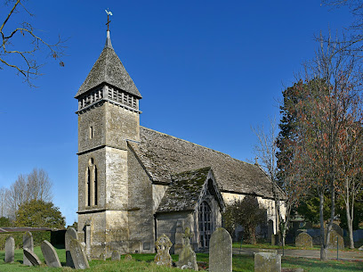
| Description | : | There is a record of Foxham being a chapelry of the parish of Bremhill and Highway by 1219.The present Church of England parish church of Saint John the Baptist was designed by the Gothic Revival architect William Butterfield and built in 1878–81.The church is Grade II* listed and has a stained glass window made in about 1855 that was part of the east window of St Martin's parish church, Bremhill. A Wesleyan chapel was built at Foxham in 1855, but it has been closed and converted into a house.[ |
frequently asked questions (FAQ):
-
Where is St John the Baptist, Foxham?
St John the Baptist, Foxham is located at Foxham Bremhill, Wiltshire Unitary Authority ,Wiltshire , SN15 4NQEngland.
-
St John the Baptist, Foxham cemetery's updated grave count on graveviews.com?
0 memorials
-
Where are the coordinates of the St John the Baptist, Foxham?
Latitude: 51.4939942
Longitude: -2.0348493
Nearby Cemetories:
1. All Saints Church
Christian Malford, Wiltshire Unitary Authority, England
Coordinate: 51.5050060, -2.0586920
2. Bradenstoke Priory
Bradenstoke, Wiltshire Unitary Authority, England
Coordinate: 51.5122220, -2.0036110
3. Saint Mary the Virgin Churchyard
Bradenstoke, Wiltshire Unitary Authority, England
Coordinate: 51.5133061, -2.0006892
4. St Giles Church Tytherton Kellaways
Chippenham, Wiltshire Unitary Authority, England
Coordinate: 51.4805660, -2.0756870
5. St. James the Great Churchyard
Dauntsey, Wiltshire Unitary Authority, England
Coordinate: 51.5411100, -2.0301400
6. Curzon Street Cemetery
Calne, Wiltshire Unitary Authority, England
Coordinate: 51.4409010, -2.0107130
7. London Road Cemetery
Chippenham, Wiltshire Unitary Authority, England
Coordinate: 51.4506852, -2.0978890
8. Christ Church
Derry Hill, Wiltshire Unitary Authority, England
Coordinate: 51.4368890, -2.0654300
9. St Mary the Virgin Churchyard
Calne, Wiltshire Unitary Authority, England
Coordinate: 51.4371650, -2.0027540
10. Calne Holy Trinity Churchyard
Calne Without, Wiltshire Unitary Authority, England
Coordinate: 51.4303550, -1.9975930
11. St Swithin Churchyard
Compton Bassett, Wiltshire Unitary Authority, England
Coordinate: 51.4433640, -1.9569990
12. All Saints Churchyard
Corston, Wiltshire Unitary Authority, England
Coordinate: 51.5543570, -2.1085990
13. St Paul with Allington Mission
Allington, Wiltshire Unitary Authority, England
Coordinate: 51.4753340, -2.1530720
14. St Peter Churchyard
Clyffe Pypard, Wiltshire Unitary Authority, England
Coordinate: 51.4917330, -1.8939970
15. Chittoe Graveyard
Chippenham, Wiltshire Unitary Authority, England
Coordinate: 51.3985740, -2.0637040
16. Christ Church Churchyard
Broad Town, Wiltshire Unitary Authority, England
Coordinate: 51.5026474, -1.8720911
17. St. John the Baptist Churchyard
Charlton (North), Wiltshire Unitary Authority, England
Coordinate: 51.5995500, -2.0604800
18. St. Nicholas' Churchyard
Biddestone, Wiltshire Unitary Authority, England
Coordinate: 51.4606100, -2.2003700
19. St. Nicholas' Churchyard
Bromham, Wiltshire Unitary Authority, England
Coordinate: 51.3857110, -2.0543780
20. Bromham Cemetery
Bromham, Wiltshire Unitary Authority, England
Coordinate: 51.3854000, -2.0538000
21. St Bartholomew Churchyard
Corsham, Wiltshire Unitary Authority, England
Coordinate: 51.4338640, -2.1822900
22. St Nicholas Churchyard Extension
Biddestone, Wiltshire Unitary Authority, England
Coordinate: 51.4586102, -2.2046090
23. St Barnabas Churchyard
Beanacre, Wiltshire Unitary Authority, England
Coordinate: 51.3936935, -2.1398827
24. St John the Baptist churchyard and extension
Brokenborough, Wiltshire Unitary Authority, England
Coordinate: 51.6022576, -2.1206102