
| Memorials | : | 0 |
| Location | : | Brougham, Eden District, England |
| Coordinate | : | 54.6493200, -2.7285300 |
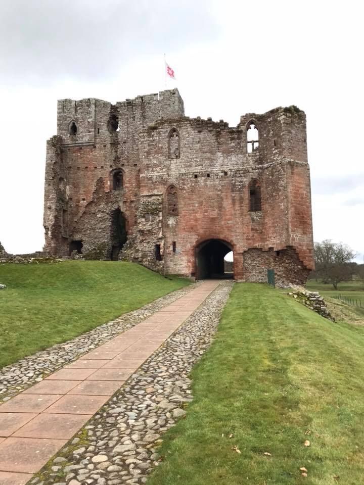
| Description | : | Brougham Castle (pronounced /ˈbruːm/) is a medieval building about 2 miles (3.2 km) south-east of Penrith, Cumbria, England. The castle was founded by Robert I de Vieuxpont in the early 13th century. The site, near the confluence of the rivers, Eamont and Lowther, had been chosen by the Romans for a Roman fort called Brocavum. The castle is scheduled as an Ancient Monument, along with the fort, as "Brougham Roman fort and Brougham Castle" |
frequently asked questions (FAQ):
-
Where is Brougham Castle?
Brougham Castle is located at Moor Lane, Penrith Brougham, Eden District ,Cumbria , CA10 2AAEngland.
-
Brougham Castle cemetery's updated grave count on graveviews.com?
0 memorials
-
Where are the coordinates of the Brougham Castle?
Latitude: 54.6493200
Longitude: -2.7285300
Nearby Cemetories:
1. Brougham Hall and St Wilfrids Chapel Grounds
Brougham, Eden District, England
Coordinate: 54.6482400, -2.7334200
2. Saint Cuthbert's Churchyard
Clifton, Eden District, England
Coordinate: 54.6361620, -2.7266804
3. St. Andrew's Churchyard
Penrith, Eden District, England
Coordinate: 54.6640750, -2.7513390
4. Penrith Quaker Meeting House
Penrith, Eden District, England
Coordinate: 54.6664360, -2.7513030
5. Christ Church
Penrith, Eden District, England
Coordinate: 54.6678290, -2.7548970
6. Beacon Edge Cemetery
Penrith, Eden District, England
Coordinate: 54.6728020, -2.7503650
7. St. Michael Churchyard
Lowther, Eden District, England
Coordinate: 54.6129190, -2.7462760
8. Saint Peter's Churchyard
Askham, Eden District, England
Coordinate: 54.6077420, -2.7476530
9. St. Michael's Churchyard
Barton, Eden District, England
Coordinate: 54.6297980, -2.7949154
10. Saint Cuthbert's Churchyard
Edenhall, Eden District, England
Coordinate: 54.6816000, -2.6700000
11. St. John Churchyard
Newton Reigny, Eden District, England
Coordinate: 54.6767560, -2.8088380
12. St Barnabas Cemetery
Great Strickland, Eden District, England
Coordinate: 54.6002670, -2.6794060
13. St. Peter's Churchyard
Langwathby, Eden District, England
Coordinate: 54.6968220, -2.6701190
14. Eden Valley Crematorium
Temple Sowerby, Eden District, England
Coordinate: 54.6451850, -2.6237780
15. St Cuthbert Churchyard
Cliburn, Eden District, England
Coordinate: 54.6138700, -2.6399030
16. Langwathby Cemetery
Langwathby, Eden District, England
Coordinate: 54.7043400, -2.6750620
17. St Andrew's Churchyard
Dacre, Eden District, England
Coordinate: 54.6319910, -2.8380460
18. All Saints Churchyard
Culgaith, Eden District, England
Coordinate: 54.6606090, -2.6059000
19. Saint James Churchyard
Temple Sowerby, Eden District, England
Coordinate: 54.6378210, -2.6033040
20. Saint Cuthbert Churchyard
Great Salkeld, Eden District, England
Coordinate: 54.7239460, -2.6978280
21. St. Lawrence Churchyard
Morland, Eden District, England
Coordinate: 54.5964730, -2.6235880
22. St. Andrew Churchyard
Greystoke, Eden District, England
Coordinate: 54.6690130, -2.8645240
23. St John the Evangelist Churchyard
Hesket, Eden District, England
Coordinate: 54.7268660, -2.7821200
24. St Mary Churchyard
Thrimby, Eden District, England
Coordinate: 54.5708750, -2.6782120