
| Memorials | : | 10 |
| Location | : | Robbins, Moore County, USA |
| Coordinate | : | 35.4284520, -79.6502140 |
frequently asked questions (FAQ):
-
Where is Browns Chapel Christian Church Cemetery?
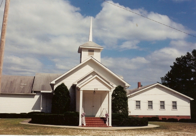
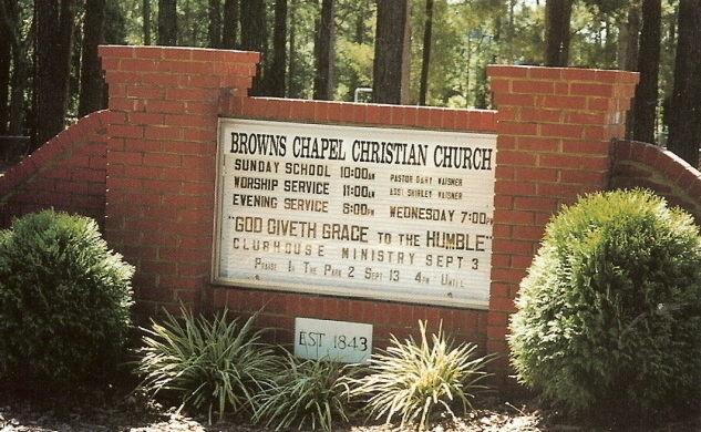
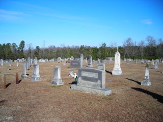
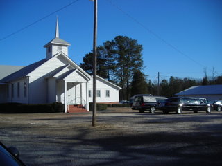
Browns Chapel Christian Church Cemetery is located at 619 Browns Chapel Road Robbins, Moore County ,North Carolina , 27325USA.
-
Browns Chapel Christian Church Cemetery cemetery's updated grave count on graveviews.com?
10 memorials
-
Where are the coordinates of the Browns Chapel Christian Church Cemetery?
Latitude: 35.4284520
Longitude: -79.6502140
Nearby Cemetories:
1. Bascom Chapel United Methodist Church Cemetery
Robbins, Moore County, USA
Coordinate: 35.4393080, -79.6755880
2. Morgan Family Cemetery
Robbins, Moore County, USA
Coordinate: 35.4054490, -79.6552348
3. Melton family cemetery
Robbins, Moore County, USA
Coordinate: 35.4404412, -79.6787718
4. Hardy Sanders Gravesite
Robbins, Moore County, USA
Coordinate: 35.4015758, -79.6445489
5. Owen/Brewer camp meeting cemetery
Robbins, Moore County, USA
Coordinate: 35.4408422, -79.6820429
6. Guiding Light Baptist Church Cemetery
Robbins, Moore County, USA
Coordinate: 35.4202520, -79.6899960
7. Pine Grove Baptist Church Cemetery
Eagle Springs, Moore County, USA
Coordinate: 35.3904890, -79.6594410
8. Old John Key Cemetery
Spies, Moore County, USA
Coordinate: 35.3864611, -79.6414389
9. Williamson-Key Cemetery
Spies, Moore County, USA
Coordinate: 35.3898083, -79.6724583
10. Acorn Ridge Baptist Church Cemetery
Robbins, Moore County, USA
Coordinate: 35.4623750, -79.6120810
11. Pleasant View Friends Church Cemetery
Eagle Springs, Moore County, USA
Coordinate: 35.4003400, -79.6049900
12. George Davis Cemetery
Robbins, Moore County, USA
Coordinate: 35.4159672, -79.5941860
13. Davis Family Cemetery
Dover, Moore County, USA
Coordinate: 35.4298300, -79.7088600
14. Sowell Family Cemetery
Robbins, Moore County, USA
Coordinate: 35.4062360, -79.5947134
15. Allred Family Cemetery
Westmore, Moore County, USA
Coordinate: 35.4769500, -79.6687400
16. Deaton Cemetery
Robbins, Moore County, USA
Coordinate: 35.3775466, -79.6436082
17. Little Oak Church of God Cemetery
Robbins, Moore County, USA
Coordinate: 35.4773960, -79.6720470
18. Tabernacle United Methodist Church Cemetery
Robbins, Moore County, USA
Coordinate: 35.4306200, -79.5850470
19. Allen Family Cemetery
Eagle Springs, Moore County, USA
Coordinate: 35.3922500, -79.7005300
20. Williams-Morgan Cemetery
Eagle Springs, Moore County, USA
Coordinate: 35.3872530, -79.6047342
21. New Zion Hill Cemetery
Moore County, USA
Coordinate: 35.4743996, -79.6031036
22. Matthew Williams Cemetery
Robbins, Moore County, USA
Coordinate: 35.4098309, -79.5773649
23. Pine Rest Cemetery
Robbins, Moore County, USA
Coordinate: 35.4356003, -79.5738983
24. Crossroads Baptist Church Cemetery
Robbins, Moore County, USA
Coordinate: 35.4094700, -79.5763900