
| Memorials | : | 0 |
| Location | : | Harris Township, Centre County, USA |
| Coordinate | : | 40.7900000, -77.7414110 |
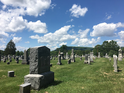
| Description | : | Also known as Old Stanford Graveyard. This cemetery is variously known as Benner Hill, Old Stanford, and Cedar Creek. According to Linn, it is the oldest burial place in Harris Township and is located on what was called " Benner's Hill" near the road leading from Boalsburg to Old Ford ( Modern day Pa route 45). An acre of land was donated by General Pottery for burial purposes, It was in general use for many years and likely holds the remains of the earliest settlers, despite there being very few stones remaining. Linn states that the remaining... Read More |
frequently asked questions (FAQ):
-
Where is Cedar Creek Cemetery?
Cedar Creek Cemetery is located at Sharer Road Harris Township, Centre County ,Pennsylvania , 16827USA.
-
Cedar Creek Cemetery cemetery's updated grave count on graveviews.com?
0 memorials
-
Where are the coordinates of the Cedar Creek Cemetery?
Latitude: 40.7900000
Longitude: -77.7414110
Nearby Cemetories:
1. Rock Hill Cemetery
Linden Hall, Centre County, USA
Coordinate: 40.8001000, -77.7627000
2. Boalsburg Cemetery
Boalsburg, Centre County, USA
Coordinate: 40.7787000, -77.7952000
3. Columbus Chapel - Boal Family Vault
Boalsburg, Centre County, USA
Coordinate: 40.7789900, -77.7993130
4. Zion Hill Cemetery
Centre County, USA
Coordinate: 40.7904000, -77.6793600
5. Emmanuel Union Cemetery
Tusseyville, Centre County, USA
Coordinate: 40.7987000, -77.6778000
6. Dale Cemetery
Lemont, Centre County, USA
Coordinate: 40.8070000, -77.8100000
7. Fruittown Cemetery
Centre Hall, Centre County, USA
Coordinate: 40.7764315, -77.6672651
8. Centre County Memorial Park
State College, Centre County, USA
Coordinate: 40.8377991, -77.7983017
9. Shiloh Cemetery
Centre County, USA
Coordinate: 40.8365000, -77.8011000
10. Reformed and Lutheran Cemetery
Centre Hall, Centre County, USA
Coordinate: 40.8462410, -77.6895828
11. Spring Creek Presbyterian Cemetery
State College, Centre County, USA
Coordinate: 40.7975006, -77.8349991
12. Houserville Cemetery
Houserville, Centre County, USA
Coordinate: 40.8264999, -77.8304977
13. Centre Hill Presbyterian Cemetery
Potters Mills, Centre County, USA
Coordinate: 40.8182300, -77.6469500
14. Lutheran Church Cemetery
Pleasant Gap, Centre County, USA
Coordinate: 40.8680000, -77.7497000
15. Pennington Cemetery
Centre Hall, Centre County, USA
Coordinate: 40.8562820, -77.6778240
16. Benner Cemetery
Centre County, USA
Coordinate: 40.8525009, -77.8182983
17. Grace Lutheran Church Columbarium
State College, Centre County, USA
Coordinate: 40.7969950, -77.8547510
18. Indian Lane Grave
Old Fort, Centre County, USA
Coordinate: 40.8402000, -77.6469000
19. Sprucetown Cemetery
Centre County, USA
Coordinate: 40.8090000, -77.6272000
20. Saint Andrew's Episcopal Church Columbarium
State College, Centre County, USA
Coordinate: 40.7907300, -77.8598700
21. State College Presbyterian Church Columbarium
Centre County, USA
Coordinate: 40.7925140, -77.8610750
22. Atherton Burial Site
State College, Centre County, USA
Coordinate: 40.7966780, -77.8638390
23. Egg Hill Cemetery
Centre County, USA
Coordinate: 40.8284000, -77.6250000
24. Huston Cemetery
Centre Hall, Centre County, USA
Coordinate: 40.8586430, -77.6498740