
| Memorials | : | 0 |
| Location | : | Linden Hall, Centre County, USA |
| Coordinate | : | 40.8001000, -77.7627000 |
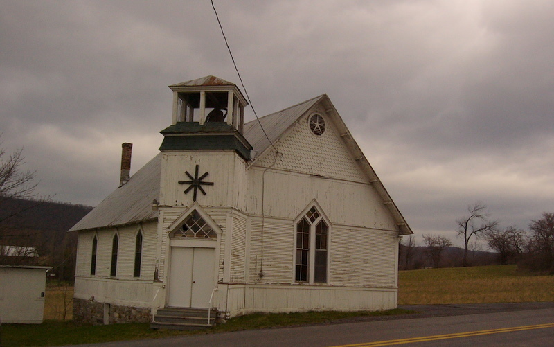
| Description | : | Rock Hill Cemetery was established in 1836 on a corner of the Johathan Dressler farm and became the final resting place for Linden Hall's earliest settlers. According to Linn, the Evangelical Church in Linden Hall was built about 1850. The booklet Sketches of Linden Hall indicated that the land was deeded from the Dresslers in 1853 for the purpose of a church. During 1880 a schism developed in the conference of the Evangelical Association churches, and two factions emerged-- The Esherites and the Dubsites. Eventually the Esherite branch prevailed and filed legal claim to the church... Read More |
frequently asked questions (FAQ):
-
Where is Rock Hill Cemetery?
Rock Hill Cemetery is located at Linden Hall, Centre County ,Pennsylvania ,USA.
-
Rock Hill Cemetery cemetery's updated grave count on graveviews.com?
0 memorials
-
Where are the coordinates of the Rock Hill Cemetery?
Latitude: 40.8001000
Longitude: -77.7627000
Nearby Cemetories:
1. Cedar Creek Cemetery
Harris Township, Centre County, USA
Coordinate: 40.7900000, -77.7414110
2. Boalsburg Cemetery
Boalsburg, Centre County, USA
Coordinate: 40.7787000, -77.7952000
3. Columbus Chapel - Boal Family Vault
Boalsburg, Centre County, USA
Coordinate: 40.7789900, -77.7993130
4. Dale Cemetery
Lemont, Centre County, USA
Coordinate: 40.8070000, -77.8100000
5. Centre County Memorial Park
State College, Centre County, USA
Coordinate: 40.8377991, -77.7983017
6. Shiloh Cemetery
Centre County, USA
Coordinate: 40.8365000, -77.8011000
7. Spring Creek Presbyterian Cemetery
State College, Centre County, USA
Coordinate: 40.7975006, -77.8349991
8. Houserville Cemetery
Houserville, Centre County, USA
Coordinate: 40.8264999, -77.8304977
9. Zion Hill Cemetery
Centre County, USA
Coordinate: 40.7904000, -77.6793600
10. Emmanuel Union Cemetery
Tusseyville, Centre County, USA
Coordinate: 40.7987000, -77.6778000
11. Benner Cemetery
Centre County, USA
Coordinate: 40.8525009, -77.8182983
12. Lutheran Church Cemetery
Pleasant Gap, Centre County, USA
Coordinate: 40.8680000, -77.7497000
13. Grace Lutheran Church Columbarium
State College, Centre County, USA
Coordinate: 40.7969950, -77.8547510
14. Reformed and Lutheran Cemetery
Centre Hall, Centre County, USA
Coordinate: 40.8462410, -77.6895828
15. Saint Andrew's Episcopal Church Columbarium
State College, Centre County, USA
Coordinate: 40.7907300, -77.8598700
16. State College Presbyterian Church Columbarium
Centre County, USA
Coordinate: 40.7925140, -77.8610750
17. Fruittown Cemetery
Centre Hall, Centre County, USA
Coordinate: 40.7764315, -77.6672651
18. Atherton Burial Site
State College, Centre County, USA
Coordinate: 40.7966780, -77.8638390
19. Pennington Cemetery
Centre Hall, Centre County, USA
Coordinate: 40.8562820, -77.6778240
20. Centre Hill Presbyterian Cemetery
Potters Mills, Centre County, USA
Coordinate: 40.8182300, -77.6469500
21. Pine Hall Cemetery
State College, Centre County, USA
Coordinate: 40.7779000, -77.8841000
22. Indian Lane Grave
Old Fort, Centre County, USA
Coordinate: 40.8402000, -77.6469000
23. Meyer Cemetery
Buffalo Run, Centre County, USA
Coordinate: 40.8736000, -77.8475037
24. Old Pine Hall Cemetery
State College, Centre County, USA
Coordinate: 40.7743000, -77.8885000