
| Memorials | : | 0 |
| Location | : | Millbrook, Cole County, USA |
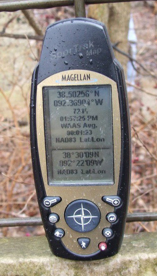
| Coordinate | : | 38.5025600, -92.3690400 |
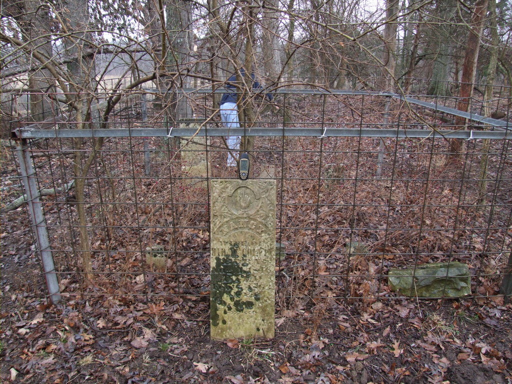
| Description | : | Township 43 N - Range 13 W - Sec. 9 Well off the road in a cow pasture behind a farmhouse. There is a sign on the road, near the driveway, identifying the cemetery. The four visible tombstones are surrounded by a 6 foot tall stock fence that is approximately 8 feet square. |
frequently asked questions (FAQ):
-
Where is Colvin Strong Cemetery?
Colvin Strong Cemetery is located at Millbrook, Cole County ,Missouri ,USA.
-
Colvin Strong Cemetery cemetery's updated grave count on graveviews.com?
0 memorials
-
Where are the coordinates of the Colvin Strong Cemetery?
Latitude: 38.5025600
Longitude: -92.3690400
Nearby Cemetories:
1. Saint Johns Lutheran Church Cemetery
Stringtown, Cole County, USA
Coordinate: 38.5192986, -92.3526993
2. Clibourn Cemetery
Russellville, Cole County, USA
Coordinate: 38.4760500, -92.3973500
3. Saint Pauls Lutheran Cemetery
Lohman, Cole County, USA
Coordinate: 38.5388985, -92.3597031
4. Blank Cemetery
Russellville, Cole County, USA
Coordinate: 38.5203018, -92.4180984
5. Pleasant Hill Cemetery
Brazito, Cole County, USA
Coordinate: 38.4810300, -92.3224000
6. Old Catholic Cemetery
Jefferson City, Cole County, USA
Coordinate: 38.5358009, -92.3321991
7. Saint Joseph Cemetery
Stringtown, Cole County, USA
Coordinate: 38.5361110, -92.3320720
8. Trinity Lutheran Cemetery
Russellville, Cole County, USA
Coordinate: 38.5028000, -92.4317017
9. Campbell Cemetery
Cole County, USA
Coordinate: 38.4810982, -92.4297028
10. Buckner Russell Cemetery
Cole County, USA
Coordinate: 38.5136900, -92.4359390
11. Gordon Cemetery
Lohman, Cole County, USA
Coordinate: 38.5370900, -92.3158100
12. Roark Cemetery
Russellville, Cole County, USA
Coordinate: 38.4696999, -92.4255981
13. Russellville Cemetery
Russellville, Cole County, USA
Coordinate: 38.5196991, -92.4366989
14. Saint Michael Cemetery
Russellville, Cole County, USA
Coordinate: 38.5109300, -92.4429100
15. Evangelical Lutheran Cemetery One Acre
Russellville, Cole County, USA
Coordinate: 38.5175667, -92.4415817
16. Johnston Cemetery
Brazito, Cole County, USA
Coordinate: 38.4928017, -92.2910995
17. Mount Carmel Cemetery
Brazito, Cole County, USA
Coordinate: 38.4398499, -92.3734207
18. Barnhardt Cemetery
Lohman, Cole County, USA
Coordinate: 38.5537900, -92.4267100
19. Raithel Cemetery
Brazito, Cole County, USA
Coordinate: 38.4420300, -92.3272400
20. Plummer Burying Ground
Jefferson City, Cole County, USA
Coordinate: 38.5633800, -92.3247900
21. Peace Lutheran Cemetery
Brazito, Cole County, USA
Coordinate: 38.4676600, -92.2889300
22. Stone Cemetery
Cole County, USA
Coordinate: 38.5718994, -92.3358002
23. Wilkerson Cemetery
Cole County, USA
Coordinate: 38.5722008, -92.3308029
24. Helton Farm Burial Ground
Hickory Hill, Cole County, USA
Coordinate: 38.4288500, -92.3464100