
| Memorials | : | 0 |
| Location | : | Doetinchem, Doetinchem Municipality, Netherlands |
| Coordinate | : | 51.9716500, 6.2851300 |
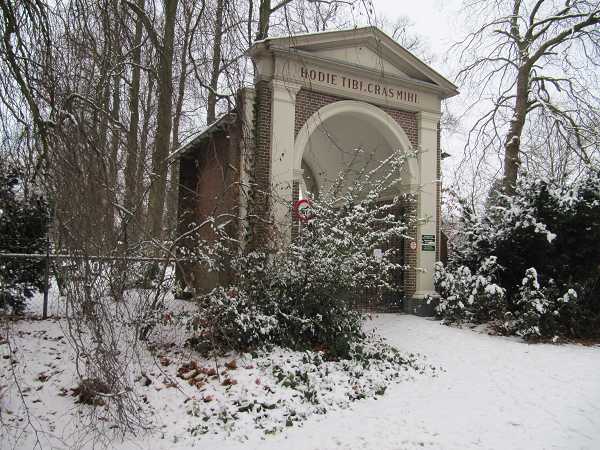
| Description | : | Doetinchem is a small town about 30 kilometres east of Arnhem, on the main road to Zutphen. The general cemetery known as Loolaan is north-west of the town, 300 metres north of the road to Arnhem. |
frequently asked questions (FAQ):
-
Where is Doetinchem General Cemetery, Loolaan?
Doetinchem General Cemetery, Loolaan is located at Doetinchem, Doetinchem Municipality ,Gelderland ,Netherlands.
-
Doetinchem General Cemetery, Loolaan cemetery's updated grave count on graveviews.com?
0 memorials
-
Where are the coordinates of the Doetinchem General Cemetery, Loolaan?
Latitude: 51.9716500
Longitude: 6.2851300
Nearby Cemetories:
1. Joodse Begraafplaats
Doetinchem Municipality, Netherlands
Coordinate: 51.9719000, 6.2936000
2. Begraafplaats Kommendijk
Doetinchem Municipality, Netherlands
Coordinate: 51.9640325, 6.3423601
3. Hummelo-en-Keppel General Cemetery
Hummelo, Bronckhorst Municipality, Netherlands
Coordinate: 52.0024000, 6.2432600
4. Kilder Roman Catholic Cemetery
Kilder, Montferland Municipality, Netherlands
Coordinate: 51.9373400, 6.2321900
5. Zelhem General Cemetery
Zelhem, Bronckhorst Municipality, Netherlands
Coordinate: 52.0097400, 6.3484600
6. Zeddam Protestant Cemetery
Zeddam, Montferland Municipality, Netherlands
Coordinate: 51.9078900, 6.2566400
7. Joodse Begraafplaats
Terborg, Oude Ijsselstreek Municipality, Netherlands
Coordinate: 51.9177220, 6.3725280
8. Hengelo Gelderland General Cemetery
Hengelo, Bronckhorst Municipality, Netherlands
Coordinate: 52.0497300, 6.3137100
9. Beek Roman Catholic Churchyard
Beek, Montferland Municipality, Netherlands
Coordinate: 51.9078300, 6.1895100
10. Halle Protestant Cemetery
Halle, Bronckhorst Municipality, Netherlands
Coordinate: 51.9921000, 6.4249400
11. Didam Protestant Cemetery
Didam, Montferland Municipality, Netherlands
Coordinate: 51.9360100, 6.1345300
12. Doesburg Begraafplaats
Doesburg, Doesburg Municipality, Netherlands
Coordinate: 52.0152462, 6.1396174
13. Steenderen General Cemetery
Steenderen, Bronckhorst Municipality, Netherlands
Coordinate: 52.0642600, 6.1848700
14. Joodse Begraafsplaats Oude Ijsselstreek
Gendringen, Oude Ijsselstreek Municipality, Netherlands
Coordinate: 51.8782250, 6.3860750
15. Hervormde Begraafplaats
Gendringen, Oude Ijsselstreek Municipality, Netherlands
Coordinate: 51.8710900, 6.3661700
16. Gendringen Roman Catholic Cemetery
Gendringen, Oude Ijsselstreek Municipality, Netherlands
Coordinate: 51.8741900, 6.3785500
17. Baak Roman Catholic Cemetery
Baak, Bronckhorst Municipality, Netherlands
Coordinate: 52.0792600, 6.2253100
18. Varsseveld General Cemetery
Varsseveld, Oude Ijsselstreek Municipality, Netherlands
Coordinate: 51.9402100, 6.4632300
19. Sint-Willibrorduskerkhof
Wichmond, Bronckhorst Municipality, Netherlands
Coordinate: 52.0931500, 6.2545600
20. Olburgen Roman Catholic Cemetery
Olburgen, Bronckhorst Municipality, Netherlands
Coordinate: 52.0440100, 6.1235300
21. Joodse Begraafplaats
Zevenaar Municipality, Netherlands
Coordinate: 51.9310110, 6.0825120
22. Friedhof Emmerich
Emmerich, Kreis Kleve, Germany
Coordinate: 51.8393300, 6.2479200
23. Jüdischer Friedhof
Emmerich, Kreis Kleve, Germany
Coordinate: 51.8370156, 6.2535498
24. Zevenaar Roman Catholic Cemetery
Zevenaar, Zevenaar Municipality, Netherlands
Coordinate: 51.9289700, 6.0732300