
| Memorials | : | 1 |
| Location | : | Gendringen, Oude Ijsselstreek Municipality, Netherlands |
| Coordinate | : | 51.8741900, 6.3785500 |
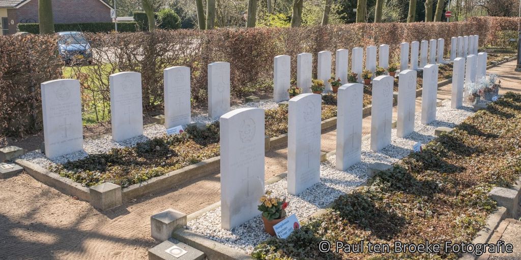
| Description | : | Gendringen is a village on the Dutch-German border, 30 kilometres east-south-east of Arnhem and 15 kilometres south-east of Doetinchem. The cemetery is behind the church of St. Martinus, which stands in the centre of Gendringen. A plot with 30 Commonwealth casaulties of World War Two is near the eastern boundary wall. |
frequently asked questions (FAQ):
-
Where is Gendringen Roman Catholic Cemetery?
Gendringen Roman Catholic Cemetery is located at Gendringen, Oude Ijsselstreek Municipality ,Gelderland ,Netherlands.
-
Gendringen Roman Catholic Cemetery cemetery's updated grave count on graveviews.com?
1 memorials
-
Where are the coordinates of the Gendringen Roman Catholic Cemetery?
Latitude: 51.8741900
Longitude: 6.3785500
Nearby Cemetories:
1. Joodse Begraafsplaats Oude Ijsselstreek
Gendringen, Oude Ijsselstreek Municipality, Netherlands
Coordinate: 51.8782250, 6.3860750
2. Hervormde Begraafplaats
Gendringen, Oude Ijsselstreek Municipality, Netherlands
Coordinate: 51.8710900, 6.3661700
3. Joodse Begraafplaats
Terborg, Oude Ijsselstreek Municipality, Netherlands
Coordinate: 51.9177220, 6.3725280
4. Emmerich-Praest
Emmerich, Kreis Kleve, Germany
Coordinate: 51.8207211, 6.3454678
5. Joodse Begraafplaats
Dinxperlo, Aalten Municipality, Netherlands
Coordinate: 51.8587400, 6.4797200
6. Dinxperlo General Cemetery
Dinxperlo, Aalten Municipality, Netherlands
Coordinate: 51.8636700, 6.4893000
7. Nieuwe Begraafplaats
Dinxperlo, Aalten Municipality, Netherlands
Coordinate: 51.8688335, 6.4971512
8. Emmerich-Dornick
Emmerich, Kreis Kleve, Germany
Coordinate: 51.8110340, 6.3060959
9. Zeddam Protestant Cemetery
Zeddam, Montferland Municipality, Netherlands
Coordinate: 51.9078900, 6.2566400
10. Varsseveld General Cemetery
Varsseveld, Oude Ijsselstreek Municipality, Netherlands
Coordinate: 51.9402100, 6.4632300
11. Jüdischer Friedhof
Emmerich, Kreis Kleve, Germany
Coordinate: 51.8370156, 6.2535498
12. Friedhof Emmerich
Emmerich, Kreis Kleve, Germany
Coordinate: 51.8393300, 6.2479200
13. Begraafplaats Kommendijk
Doetinchem Municipality, Netherlands
Coordinate: 51.9640325, 6.3423601
14. Friedhof Haus Aspel
Aspel, Kreis Kleve, Germany
Coordinate: 51.7734610, 6.4325830
15. Kilder Roman Catholic Cemetery
Kilder, Montferland Municipality, Netherlands
Coordinate: 51.9373400, 6.2321900
16. Joodse Begraafplaats
Doetinchem Municipality, Netherlands
Coordinate: 51.9719000, 6.2936000
17. Doetinchem General Cemetery, Loolaan
Doetinchem, Doetinchem Municipality, Netherlands
Coordinate: 51.9716500, 6.2851300
18. Halle Protestant Cemetery
Halle, Bronckhorst Municipality, Netherlands
Coordinate: 51.9921000, 6.4249400
19. Beek Roman Catholic Churchyard
Beek, Montferland Municipality, Netherlands
Coordinate: 51.9078300, 6.1895100
20. Aalten Rooms-Katholieke Begraafplaats
Aalten, Aalten Municipality, Netherlands
Coordinate: 51.9218500, 6.5784000
21. Oude Begraafplaats
Aalten, Aalten Municipality, Netherlands
Coordinate: 51.9283288, 6.5776327
22. Berkenhove General Cemetery
Aalten, Aalten Municipality, Netherlands
Coordinate: 51.9342100, 6.5758700
23. Zelhem General Cemetery
Zelhem, Bronckhorst Municipality, Netherlands
Coordinate: 52.0097400, 6.3484600
24. Friedhof Griethausen
Sinstorf, Harburg, Germany
Coordinate: 51.8213100, 6.1664800