| Memorials | : | 1 |
| Location | : | Forest City, Rutherford County, USA |
| Coordinate | : | 35.2808050, -81.8686810 |
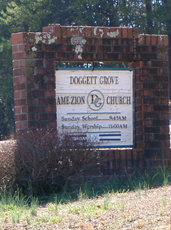
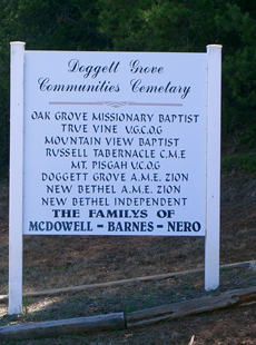
| Description | : | This cemetery is one of a cluster of church cemeteries. There is one sign for all of the cemeteries, labeling them the Doggett Grove Community Cemeteries. There are no boundaries between the cemeteries, but each is owned by each church separately. |
frequently asked questions (FAQ):
-
Where is Doggett Grove AME Zion Cemetery?
Doggett Grove AME Zion Cemetery is located at Dawkins-McDowell Road Forest City, Rutherford County ,North Carolina ,USA.
-
Doggett Grove AME Zion Cemetery cemetery's updated grave count on graveviews.com?
1 memorials
-
Where are the coordinates of the Doggett Grove AME Zion Cemetery?
Latitude: 35.2808050
Longitude: -81.8686810
Nearby Cemetories:
1. New Bethel AME Zion Cemetery
Forest City, Rutherford County, USA
Coordinate: 35.2816470, -81.8682090
2. New Bethel Independent Church Cemetery
Forest City, Rutherford County, USA
Coordinate: 35.2802970, -81.8657590
3. Doggett Cemetery
Forest City, Rutherford County, USA
Coordinate: 35.2932710, -81.8780670
4. Trout Family Cemetery
Sandy Mush, Rutherford County, USA
Coordinate: 35.2762150, -81.8428660
5. Morning Star Baptist Cemetery
Forest City, Rutherford County, USA
Coordinate: 35.2851830, -81.8952620
6. Sulphur Springs Baptist Cemetery
Harris, Rutherford County, USA
Coordinate: 35.2646130, -81.8917710
7. Morrow Curve Cemetery
Alexander Mills, Rutherford County, USA
Coordinate: 35.3007300, -81.8490800
8. Sulphur Springs Holiness Cemetery
Danieltown, Rutherford County, USA
Coordinate: 35.2844250, -81.9004050
9. Alexander Mills Cemetery
Alexander Mills, Rutherford County, USA
Coordinate: 35.3059100, -81.8566200
10. Bethany Baptist Church Cemetery
Forest City, Rutherford County, USA
Coordinate: 35.3029200, -81.8933260
11. McDonald Family Cemetery
Forest City, Rutherford County, USA
Coordinate: 35.3075850, -81.8876240
12. New Bethel Baptist Cemetery
Forest City, Rutherford County, USA
Coordinate: 35.2505264, -81.8770294
13. Tanners Grove United Methodist Cemetery
Rutherford County, USA
Coordinate: 35.2905410, -81.9049720
14. Mount Pleasant Baptist Cemetery
Sandy Mush, Rutherford County, USA
Coordinate: 35.3026220, -81.8395470
15. Providence United Methodist Church Cemetery
Forest City, Rutherford County, USA
Coordinate: 35.2633018, -81.8305969
16. Hopewell AME Zion Church Cemetery
Harris, Rutherford County, USA
Coordinate: 35.2426750, -81.8690230
17. Harris First Baptist Cemetery
Harris, Rutherford County, USA
Coordinate: 35.2428850, -81.8752240
18. Rutherford County Memorial Cemetery
Forest City, Rutherford County, USA
Coordinate: 35.2463989, -81.8443985
19. Danieltown Baptist Church Cemetery
Danieltown, Rutherford County, USA
Coordinate: 35.2977100, -81.9127880
20. Jerusalem Baptist Church Cemetery
Forest City, Rutherford County, USA
Coordinate: 35.2417000, -81.8553200
21. Word of Faith Fellowship Cemetery
Spindale, Rutherford County, USA
Coordinate: 35.2931390, -81.9189950
22. Wesley Chapel Memorial Cemetery
Harris, Rutherford County, USA
Coordinate: 35.2369960, -81.8734430
23. Floyd's Creek Baptist Church Cemetery
Forest City, Rutherford County, USA
Coordinate: 35.2386017, -81.8491974
24. Morrow Cemetery
Forest City, Rutherford County, USA
Coordinate: 35.3216800, -81.8361000


