
| Memorials | : | 4 |
| Location | : | Chilcompton, Mendip District, England |
| Coordinate | : | 51.2517300, -2.5152400 |
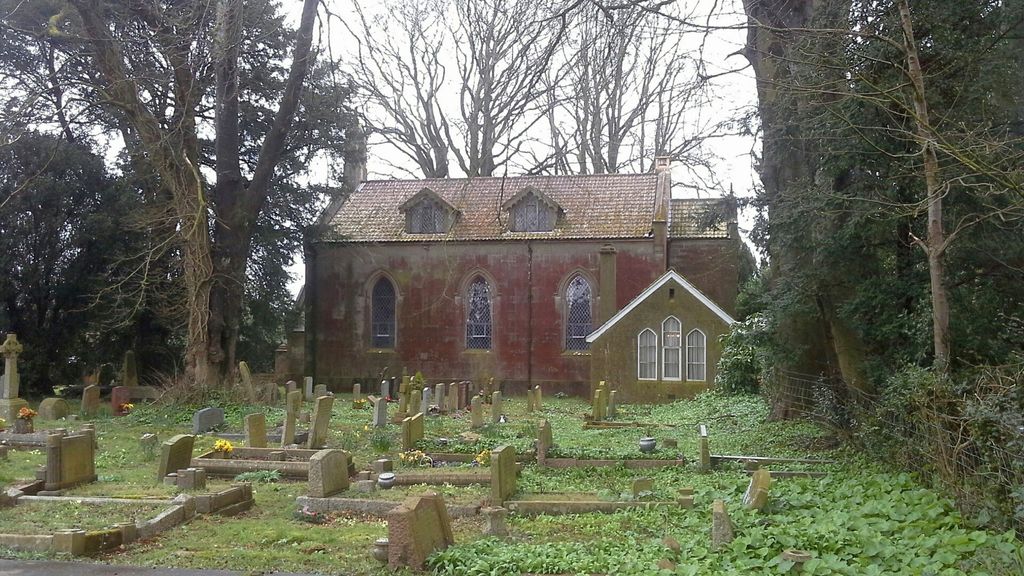
| Description | : | The former Christ Church at 148 Stockhill Road in Chilcompton was built in 1838 by John Pinch the Younger for the Downside Parish. It was a Commissioners church, which means that it was built under the Church Building Acts of 1818 and 1824, wherein money was voted by Parliament for the building of new community churches. Although the building is no longer used for religious functions, the cemetery remains in good shape and is well cared for. It is easily confused with the nearby Downside Abbey, also known as Christ Church, which is located about a mile to the east... Read More |
frequently asked questions (FAQ):
-
Where is Downside Cemetery?
Downside Cemetery is located at 148 Stockhill Road Chilcompton, Mendip District ,Somerset ,England.
-
Downside Cemetery cemetery's updated grave count on graveviews.com?
4 memorials
-
Where are the coordinates of the Downside Cemetery?
Latitude: 51.2517300
Longitude: -2.5152400
Nearby Cemetories:
1. Christ Church, Downside
Chilcompton, Mendip District, England
Coordinate: 51.2515150, -2.5153030
2. Christ Church Churchyard
Mendip District, England
Coordinate: 51.2514920, -2.5151540
3. Downside Abbey
Stratton-on-the-Fosse, Mendip District, England
Coordinate: 51.2544000, -2.4943000
4. St. Benedict's Churchyard
Stratton-on-the-Fosse, Mendip District, England
Coordinate: 51.2560684, -2.4913545
5. Saint Vigor Churchyard
Stratton-on-the-Fosse, Mendip District, England
Coordinate: 51.2552000, -2.4896000
6. St John the Baptist Church Cemetery
Chilcompton, Mendip District, England
Coordinate: 51.2693960, -2.5073780
7. St James Churchyard
Ashwick, Mendip District, England
Coordinate: 51.2320800, -2.5229500
8. St. Andrew's Churchyard
Holcombe, Mendip District, England
Coordinate: 51.2547850, -2.4760280
9. Holy Trinity Churchyard
Binegar, Mendip District, England
Coordinate: 51.2425530, -2.5524812
10. St. Mary the Virgin Churchyard
Emborough, Mendip District, England
Coordinate: 51.2600970, -2.5539150
11. St Mary The Virgin Churchyard
Ston Easton, Mendip District, England
Coordinate: 51.2788400, -2.5404390
12. Saint Mary the Virgin Church
Ston Easton, Mendip District, England
Coordinate: 51.2789610, -2.5407720
13. St Michael & All Angels
Stoke St Michael, Mendip District, England
Coordinate: 51.2208300, -2.4819900
14. St. John the Baptist Churchyard
Midsomer Norton, Bath and North East Somerset Unitary Authority, England
Coordinate: 51.2870310, -2.4842190
15. Holy Trinity Churchyard
Coleford, Mendip District, England
Coordinate: 51.2394100, -2.4503100
16. St Mary Magdalene Churchyard
Chewton Mendip, Mendip District, England
Coordinate: 51.2760790, -2.5800490
17. St. John the Baptist Churchyard
Farrington Gurney, Bath and North East Somerset Unitary Authority, England
Coordinate: 51.2993710, -2.5248000
18. St Peter and St Paul Churchyard
Kilmersdon, Mendip District, England
Coordinate: 51.2701480, -2.4372860
19. Saint Giles Churchyard
Leigh-on-Mendip, Mendip District, England
Coordinate: 51.2239000, -2.4416000
20. Church of the Holy Trinity
Paulton, Bath and North East Somerset Unitary Authority, England
Coordinate: 51.3074740, -2.5033500
21. St. Nicholas' Churchyard
Radstock, Bath and North East Somerset Unitary Authority, England
Coordinate: 51.2900740, -2.4488510
22. St. Margaret's Churchyard
Frome, Mendip District, England
Coordinate: 51.2576670, -2.4242260
23. Saint Mary the Virgin Churchyard
Litton, Mendip District, England
Coordinate: 51.2899860, -2.5838440
24. St Edmund's Church Vobster
Mells, Mendip District, England
Coordinate: 51.2418000, -2.4244930