
| Memorials | : | 0 |
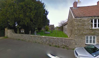
| Location | : | Leigh-on-Mendip, Mendip District, England |
| Coordinate | : | 51.2239000, -2.4416000 |
frequently asked questions (FAQ):
-
Where is Saint Giles Churchyard?
Saint Giles Churchyard is located at Leigh-on-Mendip, Mendip District ,Somerset ,England.
-
Saint Giles Churchyard cemetery's updated grave count on graveviews.com?
0 memorials
-
Where are the coordinates of the Saint Giles Churchyard?
Latitude: 51.2239000
Longitude: -2.4416000
Nearby Cemetories:
1. Holy Trinity Churchyard
Coleford, Mendip District, England
Coordinate: 51.2394100, -2.4503100
2. St Edmund's Church Vobster
Mells, Mendip District, England
Coordinate: 51.2418000, -2.4244930
3. St Michael & All Angels
Stoke St Michael, Mendip District, England
Coordinate: 51.2208300, -2.4819900
4. St. Margaret's Churchyard
Frome, Mendip District, England
Coordinate: 51.2576670, -2.4242260
5. St Andrew Churchyard
Mells, Mendip District, England
Coordinate: 51.2420710, -2.3912060
6. St George's Churchyard
Whatley, Mendip District, England
Coordinate: 51.2270030, -2.3822140
7. St. Andrew's Churchyard
Holcombe, Mendip District, England
Coordinate: 51.2547850, -2.4760280
8. Saint Bartholomew Chapel Churchyard
Cranmore, Mendip District, England
Coordinate: 51.1882990, -2.4759150
9. St Bartholomew Churchyard
Cranmore, Mendip District, England
Coordinate: 51.1882670, -2.4760330
10. St. Mary's Churchyard
Mendip District, England
Coordinate: 51.1942400, -2.3928700
11. All Saints Churchyard
Nunney, Mendip District, England
Coordinate: 51.2098694, -2.3772340
12. Saint Vigor Churchyard
Stratton-on-the-Fosse, Mendip District, England
Coordinate: 51.2552000, -2.4896000
13. St. Benedict's Churchyard
Stratton-on-the-Fosse, Mendip District, England
Coordinate: 51.2560684, -2.4913545
14. Downside Abbey
Stratton-on-the-Fosse, Mendip District, England
Coordinate: 51.2544000, -2.4943000
15. St Peter and St Paul Churchyard
Kilmersdon, Mendip District, England
Coordinate: 51.2701480, -2.4372860
16. Byfields Cemetery
Nunney, Mendip District, England
Coordinate: 51.2077210, -2.3722630
17. St James Churchyard
Ashwick, Mendip District, England
Coordinate: 51.2320800, -2.5229500
18. Saint Mary Magdalene Churchyard
Great Elm, Mendip District, England
Coordinate: 51.2426040, -2.3647230
19. The Blessed Virgin Mary Churchyard
Wanstrow, Mendip District, England
Coordinate: 51.1735190, -2.4164890
20. Christ Church Churchyard
Mendip District, England
Coordinate: 51.2514920, -2.5151540
21. Christ Church, Downside
Chilcompton, Mendip District, England
Coordinate: 51.2515150, -2.5153030
22. Downside Cemetery
Chilcompton, Mendip District, England
Coordinate: 51.2517300, -2.5152400
23. St. Aldhelm Churchyard
Doulting, Mendip District, England
Coordinate: 51.1862880, -2.5077290
24. St. Leonard's Churchyard
Mendip District, England
Coordinate: 51.2033660, -2.3512620