
| Memorials | : | 749 |
| Location | : | Dunlapsville, Union County, USA |
| Coordinate | : | 39.5894852, -84.9926453 |
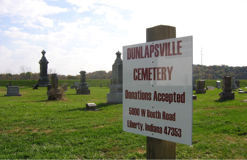
| Description | : | The cemetery is located in Liberty Township (S half of Section 28 Township 11n Range 2W) at the south end of S Treat Line Road at its intersection with W Templeton Drive. Indiana Cemetery Locations, Volume 1, published by the Indiana Genealogical Society (02 April 2005), gives the primary cemetery name as Dunlapsville Cemetery. The cemetery is listed in the Cemetery and Burial Grounds Registry of the Indiana Department of Natural Resources (DNR) and in the State Historical Architectural and Archaeological Research Database (SHAARD) with Cemetery Record Number CR-81-39 (Dunlapsville Presbyterian). The Indiana Historic Sites and Structures Inventory... Read More |
frequently asked questions (FAQ):
-
Where is Dunlapsville Cemetery?
Dunlapsville Cemetery is located at S Treaty Line Road Dunlapsville, Union County ,Indiana , 47353USA.
-
Dunlapsville Cemetery cemetery's updated grave count on graveviews.com?
749 memorials
-
Where are the coordinates of the Dunlapsville Cemetery?
Latitude: 39.5894852
Longitude: -84.9926453
Nearby Cemetories:
1. New Hope Cemetery
Harmony Township, Union County, USA
Coordinate: 39.5682983, -84.9468994
2. Mount Pleasant Cemetery
Dunlapsville, Union County, USA
Coordinate: 39.6280400, -85.0159240
3. Hanson-Crandel Cemetery
Connersville, Fayette County, USA
Coordinate: 39.5984100, -85.0501400
4. Old DuBois Cemetery
Harmony Township, Union County, USA
Coordinate: 39.5522750, -84.9577740
5. Silver Creek Friends Cemetery
Center Township, Union County, USA
Coordinate: 39.6110440, -84.9384080
6. Poplar Ridge Cemetery
Everton, Fayette County, USA
Coordinate: 39.5619000, -85.0447000
7. Calvary Cemetery
Liberty, Union County, USA
Coordinate: 39.6217003, -84.9364014
8. Silver Creek Cemetery
Liberty, Union County, USA
Coordinate: 39.6363690, -84.9536790
9. Sims Cemetery (Defunct)
Liberty, Union County, USA
Coordinate: 39.5309750, -84.9956820
10. Mount Garrison Cemetery
Everton, Fayette County, USA
Coordinate: 39.5842018, -85.0730972
11. Burk Cemetery
Fayette County, USA
Coordinate: 39.6206500, -85.0645700
12. Bath Springs Cemetery
Harmony Township, Union County, USA
Coordinate: 39.5307990, -84.9575700
13. West Point Cemetery
Liberty, Union County, USA
Coordinate: 39.6393890, -84.9372450
14. Ward Cemetery
Liberty, Union County, USA
Coordinate: 39.6062280, -84.9090640
15. Patterson Cemetery
Liberty, Union County, USA
Coordinate: 39.6514015, -84.9468994
16. Drook Cemetery
Liberty, Union County, USA
Coordinate: 39.6306000, -84.9167023
17. Brownsville City Cemetery
Brownsville, Union County, USA
Coordinate: 39.6612015, -85.0065002
18. Christian Union Cemetery
Brownsville, Union County, USA
Coordinate: 39.6621094, -85.0030212
19. Coe Family Cemetery
Billingsville, Union County, USA
Coordinate: 39.5404000, -84.9205000
20. Woods Cemetery
Connersville, Fayette County, USA
Coordinate: 39.5946330, -85.0900870
21. Union Cemetery
Lyonsville, Fayette County, USA
Coordinate: 39.6492990, -85.0548080
22. Sims-Brier Cemetery
Old Bath, Franklin County, USA
Coordinate: 39.5158386, -84.9646606
23. Simpson Cemetery
Fayette County, USA
Coordinate: 39.6561130, -85.0435840
24. Salem Friends Cemetery
Salem, Union County, USA
Coordinate: 39.6047058, -84.8904114