
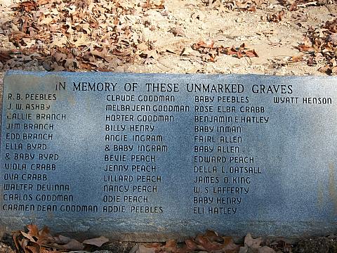
| Memorials | : | 90 |
| Location | : | Rockport, Benton County, USA |
| Coordinate | : | 35.9163200, -87.9833700 |
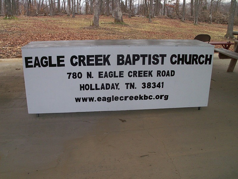
| Description | : | The Eagle Creek Cemetery (sometimes called Byrd's Hill) is located in the Eagle Creek community on Eagle Creek Rd approximately 1 mile east of TN 191 (Old Birdsong Rd). It is located on a hill behind Eagle Creek Baptist Church. The Eagle Creek Cemetery (sometimes called Byrd's Hill) is located in the Eagle Creek community on Eagle Creek Rd approximately 1 mile east of TN 191 (Old Birdsong Rd). It is located on a hill behind Eagle Creek Baptist Church. |
frequently asked questions (FAQ):
-
Where is Eagle Creek Church Cemetery?
Eagle Creek Church Cemetery is located at Rockport, Benton County ,Tennessee ,USA.
-
Eagle Creek Church Cemetery cemetery's updated grave count on graveviews.com?
90 memorials
-
Where are the coordinates of the Eagle Creek Church Cemetery?
Latitude: 35.9163200
Longitude: -87.9833700
Nearby Cemetories:
1. DePriest Cemetery
Benton County, USA
Coordinate: 35.9219017, -87.9713974
2. Matlock Cemetery
Benton County, USA
Coordinate: 35.9030991, -87.9944000
3. Dry Branch Cemetery
Holladay, Benton County, USA
Coordinate: 35.8985190, -87.9915550
4. Peebles Sims Cemetery
Benton County, USA
Coordinate: 35.9236650, -88.0101830
5. Malin Cemetery
Holladay, Benton County, USA
Coordinate: 35.8955430, -88.0161442
6. Wilbanks Cemetery
Holladay, Benton County, USA
Coordinate: 35.8831960, -87.9942490
7. Pavatt-Whitfield Cemetery
Holladay, Benton County, USA
Coordinate: 35.9260620, -87.9387750
8. Fry Cemetery
Holladay, Benton County, USA
Coordinate: 35.8966530, -88.0252880
9. Byrd Cemetery
Holladay, Benton County, USA
Coordinate: 35.9346950, -87.9382920
10. Capps Cemetery
Holladay, Benton County, USA
Coordinate: 35.8997002, -88.0444031
11. Arrington Cemetery
Humphreys County, USA
Coordinate: 35.9082985, -87.9188995
12. Baker McAuley Cemetery
Benton County, USA
Coordinate: 35.9556007, -88.0274963
13. Luper Cemetery
Holladay, Benton County, USA
Coordinate: 35.9522370, -88.0372720
14. Hamm Cemetery
Buffalo, Humphreys County, USA
Coordinate: 35.8816986, -87.9274979
15. Dreden Cemetery
Humphreys County, USA
Coordinate: 35.9397011, -87.9158020
16. Old Dreaden Family Cemetery
Bakerville, Humphreys County, USA
Coordinate: 35.9396600, -87.9156800
17. Davis Cemetery
Birdsong Heights, Benton County, USA
Coordinate: 35.9578780, -88.0381140
18. Dalton Cemetery
Mount Moriah, Benton County, USA
Coordinate: 35.9566680, -88.0498480
19. Mount Moriah Cumberland Presbyterian Cemetery
Mount Moriah, Benton County, USA
Coordinate: 35.9620058, -88.0444794
20. Ebenezer United Methodist Church Cemetery
Denver, Humphreys County, USA
Coordinate: 35.9831160, -87.9630590
21. Arthur Hatley Cemetery
Rockport, Benton County, USA
Coordinate: 35.9358430, -88.0661280
22. Hatley Cemetery
Mount Moriah, Benton County, USA
Coordinate: 35.9358430, -88.0661280
23. Hatley Cemetery
Benton County, USA
Coordinate: 35.9361000, -88.0661011
24. Estes Cemetery
Humphreys County, USA
Coordinate: 35.9893990, -87.9841995